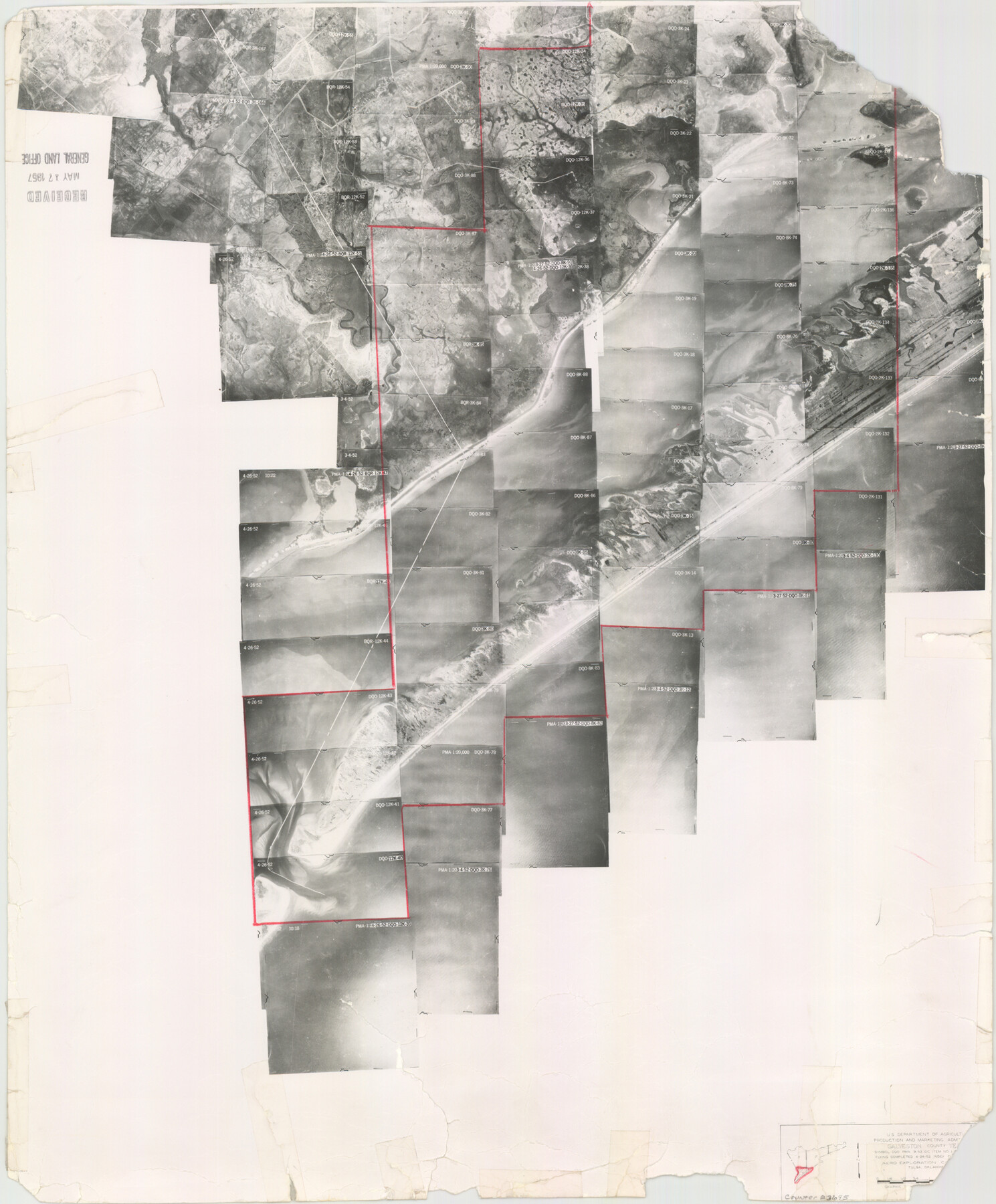
Galveston County Aerial Photograph Index Sheet 4
Galveston County Aerial Photograph Index 4
-
Map/Doc
83695
-
Collection
General Map Collection
-
Object Dates
1953/2/10 (Creation Date)
-
People and Organizations
U. S. Department of Agriculture (Publisher)
-
Counties
Galveston
-
Subjects
Aerial Photograph
-
Height x Width
23.5 x 19.4 inches
59.7 x 49.3 cm
-
Comments
Flying completed April 26, 1952 by Aero Exploration Company of Tulsa, Oklahoma.
Received in office May 17, 1957.
Part of: General Map Collection

Duval County Boundary File 3m

Print $8.00
- Digital $50.00
Duval County Boundary File 3m
Size 12.8 x 8.1 inches
Map/Doc 52763
Live Oak County Sketch File 32

Print $6.00
- Digital $50.00
Live Oak County Sketch File 32
1951
Size 11.1 x 8.6 inches
Map/Doc 30330

Chart of the Rio Bravo del Norte traced from a survey made by Henry Austin by Lieut. Bowman, 3d. Infy.

Print $20.00
- Digital $50.00
Chart of the Rio Bravo del Norte traced from a survey made by Henry Austin by Lieut. Bowman, 3d. Infy.
1866
Size 18.3 x 27.8 inches
Map/Doc 72889
Presidio County Rolled Sketch 141

Print $20.00
- Digital $50.00
Presidio County Rolled Sketch 141
Size 40.8 x 28.6 inches
Map/Doc 89064
Ector County Working Sketch 4

Print $20.00
- Digital $50.00
Ector County Working Sketch 4
1940
Size 25.8 x 30.0 inches
Map/Doc 68847
Denton County Sketch File 3

Print $4.00
- Digital $50.00
Denton County Sketch File 3
1855
Size 12.5 x 8.2 inches
Map/Doc 20688
Map of Ramon Musquiz Survey, Meanders of Lavaca & Navidad Rivers, Menefee & Redfish Lakes

Print $20.00
- Digital $50.00
Map of Ramon Musquiz Survey, Meanders of Lavaca & Navidad Rivers, Menefee & Redfish Lakes
1934
Size 24.4 x 18.0 inches
Map/Doc 65453
Old Miscellaneous File 25

Print $40.00
- Digital $50.00
Old Miscellaneous File 25
Size 17.8 x 15.2 inches
Map/Doc 75632
Stonewall County Sketch File 27

Print $8.00
- Digital $50.00
Stonewall County Sketch File 27
1955
Size 10.9 x 7.2 inches
Map/Doc 37296
Runnels County Sketch File 36

Print $20.00
Runnels County Sketch File 36
1889
Size 20.9 x 19.6 inches
Map/Doc 12267
You may also like
Flight Mission No. DQN-1K, Frame 67, Calhoun County

Print $20.00
- Digital $50.00
Flight Mission No. DQN-1K, Frame 67, Calhoun County
1953
Size 18.3 x 22.1 inches
Map/Doc 84154
Cooke County Sketch File 20

Print $22.00
- Digital $50.00
Cooke County Sketch File 20
1862
Size 9.1 x 6.9 inches
Map/Doc 19264
Post Route Map of Texas (Inset 1: Dallas-Fort Worth Area; Inset 2: Texas Panhandle)

Print $40.00
- Digital $50.00
Post Route Map of Texas (Inset 1: Dallas-Fort Worth Area; Inset 2: Texas Panhandle)
1939
Size 56.8 x 39.2 inches
Map/Doc 93699
Montgomery County Rolled Sketch 35

Print $40.00
- Digital $50.00
Montgomery County Rolled Sketch 35
Size 36.7 x 51.3 inches
Map/Doc 9543
Chart of the Harbour of San [Luis]
![72761, Chart of the Harbour of San [Luis], General Map Collection](https://historictexasmaps.com/wmedia_w700/maps/72761.tif.jpg)
Print $20.00
- Digital $50.00
Chart of the Harbour of San [Luis]
1846
Size 27.3 x 18.3 inches
Map/Doc 72761
Flight Mission No. CGI-4N, Frame 195, Cameron County

Print $20.00
- Digital $50.00
Flight Mission No. CGI-4N, Frame 195, Cameron County
1955
Size 18.5 x 22.3 inches
Map/Doc 84698
Colorado County Working Sketch 10

Print $20.00
- Digital $50.00
Colorado County Working Sketch 10
1940
Size 23.2 x 24.4 inches
Map/Doc 68110

[H. & G. N. Block 1, Sections 128-130]
![90948, [H. & G. N. Block 1, Sections 128-130], Twichell Survey Records](https://historictexasmaps.com/wmedia_w700/maps/90948-1.tif.jpg)
Print $20.00
- Digital $50.00
[H. & G. N. Block 1, Sections 128-130]
Size 36.6 x 11.9 inches
Map/Doc 90948
Hunt County Boundary File 2

Print $6.00
- Digital $50.00
Hunt County Boundary File 2
Size 13.0 x 8.1 inches
Map/Doc 55189
Real County Working Sketch 89

Print $20.00
- Digital $50.00
Real County Working Sketch 89
Size 28.0 x 37.1 inches
Map/Doc 71981
Roberts County

Print $20.00
- Digital $50.00
Roberts County
1932
Size 41.9 x 38.0 inches
Map/Doc 73275