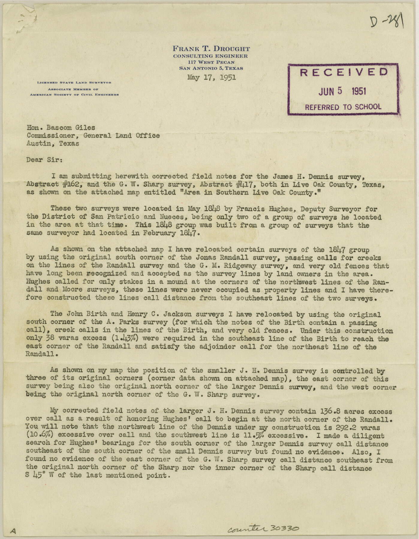
Live Oak County Sketch File 32
[Surveyor's report regarding area south of George West]
-
Map/Doc
30330
-
Collection
General Map Collection
-
Object Dates
5/17/1951 (Creation Date)
6/5/1951 (File Date)
5/17/1951 (Correspondence Date)
5/1848 (Survey Date)
2/1847 (Survey Date)
-
People and Organizations
F.T. Drought (Surveyor/Engineer)
Francis Hughes (Surveyor/Engineer)
-
Counties
Live Oak
-
Subjects
Surveying Sketch File
-
Height x Width
11.1 x 8.6 inches
28.2 x 21.8 cm
-
Medium
paper, print
-
Comments
See Live Oak County Rolled Sketch 7 (6635) for sketch.
Related maps
Live Oak County Rolled Sketch 7

Print $20.00
- Digital $50.00
Live Oak County Rolled Sketch 7
1951
Size 31.3 x 36.9 inches
Map/Doc 6635
Part of: General Map Collection
Llano County Sketch File 16

Print $12.00
- Digital $50.00
Llano County Sketch File 16
1905
Size 12.3 x 11.3 inches
Map/Doc 30392
Flight Mission No. DIX-8P, Frame 71, Aransas County

Print $20.00
- Digital $50.00
Flight Mission No. DIX-8P, Frame 71, Aransas County
1956
Size 18.8 x 22.4 inches
Map/Doc 83902
Proceedings of the International Boundary Commission, United States and Mexico, American Section, Elimination of Bancos, Treaty of 1905

Proceedings of the International Boundary Commission, United States and Mexico, American Section, Elimination of Bancos, Treaty of 1905
Size 12.4 x 9.6 inches
Map/Doc 83125
Jeff Davis County Sketch File 46

Print $8.00
- Digital $50.00
Jeff Davis County Sketch File 46
1906
Size 13.5 x 8.8 inches
Map/Doc 28080
Dallam County Sketch File A

Print $20.00
- Digital $50.00
Dallam County Sketch File A
1903
Size 32.3 x 20.9 inches
Map/Doc 11281
Pecos County Rolled Sketch 112

Print $20.00
- Digital $50.00
Pecos County Rolled Sketch 112
1941
Size 39.0 x 37.0 inches
Map/Doc 9720
Orange County Rolled Sketch 26

Print $20.00
- Digital $50.00
Orange County Rolled Sketch 26
1952
Size 35.2 x 43.0 inches
Map/Doc 9649
No. 1. Outline Map of the Rio Grande from its mouth up to Ringold Barracks

Print $20.00
- Digital $50.00
No. 1. Outline Map of the Rio Grande from its mouth up to Ringold Barracks
Size 24.8 x 18.3 inches
Map/Doc 72857
Montgomery County Rolled Sketch 35

Print $40.00
- Digital $50.00
Montgomery County Rolled Sketch 35
Size 36.7 x 51.3 inches
Map/Doc 9543
Crockett County Working Sketch 62

Print $40.00
- Digital $50.00
Crockett County Working Sketch 62
1956
Size 121.8 x 37.1 inches
Map/Doc 68395
Rusk County Working Sketch 26

Print $20.00
- Digital $50.00
Rusk County Working Sketch 26
1938
Size 42.8 x 36.8 inches
Map/Doc 63662
Val Verde County Working Sketch 38

Print $20.00
- Digital $50.00
Val Verde County Working Sketch 38
1943
Size 14.8 x 18.9 inches
Map/Doc 72173
You may also like
The California Case

Print $20.00
- Digital $50.00
The California Case
Size 17.6 x 12.5 inches
Map/Doc 91696
Presidio County Rolled Sketch 86

Print $20.00
- Digital $50.00
Presidio County Rolled Sketch 86
1945
Size 34.1 x 27.8 inches
Map/Doc 7372
Val Verde County Working Sketch 26

Print $20.00
- Digital $50.00
Val Verde County Working Sketch 26
1936
Size 22.9 x 31.5 inches
Map/Doc 72161
Green & Lumsden's Ranch

Print $20.00
- Digital $50.00
Green & Lumsden's Ranch
Size 28.4 x 24.7 inches
Map/Doc 92431
Presidio County Sketch File 110

Print $12.00
- Digital $50.00
Presidio County Sketch File 110
1886
Size 12.3 x 8.5 inches
Map/Doc 34818
Sutton County Rolled Sketch 66

Print $20.00
- Digital $50.00
Sutton County Rolled Sketch 66
Size 25.3 x 25.1 inches
Map/Doc 7901
Terry County Rolled Sketch 9

Print $20.00
- Digital $50.00
Terry County Rolled Sketch 9
Size 23.8 x 23.9 inches
Map/Doc 7983
Burleson County Working Sketch 6

Print $20.00
- Digital $50.00
Burleson County Working Sketch 6
1980
Size 22.3 x 16.0 inches
Map/Doc 67725
Correct Map of Lamb County, Texas

Print $40.00
- Digital $50.00
Correct Map of Lamb County, Texas
1914
Size 47.1 x 57.1 inches
Map/Doc 89954
General Highway Map, Tom Green County, Texas

Print $20.00
General Highway Map, Tom Green County, Texas
1940
Size 25.0 x 18.5 inches
Map/Doc 79260
Bandera County Sketch File 34

Print $6.00
- Digital $50.00
Bandera County Sketch File 34
1987
Size 14.1 x 8.7 inches
Map/Doc 14030
General Highway Map, Andrews County, Texas

Print $20.00
General Highway Map, Andrews County, Texas
1961
Size 25.1 x 18.3 inches
Map/Doc 79347