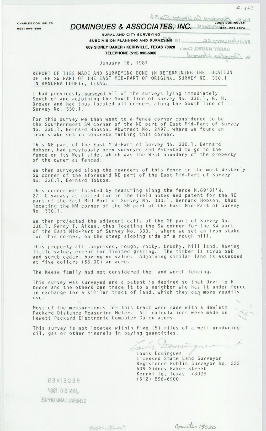
Bandera County Sketch File 34
[Report and plat of survey of 62.2 acres out of southwest part of east mid-part of original survey no. 330.1]
-
Map/Doc
14030
-
Collection
General Map Collection
-
Object Dates
1987/1/16 (Creation Date)
1986/11/5 (Survey Date)
1987/1/22 (File Date)
-
People and Organizations
Louis Domingues (Surveyor/Engineer)
-
Counties
Bandera
-
Subjects
Surveying Sketch File
-
Height x Width
14.1 x 8.7 inches
35.8 x 22.1 cm
-
Medium
multi-page, multi-format
Part of: General Map Collection
[Galveston, Harrisburg & San Antonio through El Paso County]
![64010, [Galveston, Harrisburg & San Antonio through El Paso County], General Map Collection](https://historictexasmaps.com/wmedia_w700/maps/64010.tif.jpg)
Print $20.00
- Digital $50.00
[Galveston, Harrisburg & San Antonio through El Paso County]
1906
Size 13.4 x 33.9 inches
Map/Doc 64010
Moore County Rolled Sketch 14A

Print $20.00
- Digital $50.00
Moore County Rolled Sketch 14A
1981
Size 21.8 x 27.5 inches
Map/Doc 6831
[St. Louis & Southwestern]
![64278, [St. Louis & Southwestern], General Map Collection](https://historictexasmaps.com/wmedia_w700/maps/64278.tif.jpg)
Print $20.00
- Digital $50.00
[St. Louis & Southwestern]
Size 20.8 x 28.9 inches
Map/Doc 64278
Brooks County Rolled Sketch 23

Print $40.00
- Digital $50.00
Brooks County Rolled Sketch 23
Size 42.4 x 74.4 inches
Map/Doc 8538
Brewster County Working Sketch 92

Print $40.00
- Digital $50.00
Brewster County Working Sketch 92
1975
Size 61.9 x 39.4 inches
Map/Doc 67692
Dimmit County Sketch File 7

Print $25.00
- Digital $50.00
Dimmit County Sketch File 7
Size 9.1 x 7.8 inches
Map/Doc 21067
Brewster County Rolled Sketch 114

Print $20.00
- Digital $50.00
Brewster County Rolled Sketch 114
1964
Size 12.0 x 17.5 inches
Map/Doc 5291
Flight Mission No. DCL-7C, Frame 24, Kenedy County

Print $20.00
- Digital $50.00
Flight Mission No. DCL-7C, Frame 24, Kenedy County
1943
Size 15.5 x 15.4 inches
Map/Doc 86016

Tyler County Working Sketch Graphic Index

Print $20.00
- Digital $50.00
Tyler County Working Sketch Graphic Index
1944
Size 47.4 x 39.6 inches
Map/Doc 76719
Fractional Township No. 8 South Range No. 5 East of the Indian Meridian, Indian Territory

Print $20.00
- Digital $50.00
Fractional Township No. 8 South Range No. 5 East of the Indian Meridian, Indian Territory
1898
Size 19.2 x 24.4 inches
Map/Doc 75209
Intracoastal Waterway in Texas - Corpus Christi to Point Isabel including Arroyo Colorado to Mo. Pac. R.R. Bridge Near Harlingen

Print $20.00
- Digital $50.00
Intracoastal Waterway in Texas - Corpus Christi to Point Isabel including Arroyo Colorado to Mo. Pac. R.R. Bridge Near Harlingen
1933
Size 28.1 x 41.4 inches
Map/Doc 61871
You may also like
Harris County Working Sketch 90

Print $20.00
- Digital $50.00
Harris County Working Sketch 90
1973
Size 46.4 x 38.6 inches
Map/Doc 65982
International boundary between U.S. & Mexico in Gulf of Mexico from 12 mile point easterly to 200 mile limit

Print $3.00
- Digital $50.00
International boundary between U.S. & Mexico in Gulf of Mexico from 12 mile point easterly to 200 mile limit
1976
Size 9.6 x 14.8 inches
Map/Doc 1748
Chart of the Antarctic Continent shewing the icy barrier attached to it discovered by the U.S. Ex. Ex.

Print $20.00
- Digital $50.00
Chart of the Antarctic Continent shewing the icy barrier attached to it discovered by the U.S. Ex. Ex.
1840
Size 26.5 x 37.2 inches
Map/Doc 94059
Reeves County Working Sketch 18

Print $20.00
- Digital $50.00
Reeves County Working Sketch 18
1961
Size 24.7 x 40.2 inches
Map/Doc 63461
Bee County Working Sketch 13

Print $20.00
- Digital $50.00
Bee County Working Sketch 13
1944
Size 26.0 x 13.0 inches
Map/Doc 67263
[Sketch for Mineral Application 26501 - Sabine River, T. A. Oldhausen]
![2833, [Sketch for Mineral Application 26501 - Sabine River, T. A. Oldhausen], General Map Collection](https://historictexasmaps.com/wmedia_w700/maps/2833.tif.jpg)
Print $20.00
- Digital $50.00
[Sketch for Mineral Application 26501 - Sabine River, T. A. Oldhausen]
1931
Size 24.4 x 36.3 inches
Map/Doc 2833
Chambers County Working Sketch 8

Print $20.00
- Digital $50.00
Chambers County Working Sketch 8
1940
Size 20.9 x 44.4 inches
Map/Doc 67991
Jefferson County NRC Article 33.136 Sketch 3

Print $22.00
- Digital $50.00
Jefferson County NRC Article 33.136 Sketch 3
2003
Size 22.7 x 33.9 inches
Map/Doc 78610
Edwards County

Print $40.00
- Digital $50.00
Edwards County
1900
Size 56.7 x 36.3 inches
Map/Doc 87470
Milam County Working Sketch 16

Print $20.00
- Digital $50.00
Milam County Working Sketch 16
Size 30.4 x 36.2 inches
Map/Doc 71028
Flight Mission No. DCL-7C, Frame 70, Kenedy County

Print $20.00
- Digital $50.00
Flight Mission No. DCL-7C, Frame 70, Kenedy County
1943
Size 15.4 x 15.3 inches
Map/Doc 86056
Sutton County

Print $40.00
- Digital $50.00
Sutton County
1941
Size 43.8 x 56.5 inches
Map/Doc 95647