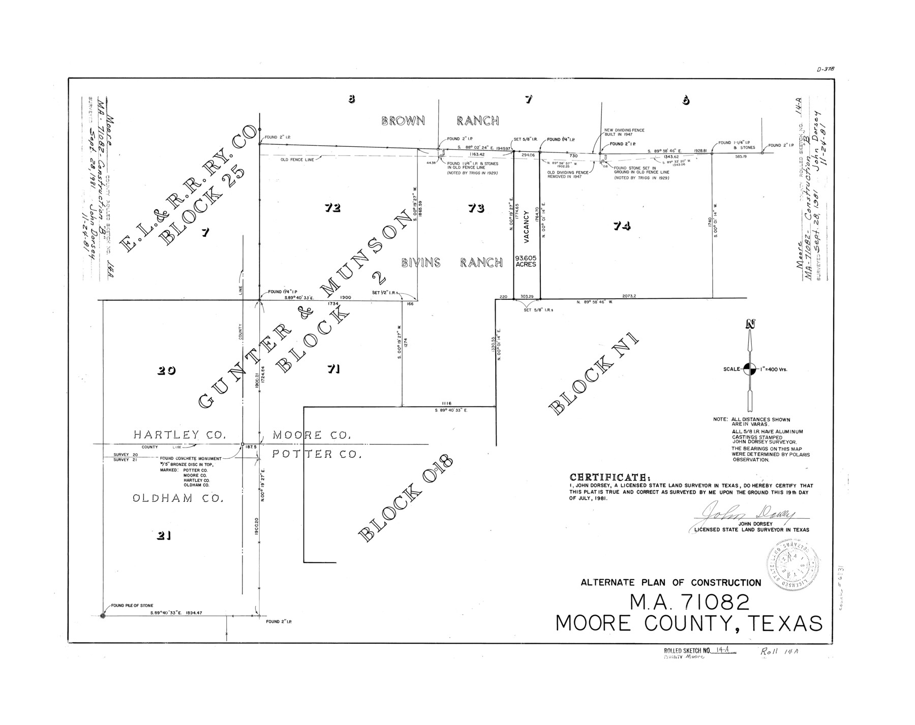
Moore County Rolled Sketch 14A
Alternate plan of construction - MA-71082, Moore County, Texas
-
Map/Doc
6831
-
Collection
General Map Collection
-
Object Dates
1981/7/19 (Creation Date)
1981/11/24 (File Date)
-
People and Organizations
John Dorsey (Surveyor/Engineer)
-
Counties
Moore Potter Hartley Oldham
-
Subjects
Surveying Rolled Sketch
-
Height x Width
21.8 x 27.5 inches
55.4 x 69.9 cm
-
Medium
mylar, print
-
Scale
1" = 400 varas
Part of: General Map Collection
Brewster County Working Sketch 47

Print $20.00
- Digital $50.00
Brewster County Working Sketch 47
1949
Size 42.9 x 35.4 inches
Map/Doc 67581
Young County Rolled Sketch 9

Print $20.00
- Digital $50.00
Young County Rolled Sketch 9
1921
Size 24.0 x 22.6 inches
Map/Doc 8297
Kaufman County State Real Property Sketch 2

Print $20.00
- Digital $50.00
Kaufman County State Real Property Sketch 2
2007
Size 24.2 x 35.4 inches
Map/Doc 88672
Flight Mission No. DCL-6C, Frame 93, Kenedy County

Print $20.00
- Digital $50.00
Flight Mission No. DCL-6C, Frame 93, Kenedy County
1943
Size 18.6 x 22.3 inches
Map/Doc 85923
Primera parte del Mapa, que comprende la Frontera, de los Dominios del Rey, en la America Septentrional

Print $40.00
- Digital $50.00
Primera parte del Mapa, que comprende la Frontera, de los Dominios del Rey, en la America Septentrional
1769
Size 25.8 x 63.2 inches
Map/Doc 3062
Galveston County NRC Article 33.136 Location Key Sheet

Print $20.00
- Digital $50.00
Galveston County NRC Article 33.136 Location Key Sheet
1994
Size 27.0 x 21.8 inches
Map/Doc 77017
Colorado County Working Sketch 2

Print $20.00
- Digital $50.00
Colorado County Working Sketch 2
1904
Size 28.8 x 30.1 inches
Map/Doc 68102
Galveston County Sketch File 67

Print $4.00
- Digital $50.00
Galveston County Sketch File 67
1988
Size 11.3 x 8.7 inches
Map/Doc 23782
Culberson County Working Sketch 56

Print $20.00
- Digital $50.00
Culberson County Working Sketch 56
1974
Size 38.7 x 32.1 inches
Map/Doc 68510
Coleman County Sketch File 27a

Print $20.00
- Digital $50.00
Coleman County Sketch File 27a
Size 22.6 x 24.3 inches
Map/Doc 11121
Red River County Red River District

Print $20.00
- Digital $50.00
Red River County Red River District
1879
Size 24.9 x 21.8 inches
Map/Doc 3976
Calhoun County Working Sketch 2a

Print $20.00
- Digital $50.00
Calhoun County Working Sketch 2a
1913
Size 17.4 x 20.1 inches
Map/Doc 67817
You may also like
Texas Gulf Coast from Sabine River to the Rio Grande

Print $20.00
- Digital $50.00
Texas Gulf Coast from Sabine River to the Rio Grande
1953
Size 45.9 x 43.6 inches
Map/Doc 2945
Frio County Sketch File 21

Print $20.00
- Digital $50.00
Frio County Sketch File 21
1938
Size 23.4 x 24.3 inches
Map/Doc 11520
Hill County Sketch File 22

Print $8.00
- Digital $50.00
Hill County Sketch File 22
1860
Size 7.7 x 8.2 inches
Map/Doc 26505
Swisher County Rolled Sketch 7

Print $40.00
- Digital $50.00
Swisher County Rolled Sketch 7
1955
Size 65.0 x 43.5 inches
Map/Doc 9983
English Field Notes of the Spanish Archives - Book A-B

English Field Notes of the Spanish Archives - Book A-B
1835
Map/Doc 96540
Parker County Working Sketch 13

Print $20.00
- Digital $50.00
Parker County Working Sketch 13
1978
Map/Doc 71463
[Index map of T. & P. Ry. Company’s 80-mile Trans-Pecos Reserve’s perpetuated corners - North Part]
![89622, [Index map of T. & P. Ry. Company’s 80-mile Trans-Pecos Reserve’s perpetuated corners - North Part], General Map Collection](https://historictexasmaps.com/wmedia_w700/maps/89622-1.tif.jpg)
Print $40.00
- Digital $50.00
[Index map of T. & P. Ry. Company’s 80-mile Trans-Pecos Reserve’s perpetuated corners - North Part]
Size 25.4 x 92.1 inches
Map/Doc 89622
DeWitt County Working Sketch 12

Print $20.00
- Digital $50.00
DeWitt County Working Sketch 12
1981
Size 17.0 x 12.5 inches
Map/Doc 68602
Flight Mission No. CRE-2R, Frame 170, Jackson County

Print $20.00
- Digital $50.00
Flight Mission No. CRE-2R, Frame 170, Jackson County
1956
Size 18.6 x 22.1 inches
Map/Doc 85380
Navarro County

Print $40.00
- Digital $50.00
Navarro County
1924
Size 41.1 x 48.2 inches
Map/Doc 77382
Tarrant County Working Sketch 12

Print $20.00
- Digital $50.00
Tarrant County Working Sketch 12
1986
Size 30.8 x 23.4 inches
Map/Doc 62429
[Capitol Leagues 294, 295, 301, 302, 303, and 304]
![91422, [Capitol Leagues 294, 295, 301, 302, 303, and 304], Twichell Survey Records](https://historictexasmaps.com/wmedia_w700/maps/91422-1.tif.jpg)
Print $20.00
- Digital $50.00
[Capitol Leagues 294, 295, 301, 302, 303, and 304]
1883
Size 16.1 x 12.5 inches
Map/Doc 91422