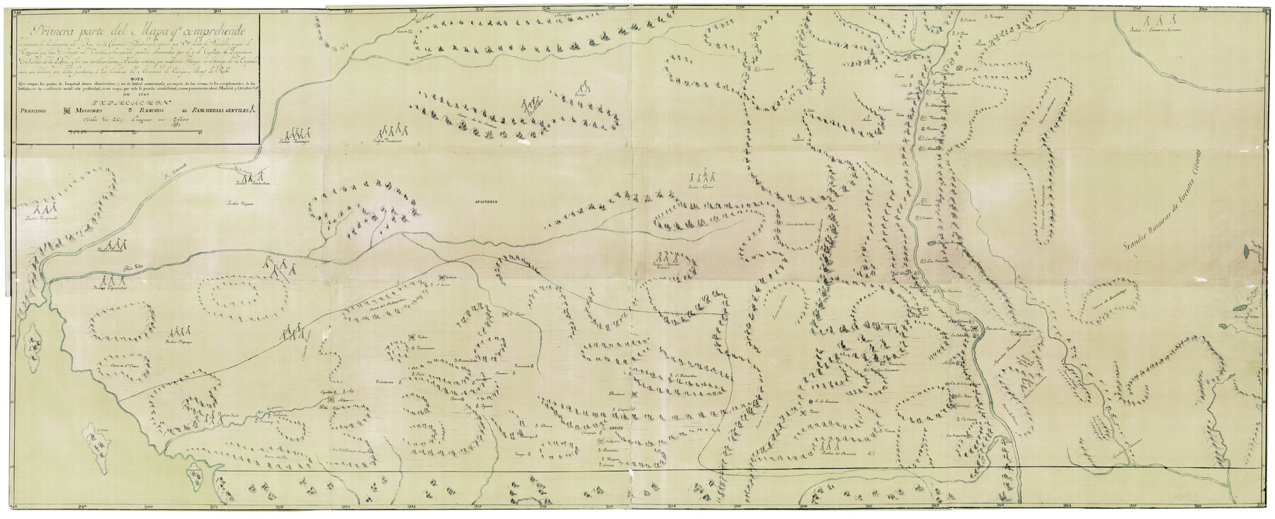
Primera parte del Mapa, que comprende la Frontera, de los Dominios del Rey, en la America Septentrional
[Translation: First part of a Map of the frontier of the King's Domain in North America]
A-7-28
-
Map/Doc
3062
-
Collection
General Map Collection
-
Object Dates
1769 (Creation Date)
-
People and Organizations
Luis de Surville (Draftsman)
Nicolas LaFora (Compiler)
Joseph de Urrutia (Compiler)
Joseph de Urrutia (Draftsman)
-
Subjects
Spanish Texas
-
Height x Width
25.8 x 63.2 inches
65.5 x 160.5 cm
-
Comments
Copied by Luis de Surville according to original made by Joseph de Urrutia on various points observed by him and the Captain of Engineering, Nicolas LaFora and the most true diaries.
For second half of map see 4667.
Related maps
Segunda parte del Mapa, que comprende la Frontera, de los Dominios del Rey, en la America Septentrional

Print $40.00
- Digital $50.00
Segunda parte del Mapa, que comprende la Frontera, de los Dominios del Rey, en la America Septentrional
1769
Size 26.7 x 63.8 inches
Map/Doc 4667
Mapa de toda la Frontera de los dominios del Rey en la America septentrional

Print $40.00
Mapa de toda la Frontera de los dominios del Rey en la America septentrional
1771
Size 26.4 x 50.0 inches
Map/Doc 95311
Mapa que comprende la Frontera de los Dominios del Rey, en la America Septentrional, segun el original que hizo D. Joseph de Urrutia, sobre varios puntos observados por él, y el Capitan de Yngenieros D. Nicolas Lafora

Print $40.00
Mapa que comprende la Frontera de los Dominios del Rey, en la America Septentrional, segun el original que hizo D. Joseph de Urrutia, sobre varios puntos observados por él, y el Capitan de Yngenieros D. Nicolas Lafora
1769
Size 50.9 x 128.2 inches
Map/Doc 95711
Plano del Presidio de Nra. Senora del Pilar de los Adaes, Capital de la Provincia de los Tejas situado en 32 grados y 15 minutos de Latitud Boreal, y en 285° y 52' de Longitud respecto del Meridiano de Tenerife

Plano del Presidio de Nra. Senora del Pilar de los Adaes, Capital de la Provincia de los Tejas situado en 32 grados y 15 minutos de Latitud Boreal, y en 285° y 52' de Longitud respecto del Meridiano de Tenerife
Size 16.9 x 21.4 inches
Map/Doc 96563
Plano de la Villa y Presidio de S. Antonio de Vejar situado en la Provincia de Tejas en 29 grad. y 52 minutos de latitud bor. y 275° y 57' de long. contados desde de Meridiano d. Tenerife

Plano de la Villa y Presidio de S. Antonio de Vejar situado en la Provincia de Tejas en 29 grad. y 52 minutos de latitud bor. y 275° y 57' de long. contados desde de Meridiano d. Tenerife
1768
Size 16.8 x 21.2 inches
Map/Doc 96564
Plano del Presidio de Bahia dela Espiritu Santo dependite dela Governacion de los Tejas situado en 29 grad. Y 39 min. de latitud boreal y 277° y 54' dela long. contados desde el Merid. De Tenerife

Plano del Presidio de Bahia dela Espiritu Santo dependite dela Governacion de los Tejas situado en 29 grad. Y 39 min. de latitud boreal y 277° y 54' dela long. contados desde el Merid. De Tenerife
1768
Size 16.7 x 21.0 inches
Map/Doc 96565
Part of: General Map Collection
Val Verde County Rolled Sketch 72

Print $20.00
- Digital $50.00
Val Verde County Rolled Sketch 72
Size 15.2 x 28.5 inches
Map/Doc 8134
Flight Mission No. DAG-23K, Frame 167, Matagorda County

Print $20.00
- Digital $50.00
Flight Mission No. DAG-23K, Frame 167, Matagorda County
1953
Size 15.9 x 19.1 inches
Map/Doc 86505
Flight Mission No. DQN-2K, Frame 124, Calhoun County

Print $20.00
- Digital $50.00
Flight Mission No. DQN-2K, Frame 124, Calhoun County
1953
Size 18.5 x 22.2 inches
Map/Doc 84300
Harris County State Real Property Sketch 3

Print $42.00
- Digital $50.00
Harris County State Real Property Sketch 3
2004
Size 24.9 x 36.9 inches
Map/Doc 81952
San Jacinto County Rolled Sketch 11

Print $20.00
- Digital $50.00
San Jacinto County Rolled Sketch 11
Size 22.7 x 33.6 inches
Map/Doc 7560
Victoria County Working Sketch 3

Print $20.00
- Digital $50.00
Victoria County Working Sketch 3
1939
Size 14.0 x 18.3 inches
Map/Doc 72273
Chambers County Working Sketch 1

Print $20.00
- Digital $50.00
Chambers County Working Sketch 1
1895
Size 29.4 x 24.9 inches
Map/Doc 67984
Smith County Sketch File 9

Print $6.00
- Digital $50.00
Smith County Sketch File 9
1848
Size 16.2 x 10.4 inches
Map/Doc 36763
Flight Mission No. BRA-7M, Frame 13, Jefferson County

Print $20.00
- Digital $50.00
Flight Mission No. BRA-7M, Frame 13, Jefferson County
1953
Size 18.6 x 22.4 inches
Map/Doc 85464
El Paso County Rolled Sketch 47

Print $40.00
- Digital $50.00
El Paso County Rolled Sketch 47
1885
Size 41.3 x 90.4 inches
Map/Doc 8874
Crockett County Sketch File 85

Print $6.00
- Digital $50.00
Crockett County Sketch File 85
1952
Size 33.7 x 31.2 inches
Map/Doc 10345
Throckmorton County Rolled Sketch 5

Print $20.00
- Digital $50.00
Throckmorton County Rolled Sketch 5
2001
Size 25.0 x 35.9 inches
Map/Doc 76405
You may also like
Chart of the World shewing the tracks of the U.S. Exploring Expedition in 1833, 39, 40, 41 & 42

Print $20.00
- Digital $50.00
Chart of the World shewing the tracks of the U.S. Exploring Expedition in 1833, 39, 40, 41 & 42
1842
Size 26.3 x 37.4 inches
Map/Doc 94057
Hays County Sketch File 22

Print $4.00
- Digital $50.00
Hays County Sketch File 22
Size 8.4 x 7.3 inches
Map/Doc 26249
Ellwood Farms, Situated in Lamb County, Texas

Print $20.00
- Digital $50.00
Ellwood Farms, Situated in Lamb County, Texas
Size 12.7 x 23.1 inches
Map/Doc 90994
McMullen County Working Sketch 30

Print $40.00
- Digital $50.00
McMullen County Working Sketch 30
1957
Size 41.4 x 50.8 inches
Map/Doc 70731
Engineer's Office, Department of the Gulf Map No. 59, Texas prepared by order of Maj. Gen. N. P. Banks under direction of Capt. P. C. Hains, U. S. Engr. & Chief Engr., Dept. of the Gulf

Print $20.00
- Digital $50.00
Engineer's Office, Department of the Gulf Map No. 59, Texas prepared by order of Maj. Gen. N. P. Banks under direction of Capt. P. C. Hains, U. S. Engr. & Chief Engr., Dept. of the Gulf
1865
Size 18.3 x 27.6 inches
Map/Doc 72717
Well Locations in Gaines County, Texas for American Liberty Oil Co.

Print $20.00
- Digital $50.00
Well Locations in Gaines County, Texas for American Liberty Oil Co.
Size 20.1 x 22.2 inches
Map/Doc 92855
Upton County Rolled Sketch 40

Print $20.00
- Digital $50.00
Upton County Rolled Sketch 40
Size 26.2 x 39.7 inches
Map/Doc 8079
Tyler County Working Sketch 22

Print $20.00
- Digital $50.00
Tyler County Working Sketch 22
1987
Size 42.0 x 35.5 inches
Map/Doc 69492
Grimes County Working Sketch 15

Print $20.00
- Digital $50.00
Grimes County Working Sketch 15
1988
Size 42.4 x 42.4 inches
Map/Doc 63306
[Surveys between the Lavaca River and Arenosa Creek]
![3184, [Surveys between the Lavaca River and Arenosa Creek], General Map Collection](https://historictexasmaps.com/wmedia_w700/maps/3184.tif.jpg)
Print $20.00
- Digital $50.00
[Surveys between the Lavaca River and Arenosa Creek]
1840
Size 25.6 x 18.9 inches
Map/Doc 3184
Hidalgo County Rolled Sketch 17

Print $40.00
- Digital $50.00
Hidalgo County Rolled Sketch 17
1963
Size 68.4 x 42.9 inches
Map/Doc 9172
Haskell County Rolled Sketch 3

Print $20.00
- Digital $50.00
Haskell County Rolled Sketch 3
1902
Size 18.1 x 21.0 inches
Map/Doc 6164