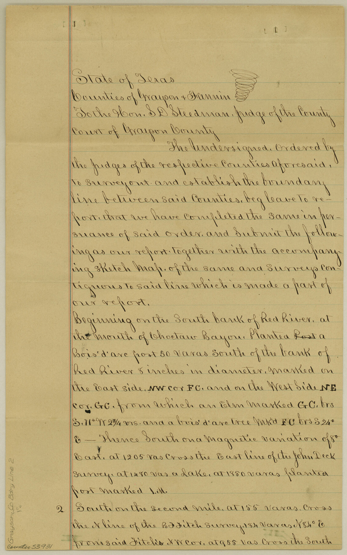
Grayson County Boundary File 2
Fieldnotes of Fannin & Grayson County line
-
Map/Doc
53931
-
Collection
General Map Collection
-
Counties
Grayson
-
Subjects
County Boundaries
-
Height x Width
12.7 x 7.9 inches
32.3 x 20.1 cm
Part of: General Map Collection

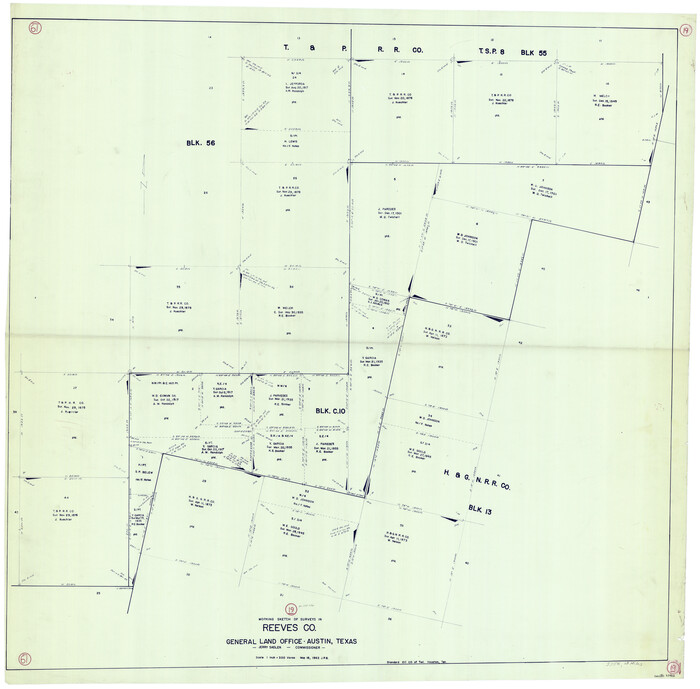
Reeves County Sketch File 7

Print $20.00
- Digital $50.00
Reeves County Sketch File 7
Size 18.3 x 19.9 inches
Map/Doc 12243
Leon County Sketch File 8

Print $4.00
- Digital $50.00
Leon County Sketch File 8
1862
Size 12.8 x 8.3 inches
Map/Doc 29724
Harris County Boundary File 39 (22)

Print $40.00
- Digital $50.00
Harris County Boundary File 39 (22)
Size 12.6 x 16.1 inches
Map/Doc 54368
Bailey County Working Sketch 3

Print $20.00
- Digital $50.00
Bailey County Working Sketch 3
1922
Size 17.3 x 28.0 inches
Map/Doc 67590
Wilson County Sketch File 12

Print $8.00
- Digital $50.00
Wilson County Sketch File 12
1841
Size 14.1 x 8.6 inches
Map/Doc 40425
Blanco County Working Sketch 19

Print $20.00
- Digital $50.00
Blanco County Working Sketch 19
1960
Size 24.4 x 29.2 inches
Map/Doc 67379
Coke County Sketch File 10

Print $6.00
- Digital $50.00
Coke County Sketch File 10
1892
Size 10.7 x 8.1 inches
Map/Doc 18587
Brewster County Rolled Sketch 9

Print $40.00
- Digital $50.00
Brewster County Rolled Sketch 9
Size 38.7 x 67.5 inches
Map/Doc 8468
Flight Mission No. DIX-6P, Frame 182, Aransas County

Print $20.00
- Digital $50.00
Flight Mission No. DIX-6P, Frame 182, Aransas County
1956
Size 19.1 x 22.8 inches
Map/Doc 83844
Lubbock County Sketch File 3

Print $4.00
- Digital $50.00
Lubbock County Sketch File 3
1901
Size 13.0 x 8.2 inches
Map/Doc 30420
Galveston Bay Entrance - Galveston and Texas City Harbors

Print $40.00
- Digital $50.00
Galveston Bay Entrance - Galveston and Texas City Harbors
Size 38.3 x 54.8 inches
Map/Doc 78271
You may also like
Flight Mission No. DAG-28K, Frame 33, Matagorda County

Print $20.00
- Digital $50.00
Flight Mission No. DAG-28K, Frame 33, Matagorda County
1953
Size 16.2 x 16.0 inches
Map/Doc 86601
Working Sketch Hale County

Print $20.00
- Digital $50.00
Working Sketch Hale County
1909
Size 17.9 x 20.9 inches
Map/Doc 90745
Andrews County Working Sketch 4

Print $20.00
- Digital $50.00
Andrews County Working Sketch 4
1954
Size 42.8 x 19.2 inches
Map/Doc 67050
Mason County Boundary File 3

Print $52.00
- Digital $50.00
Mason County Boundary File 3
Size 13.7 x 8.7 inches
Map/Doc 56838
Flight Mission No. BRA-16M, Frame 104, Jefferson County

Print $20.00
- Digital $50.00
Flight Mission No. BRA-16M, Frame 104, Jefferson County
1953
Size 18.5 x 22.3 inches
Map/Doc 85716
Freestone County Sketch File 18

Print $4.00
- Digital $50.00
Freestone County Sketch File 18
1854
Size 9.7 x 8.2 inches
Map/Doc 23076
Flight Mission No. DAG-21K, Frame 101, Matagorda County

Print $20.00
- Digital $50.00
Flight Mission No. DAG-21K, Frame 101, Matagorda County
1952
Size 18.6 x 22.4 inches
Map/Doc 86430
Harris County Sketch File G

Print $4.00
- Digital $50.00
Harris County Sketch File G
1860
Size 6.6 x 7.3 inches
Map/Doc 25319
Reeves County Working Sketch 19
Print $20.00
- Digital $50.00
Reeves County Working Sketch 19
1962
Size 42.3 x 42.7 inches
Map/Doc 63462
Palo Pinto County Working Sketch 12

Print $20.00
- Digital $50.00
Palo Pinto County Working Sketch 12
1946
Size 21.1 x 33.7 inches
Map/Doc 71395

[Blocks C-19 and C-20]
![93029, [Blocks C-19 and C-20], Twichell Survey Records](https://historictexasmaps.com/wmedia_w700/maps/93029-2.tif.jpg)
Print $40.00
- Digital $50.00
[Blocks C-19 and C-20]
Size 48.7 x 20.2 inches
Map/Doc 93029