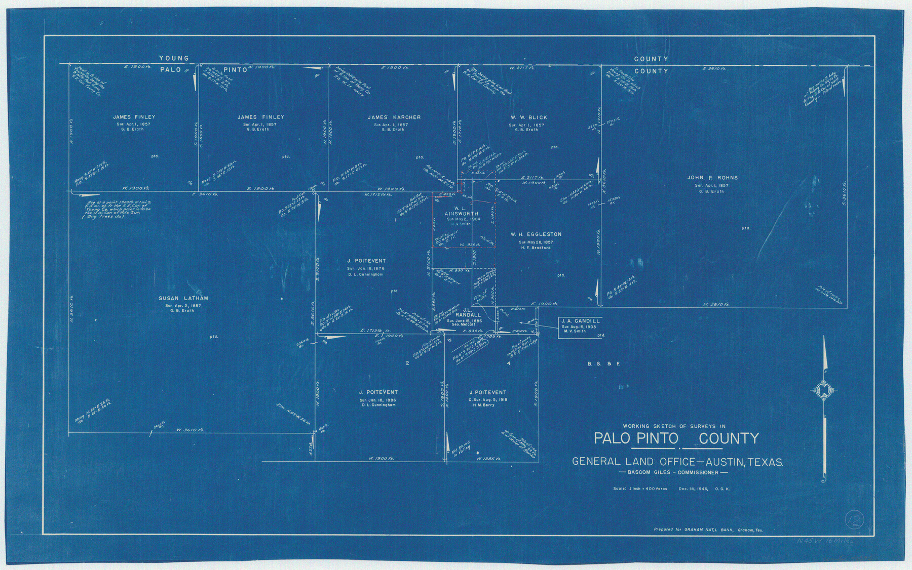
Palo Pinto County Working Sketch 12
-
Map/Doc
71395
-
Collection
General Map Collection
-
Object Dates
12/14/1946 (Creation Date)
-
People and Organizations
Otto G. Kurio (Draftsman)
-
Counties
Palo Pinto
-
Subjects
Surveying Working Sketch
-
Height x Width
21.1 x 33.7 inches
53.6 x 85.6 cm
-
Scale
1" = 400 varas
Part of: General Map Collection
Flight Mission No. DIX-10P, Frame 176, Aransas County

Print $20.00
- Digital $50.00
Flight Mission No. DIX-10P, Frame 176, Aransas County
1956
Size 18.6 x 22.3 inches
Map/Doc 83966
Donley County Sketch File 9

Print $4.00
- Digital $50.00
Donley County Sketch File 9
1884
Size 6.6 x 7.7 inches
Map/Doc 21238
Flight Mission No. BRE-2P, Frame 68, Nueces County

Print $20.00
- Digital $50.00
Flight Mission No. BRE-2P, Frame 68, Nueces County
1956
Size 18.6 x 22.4 inches
Map/Doc 86763
Reagan County Working Sketch 45

Print $20.00
- Digital $50.00
Reagan County Working Sketch 45
1987
Size 30.1 x 43.1 inches
Map/Doc 71887
Maverick County Boundary File 1

Print $48.00
- Digital $50.00
Maverick County Boundary File 1
Size 14.2 x 8.7 inches
Map/Doc 56901
Harris County Working Sketch 26

Print $20.00
- Digital $50.00
Harris County Working Sketch 26
1930
Size 23.9 x 27.2 inches
Map/Doc 65918
Terrell County Sketch File 13

Print $20.00
- Digital $50.00
Terrell County Sketch File 13
1911
Size 13.7 x 20.4 inches
Map/Doc 12420
Brewster County Working Sketch 68

Print $20.00
- Digital $50.00
Brewster County Working Sketch 68
1958
Size 23.3 x 22.6 inches
Map/Doc 67669
Map of Galveston, Turtle & East Bays & portions of the Gulf of Mexico in Chambers & Galveston Counties, Texas showing subdivision for mineral development

Print $40.00
- Digital $50.00
Map of Galveston, Turtle & East Bays & portions of the Gulf of Mexico in Chambers & Galveston Counties, Texas showing subdivision for mineral development
1949
Size 48.9 x 54.8 inches
Map/Doc 2977
Zapata County Sketch File 6

Print $22.00
- Digital $50.00
Zapata County Sketch File 6
1913
Size 22.1 x 32.7 inches
Map/Doc 12720
Webb County Working Sketch 21

Print $20.00
- Digital $50.00
Webb County Working Sketch 21
1926
Size 28.7 x 24.7 inches
Map/Doc 72386
Galveston County Rolled Sketch Z63

Print $20.00
- Digital $50.00
Galveston County Rolled Sketch Z63
1935
Size 34.6 x 22.5 inches
Map/Doc 5995
You may also like
Pecos County Working Sketch 133

Print $20.00
- Digital $50.00
Pecos County Working Sketch 133
1979
Size 44.0 x 37.2 inches
Map/Doc 71607
Bowie County Working Sketch 4

Print $20.00
- Digital $50.00
Bowie County Working Sketch 4
1915
Size 19.5 x 14.3 inches
Map/Doc 67408

General Highway Map. Detail of Cities and Towns in McLennan County, Texas [Waco and vicinity]
![79192, General Highway Map. Detail of Cities and Towns in McLennan County, Texas [Waco and vicinity], Texas State Library and Archives](https://historictexasmaps.com/wmedia_w700/maps/79192.tif.jpg)
Print $20.00
General Highway Map. Detail of Cities and Towns in McLennan County, Texas [Waco and vicinity]
1940
Size 18.2 x 24.7 inches
Map/Doc 79192
Washington County

Print $40.00
- Digital $50.00
Washington County
1920
Size 33.4 x 48.6 inches
Map/Doc 63112
Wheeler County Working Sketch 2

Print $40.00
- Digital $50.00
Wheeler County Working Sketch 2
1957
Size 35.2 x 58.5 inches
Map/Doc 72491
Montgomery County Sketch File 39

Print $4.00
- Digital $50.00
Montgomery County Sketch File 39
1941
Size 14.6 x 8.6 inches
Map/Doc 31923
Brownfield Plant Arizona Chemical Co.

Print $20.00
- Digital $50.00
Brownfield Plant Arizona Chemical Co.
Size 27.0 x 44.4 inches
Map/Doc 92417
The Coast & Bays of Western Texas

Print $20.00
- Digital $50.00
The Coast & Bays of Western Texas
1857
Size 18.2 x 23.9 inches
Map/Doc 73424
Orange County Working Sketch 3

Print $20.00
- Digital $50.00
Orange County Working Sketch 3
1917
Size 12.7 x 20.3 inches
Map/Doc 71335
General Highway Map, Briscoe County, Texas

Print $20.00
General Highway Map, Briscoe County, Texas
1940
Size 18.5 x 24.9 inches
Map/Doc 79029
[Surveys in Bexar County]
![93, [Surveys in Bexar County], General Map Collection](https://historictexasmaps.com/wmedia_w700/maps/93.tif.jpg)
Print $2.00
- Digital $50.00
[Surveys in Bexar County]
Size 11.3 x 6.9 inches
Map/Doc 93