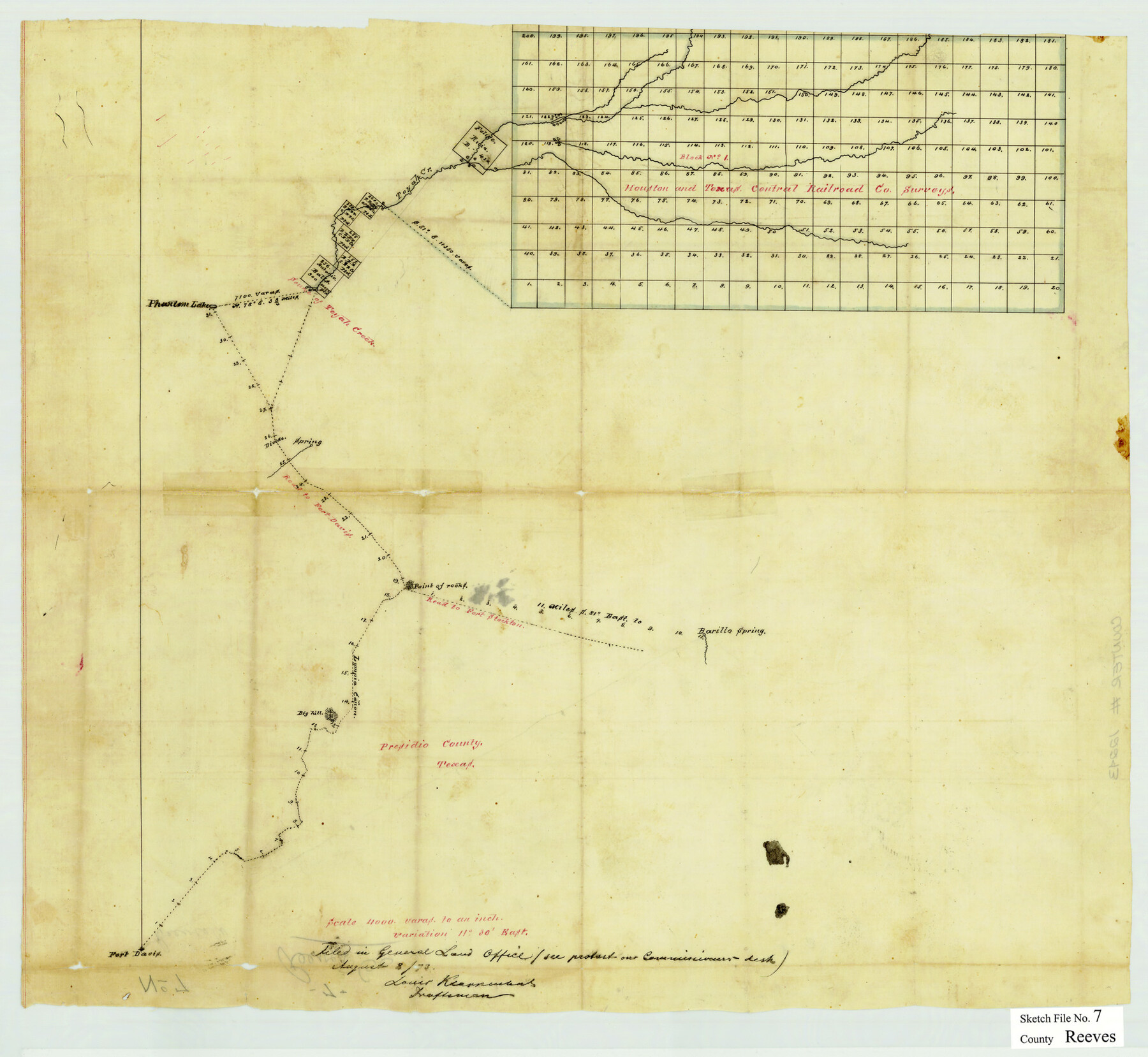
Reeves County Sketch File 7
[H&TCRRCo. Block 1, Reeves County, Texas]
-
Map/Doc
12243
-
Collection
General Map Collection
-
Object Dates
1873/8/8 (File Date)
-
People and Organizations
Louis Kearnmant (Draftsman)
-
Counties
Reeves Presidio
-
Subjects
Surveying Sketch File
-
Height x Width
18.3 x 19.9 inches
46.5 x 50.5 cm
-
Medium
paper, manuscript
-
Scale
1:4000
-
Features
Toyah Creek
Phantom Lake
Road to Fort Davis
Road to Fort Stockton
Barillo Spring
Lympia Canon
Fort Davis
Part of: General Map Collection
[Ft. W. & R. G. Ry. Right of Way Map, Chapin to Bluffdale, Hood County, Texas]
![64646, [Ft. W. & R. G. Ry. Right of Way Map, Chapin to Bluffdale, Hood County, Texas], General Map Collection](https://historictexasmaps.com/wmedia_w700/maps/64646.tif.jpg)
Print $40.00
- Digital $50.00
[Ft. W. & R. G. Ry. Right of Way Map, Chapin to Bluffdale, Hood County, Texas]
1918
Size 36.8 x 69.7 inches
Map/Doc 64646

Presidio County Working Sketch 144

Print $20.00
- Digital $50.00
Presidio County Working Sketch 144
1990
Size 20.4 x 26.6 inches
Map/Doc 71822
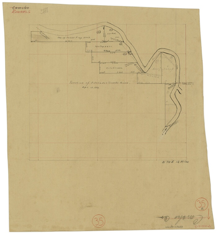
Runnels County Working Sketch 35a
Print $20.00
- Digital $50.00
Runnels County Working Sketch 35a
Size 14.9 x 14.2 inches
Map/Doc 63633
Flight Mission No. CRC-3R, Frame 47, Chambers County

Print $20.00
- Digital $50.00
Flight Mission No. CRC-3R, Frame 47, Chambers County
1956
Size 18.6 x 22.3 inches
Map/Doc 84820
Harrison County Sketch File 2

Print $4.00
- Digital $50.00
Harrison County Sketch File 2
1853
Size 8.1 x 9.9 inches
Map/Doc 26034
Hood County Rolled Sketch 6

Print $20.00
- Digital $50.00
Hood County Rolled Sketch 6
Size 20.4 x 26.5 inches
Map/Doc 6222

Polk County Working Sketch 10

Print $40.00
- Digital $50.00
Polk County Working Sketch 10
1937
Size 42.7 x 48.4 inches
Map/Doc 71625
Dawson County Sketch File 3

Print $20.00
- Digital $50.00
Dawson County Sketch File 3
Size 13.5 x 37.8 inches
Map/Doc 11290
Austin County

Print $20.00
- Digital $50.00
Austin County
1943
Size 40.1 x 42.5 inches
Map/Doc 73073
Tarrant County Sketch File 31

Print $20.00
- Digital $50.00
Tarrant County Sketch File 31
Size 27.2 x 39.3 inches
Map/Doc 10380
You may also like
Nueces County NRC Article 33.136 Sketch 19

Print $38.00
- Digital $50.00
Nueces County NRC Article 33.136 Sketch 19
2015
Size 35.0 x 22.0 inches
Map/Doc 94767
Eastland County Sketch File 6

Print $4.00
- Digital $50.00
Eastland County Sketch File 6
1871
Size 8.3 x 12.8 inches
Map/Doc 21572
Flight Mission No. DCL-5C, Frame 49, Kenedy County

Print $20.00
- Digital $50.00
Flight Mission No. DCL-5C, Frame 49, Kenedy County
1943
Size 18.5 x 22.3 inches
Map/Doc 85845
Galveston Harbor and Channel, Texas Rehabilitation of South Jetty, Comparison of Shorelines and Offshore Contours 1890 to 1960

Print $20.00
- Digital $50.00
Galveston Harbor and Channel, Texas Rehabilitation of South Jetty, Comparison of Shorelines and Offshore Contours 1890 to 1960
1961
Size 31.6 x 41.8 inches
Map/Doc 61827
[Sketch showing Block 47, sections 77-108]
![91732, [Sketch showing Block 47, sections 77-108], Twichell Survey Records](https://historictexasmaps.com/wmedia_w700/maps/91732-1.tif.jpg)
Print $20.00
- Digital $50.00
[Sketch showing Block 47, sections 77-108]
1919
Size 20.5 x 34.1 inches
Map/Doc 91732
Map of Anderson County

Print $20.00
- Digital $50.00
Map of Anderson County
1876
Size 19.4 x 21.9 inches
Map/Doc 3228
Tom Green County Sketch File 14

Print $20.00
- Digital $50.00
Tom Green County Sketch File 14
Size 34.8 x 45.7 inches
Map/Doc 10401
Map of the St. Louis, Iron Mountain and Southern Railway, and connections

Print $20.00
- Digital $50.00
Map of the St. Louis, Iron Mountain and Southern Railway, and connections
1877
Size 13.0 x 18.9 inches
Map/Doc 95783
La Salle County Working Sketch 28

Print $20.00
- Digital $50.00
La Salle County Working Sketch 28
1954
Size 36.8 x 37.8 inches
Map/Doc 70329

Hutchinson County Working Sketch 20

Print $20.00
- Digital $50.00
Hutchinson County Working Sketch 20
1960
Size 27.5 x 23.1 inches
Map/Doc 66380
Drum, Oyster and Bastrop Bays and Vicinity; Brazoria County, showing Subdivision for Mineral Development

Print $20.00
- Digital $50.00
Drum, Oyster and Bastrop Bays and Vicinity; Brazoria County, showing Subdivision for Mineral Development
1949
Size 35.4 x 45.4 inches
Map/Doc 1908