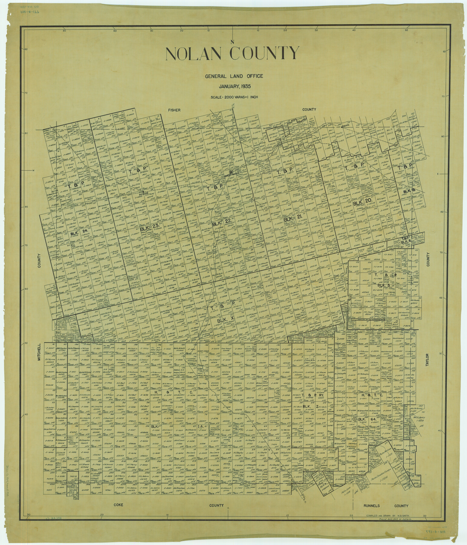
Nolan County
RM-4-177
-
Map/Doc
66954
-
Collection
General Map Collection
-
Object Dates
1935 (Creation Date)
-
People and Organizations
Texas General Land Office (Publisher)
W.B. Smith (Draftsman)
W.B. Smith (Compiler)
-
Counties
Nolan
-
Subjects
County
-
Height x Width
44.4 x 38.0 inches
112.8 x 96.5 cm
-
Comments
Traced in April 1935 by A. Clark.
Part of: General Map Collection
Flight Mission No. DAG-18K, Frame 73, Matagorda County

Print $20.00
- Digital $50.00
Flight Mission No. DAG-18K, Frame 73, Matagorda County
1952
Size 18.5 x 22.2 inches
Map/Doc 86366
Shelby County Working Sketch 18

Print $20.00
- Digital $50.00
Shelby County Working Sketch 18
1957
Size 20.7 x 27.4 inches
Map/Doc 63871
Rio Grande, Brownsville Sheet No. 1

Print $6.00
- Digital $50.00
Rio Grande, Brownsville Sheet No. 1
1924
Size 28.3 x 35.4 inches
Map/Doc 65130
Rucker's Work on Upper Red River

Print $20.00
- Digital $50.00
Rucker's Work on Upper Red River
1857
Size 39.3 x 26.2 inches
Map/Doc 3220
Dallas County Working Sketch 10

Print $20.00
- Digital $50.00
Dallas County Working Sketch 10
1971
Size 22.6 x 22.7 inches
Map/Doc 68576
Coast of Texas and its defences

Print $20.00
- Digital $50.00
Coast of Texas and its defences
1864
Size 27.3 x 18.1 inches
Map/Doc 72683
Flight Mission No. DQN-1K, Frame 155, Calhoun County

Print $20.00
- Digital $50.00
Flight Mission No. DQN-1K, Frame 155, Calhoun County
1953
Size 18.5 x 22.2 inches
Map/Doc 84214
Goliad County Sketch File 23

Print $4.00
- Digital $50.00
Goliad County Sketch File 23
1877
Size 8.1 x 12.8 inches
Map/Doc 24295
Montgomery County Sketch File 18

Print $20.00
- Digital $50.00
Montgomery County Sketch File 18
1899
Size 22.1 x 19.6 inches
Map/Doc 42122

Map of the Fort Worth & Denver City Railway, Oldham County, Texas

Print $40.00
- Digital $50.00
Map of the Fort Worth & Denver City Railway, Oldham County, Texas
1887
Size 24.8 x 105.2 inches
Map/Doc 64456
Nueces County Sketch File 62

Print $4.00
- Digital $50.00
Nueces County Sketch File 62
1936
Size 8.6 x 14.3 inches
Map/Doc 32971
You may also like
Webb County Working Sketch 5

Print $20.00
- Digital $50.00
Webb County Working Sketch 5
1909
Size 20.1 x 15.4 inches
Map/Doc 72370
Eastland County Working Sketch 24

Print $20.00
- Digital $50.00
Eastland County Working Sketch 24
1922
Size 36.1 x 27.1 inches
Map/Doc 68805
I. & G. N. - International and Great Northern R.R. - International Route - Galveston, Ft. Worth, Waco, Houston, Austin, Laredo, San Antonio

Print $20.00
- Digital $50.00
I. & G. N. - International and Great Northern R.R. - International Route - Galveston, Ft. Worth, Waco, Houston, Austin, Laredo, San Antonio
1910
Size 24.0 x 16.2 inches
Map/Doc 95779
Pecos County Working Sketch 56

Print $40.00
- Digital $50.00
Pecos County Working Sketch 56
1949
Size 29.9 x 57.4 inches
Map/Doc 71528
San Patricio County Sketch File 20

Print $14.00
San Patricio County Sketch File 20
1868
Size 9.2 x 8.5 inches
Map/Doc 36069
Lavaca County Rolled Sketch 5

Print $40.00
- Digital $50.00
Lavaca County Rolled Sketch 5
Size 37.0 x 49.1 inches
Map/Doc 10288
Mills County Working Sketch 20

Print $20.00
- Digital $50.00
Mills County Working Sketch 20
1970
Size 43.1 x 43.4 inches
Map/Doc 71050
Flight Mission No. BRA-8M, Frame 122, Jefferson County

Print $20.00
- Digital $50.00
Flight Mission No. BRA-8M, Frame 122, Jefferson County
1953
Size 18.5 x 22.4 inches
Map/Doc 85618
Brazoria County, Texas

Print $20.00
- Digital $50.00
Brazoria County, Texas
1877
Size 24.7 x 21.7 inches
Map/Doc 425
Duval County Working Sketch 55

Print $20.00
- Digital $50.00
Duval County Working Sketch 55
1936
Size 25.7 x 21.6 inches
Map/Doc 68779
Sketch of a part of Galveston Island

Print $3.00
- Digital $50.00
Sketch of a part of Galveston Island
Size 10.8 x 13.8 inches
Map/Doc 430
The Principal Transportation Lines extending west from Boston, New York, Philadelphia, and Baltimore

Print $20.00
- Digital $50.00
The Principal Transportation Lines extending west from Boston, New York, Philadelphia, and Baltimore
1881
Size 17.1 x 24.4 inches
Map/Doc 95908