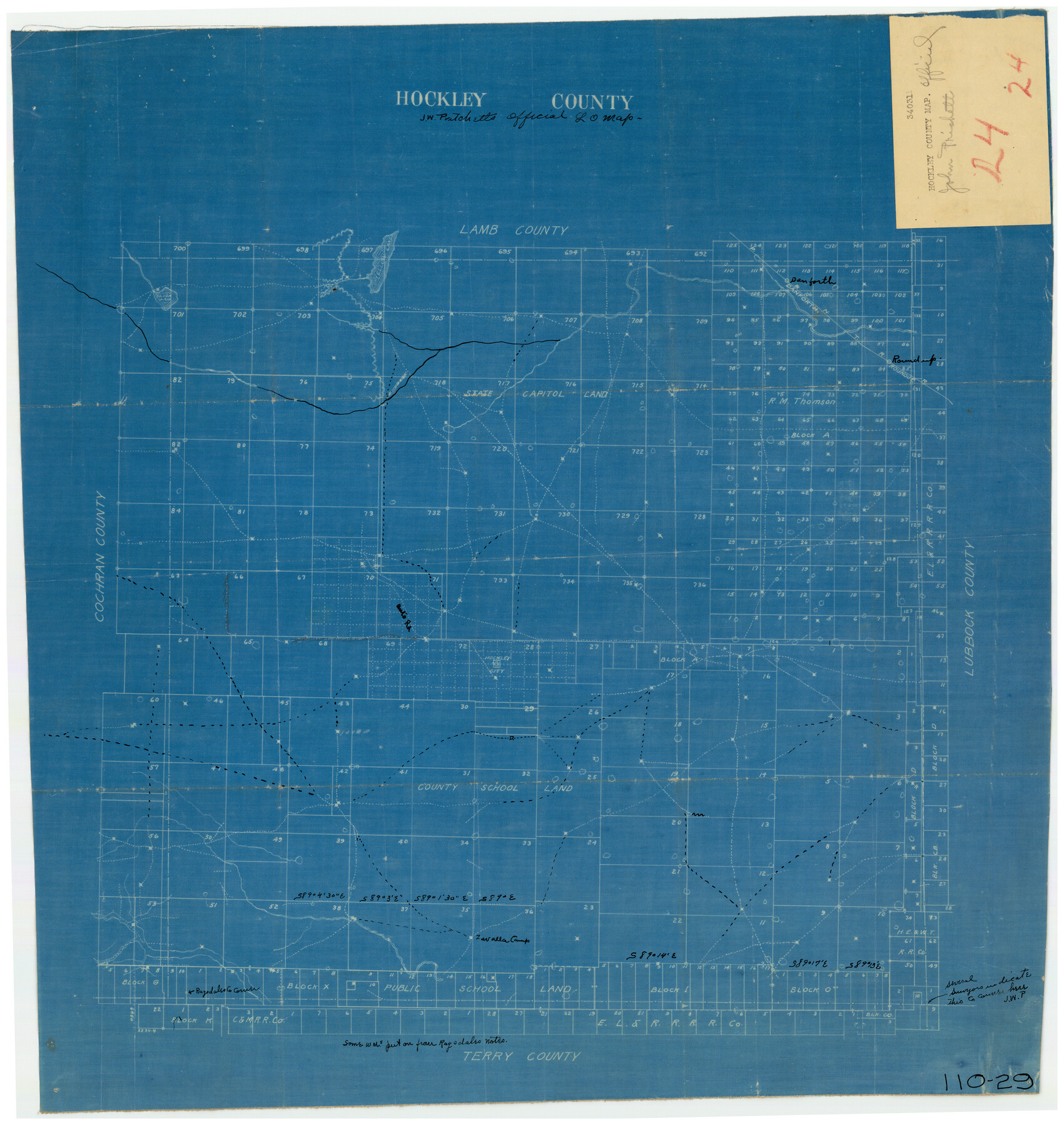
Hockley County Map
110-29
-
Map/Doc
91195
-
Collection
Twichell Survey Records
-
Counties
Hockley
-
Subjects
County
-
Height x Width
20.4 x 21.4 inches
51.8 x 54.4 cm
Part of: Twichell Survey Records
Map Showing Lands Surveyed by Sylvan Sanders in Block D, Yoakum County, Texas

Print $20.00
- Digital $50.00
Map Showing Lands Surveyed by Sylvan Sanders in Block D, Yoakum County, Texas
Size 28.6 x 24.4 inches
Map/Doc 92008
[Sketch showing Block M-20, Sections 9 through 46 and Block 22, Sections 1 through 12]
![91717, [Sketch showing Block M-20, Sections 9 through 46 and Block 22, Sections 1 through 12], Twichell Survey Records](https://historictexasmaps.com/wmedia_w700/maps/91717-1.tif.jpg)
Print $3.00
- Digital $50.00
[Sketch showing Block M-20, Sections 9 through 46 and Block 22, Sections 1 through 12]
Size 10.9 x 13.9 inches
Map/Doc 91717
[Blocks D and P]
![92490, [Blocks D and P], Twichell Survey Records](https://historictexasmaps.com/wmedia_w700/maps/92490-1.tif.jpg)
Print $20.00
- Digital $50.00
[Blocks D and P]
Size 41.8 x 29.1 inches
Map/Doc 92490
C B Live Stock Co.'s West-Ranch

Print $2.00
- Digital $50.00
C B Live Stock Co.'s West-Ranch
Size 6.4 x 8.6 inches
Map/Doc 90178
[T. & P. Blocks 33 and 34, Township 5N]
![90561, [T. & P. Blocks 33 and 34, Township 5N], Twichell Survey Records](https://historictexasmaps.com/wmedia_w700/maps/90561-1.tif.jpg)
Print $20.00
- Digital $50.00
[T. & P. Blocks 33 and 34, Township 5N]
Size 26.0 x 18.4 inches
Map/Doc 90561
[G. & M. Block 5]
![91793, [G. & M. Block 5], Twichell Survey Records](https://historictexasmaps.com/wmedia_w700/maps/91793-1.tif.jpg)
Print $20.00
- Digital $50.00
[G. & M. Block 5]
Size 34.9 x 17.2 inches
Map/Doc 91793
[Sketch showing A. B. & M. Block 2]
![91702, [Sketch showing A. B. & M. Block 2], Twichell Survey Records](https://historictexasmaps.com/wmedia_w700/maps/91702-1.tif.jpg)
Print $2.00
- Digital $50.00
[Sketch showing A. B. & M. Block 2]
Size 8.0 x 7.9 inches
Map/Doc 91702
![90609, [Block K11], Twichell Survey Records](https://historictexasmaps.com/wmedia_w700/maps/90609-1.tif.jpg)
[Parts of Blocks Z, L, M-21, M-15, and 46]
![91831, [Parts of Blocks Z, L, M-21, M-15, and 46], Twichell Survey Records](https://historictexasmaps.com/wmedia_w700/maps/91831-1.tif.jpg)
Print $20.00
- Digital $50.00
[Parts of Blocks Z, L, M-21, M-15, and 46]
Size 21.2 x 16.7 inches
Map/Doc 91831
[Blocks XO3 and I]
![91167, [Blocks XO3 and I], Twichell Survey Records](https://historictexasmaps.com/wmedia_w700/maps/91167-1.tif.jpg)
Print $2.00
- Digital $50.00
[Blocks XO3 and I]
Size 6.5 x 11.8 inches
Map/Doc 91167
Sketch Showing Original Corners and Connections Affecting Blocks T1, T2, and T3 in Lamb and Castro Counties, Texas

Print $20.00
- Digital $50.00
Sketch Showing Original Corners and Connections Affecting Blocks T1, T2, and T3 in Lamb and Castro Counties, Texas
Size 17.7 x 30.6 inches
Map/Doc 92199
[H. & G. N. Block B3]
![89982, [H. & G. N. Block B3], Twichell Survey Records](https://historictexasmaps.com/wmedia_w700/maps/89982-1.tif.jpg)
Print $3.00
- Digital $50.00
[H. & G. N. Block B3]
Size 17.4 x 8.1 inches
Map/Doc 89982
You may also like
Coast Chart No. 210 Aransas Pass and Corpus Christi Bay with the coast to latitude 27° 12' Texas

Print $20.00
- Digital $50.00
Coast Chart No. 210 Aransas Pass and Corpus Christi Bay with the coast to latitude 27° 12' Texas
1913
Size 27.9 x 18.3 inches
Map/Doc 72805
Presidio County Sketch File 40

Print $20.00
- Digital $50.00
Presidio County Sketch File 40
1912
Size 24.7 x 23.4 inches
Map/Doc 11715
Donley County Sketch File 24

Print $2.00
- Digital $50.00
Donley County Sketch File 24
Size 9.0 x 11.4 inches
Map/Doc 21260
Map of Texas. The Proposed Reoccupation of the Rio Grande -- Its Importance to the Union

Print $20.00
Map of Texas. The Proposed Reoccupation of the Rio Grande -- Its Importance to the Union
1965
Size 14.1 x 8.6 inches
Map/Doc 76264
Reagan County Sketch File 3

Print $20.00
- Digital $50.00
Reagan County Sketch File 3
Size 18.0 x 21.9 inches
Map/Doc 12213
Gaines County Rolled Sketch 15B

Print $40.00
- Digital $50.00
Gaines County Rolled Sketch 15B
Size 207.7 x 26.0 inches
Map/Doc 9037
[Sketch for Mineral Applications 26885-6 - Reagan and Crockett Cos., W. H. Bland]
![65671, [Sketch for Mineral Applications 26885-6 - Reagan and Crockett Cos., W. H. Bland], General Map Collection](https://historictexasmaps.com/wmedia_w700/maps/65671-1.tif.jpg)
Print $40.00
- Digital $50.00
[Sketch for Mineral Applications 26885-6 - Reagan and Crockett Cos., W. H. Bland]
Size 37.3 x 51.0 inches
Map/Doc 65671
Flight Mission No. CUG-3P, Frame 31, Kleberg County

Print $20.00
- Digital $50.00
Flight Mission No. CUG-3P, Frame 31, Kleberg County
1956
Size 18.5 x 22.4 inches
Map/Doc 86236
Van Zandt County Sketch File 2

Print $9.00
- Digital $50.00
Van Zandt County Sketch File 2
1852
Size 12.9 x 4.9 inches
Map/Doc 39359
Childress County Boundary File 2

Print $66.00
- Digital $50.00
Childress County Boundary File 2
Size 7.3 x 3.9 inches
Map/Doc 51306
Stephens County, Texas

Print $20.00
- Digital $50.00
Stephens County, Texas
1870
Size 21.0 x 17.7 inches
Map/Doc 756
[Movements & Objectives of the 143rd & 144th Infantry & 133rd Machine Gun Battalion on October 8-9, 1918, Appendix E, No. 4] - Verso
![94134, [Movements & Objectives of the 143rd & 144th Infantry & 133rd Machine Gun Battalion on October 8-9, 1918, Appendix E, No. 4] - Verso, Non-GLO Digital Images](https://historictexasmaps.com/wmedia_w700/maps/94134-1.tif.jpg)
Print $20.00
[Movements & Objectives of the 143rd & 144th Infantry & 133rd Machine Gun Battalion on October 8-9, 1918, Appendix E, No. 4] - Verso
1918
Size 21.5 x 20.0 inches
Map/Doc 94134