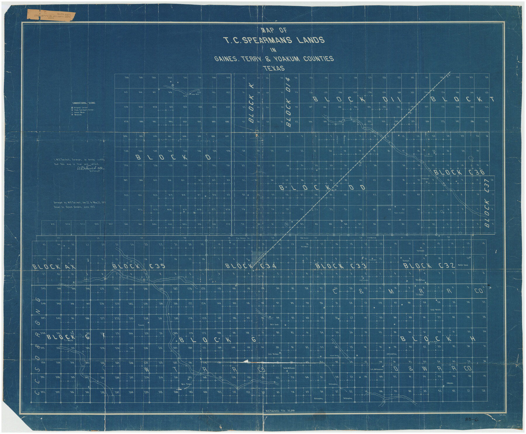
Map of T.C. Spearman's Lands in Gaines, Terry & Yoakum Counties, Texas
83-6
-
Map/Doc
89779
-
Collection
Twichell Survey Records
-
Object Dates
6/1917 (Creation Date)
-
People and Organizations
Sylvan Sanders (Draftsman)
W.D. Twichell (Surveyor/Engineer)
-
Counties
Gaines Terry Yoakum
-
Height x Width
44.9 x 37.0 inches
114.1 x 94.0 cm
Part of: Twichell Survey Records
[E. T. Ry. Blk. 1]
![89796, [E. T. Ry. Blk. 1], Twichell Survey Records](https://historictexasmaps.com/wmedia_w700/maps/89796-1.tif.jpg)
Print $40.00
- Digital $50.00
[E. T. Ry. Blk. 1]
Size 41.1 x 50.4 inches
Map/Doc 89796
H. W. Stanton's Subdivision of Northeast Quarter, Section 15, Block B

Print $20.00
- Digital $50.00
H. W. Stanton's Subdivision of Northeast Quarter, Section 15, Block B
Size 25.3 x 15.8 inches
Map/Doc 92788
Wichita County, State of Texas 1889

Print $20.00
- Digital $50.00
Wichita County, State of Texas 1889
1889
Size 44.3 x 32.6 inches
Map/Doc 89649
[I. & G. N. Block 1]
![93028, [I. & G. N. Block 1], Twichell Survey Records](https://historictexasmaps.com/wmedia_w700/maps/93028-1.tif.jpg)
Print $20.00
- Digital $50.00
[I. & G. N. Block 1]
Size 42.3 x 32.8 inches
Map/Doc 93028
College Park Addition to the City of Lubbock Located on Section 9, Block B

Print $20.00
- Digital $50.00
College Park Addition to the City of Lubbock Located on Section 9, Block B
Size 12.9 x 15.9 inches
Map/Doc 92277
[Ezekiel Ables and surrounding surveys]
![90966, [Ezekiel Ables and surrounding surveys], Twichell Survey Records](https://historictexasmaps.com/wmedia_w700/maps/90966-1.tif.jpg)
Print $20.00
- Digital $50.00
[Ezekiel Ables and surrounding surveys]
Size 12.6 x 18.0 inches
Map/Doc 90966
[Blocks 242, 243, and 244]
![90999, [Blocks 242, 243, and 244], Twichell Survey Records](https://historictexasmaps.com/wmedia_w700/maps/90999-1.tif.jpg)
Print $2.00
- Digital $50.00
[Blocks 242, 243, and 244]
Size 9.2 x 14.8 inches
Map/Doc 90999
Blocks 14, 15, and 16, Capitol Syndicate Subdivision of Capitol Land Reservation Leagues

Print $20.00
- Digital $50.00
Blocks 14, 15, and 16, Capitol Syndicate Subdivision of Capitol Land Reservation Leagues
1908
Size 24.6 x 37.1 inches
Map/Doc 90736
[County map showing Texas State Capitol Land and surrounding areas]
![93141, [County map showing Texas State Capitol Land and surrounding areas], Twichell Survey Records](https://historictexasmaps.com/wmedia_w700/maps/93141-1.tif.jpg)
Print $40.00
- Digital $50.00
[County map showing Texas State Capitol Land and surrounding areas]
Size 51.5 x 66.7 inches
Map/Doc 93141
Crosbyton (Jeff Williams Plan)

Print $20.00
- Digital $50.00
Crosbyton (Jeff Williams Plan)
Size 26.0 x 18.2 inches
Map/Doc 92126
Scurry County Sketch Mineral Application No. 42315

Print $20.00
- Digital $50.00
Scurry County Sketch Mineral Application No. 42315
1950
Size 24.2 x 16.4 inches
Map/Doc 92926
[McLennan County School Land Leagues 3 and 4 and surrounding surveys/blocks]
![90434, [McLennan County School Land Leagues 3 and 4 and surrounding surveys/blocks], Twichell Survey Records](https://historictexasmaps.com/wmedia_w700/maps/90434-1.tif.jpg)
Print $20.00
- Digital $50.00
[McLennan County School Land Leagues 3 and 4 and surrounding surveys/blocks]
Size 12.0 x 14.8 inches
Map/Doc 90434
You may also like
Cass County Working Sketch 24

Print $20.00
- Digital $50.00
Cass County Working Sketch 24
1973
Size 35.6 x 27.7 inches
Map/Doc 67927
Cottle County Working Sketch 3

Print $20.00
- Digital $50.00
Cottle County Working Sketch 3
1900
Size 13.6 x 11.4 inches
Map/Doc 68313
Harris County Boundary File 3

Print $16.00
- Digital $50.00
Harris County Boundary File 3
Size 14.7 x 7.0 inches
Map/Doc 54298
McMullen County Working Sketch 17

Print $20.00
- Digital $50.00
McMullen County Working Sketch 17
1941
Size 35.1 x 21.8 inches
Map/Doc 70718
Navigation Maps of Gulf Intracoastal Waterway, Port Arthur to Brownsville, Texas

Print $4.00
- Digital $50.00
Navigation Maps of Gulf Intracoastal Waterway, Port Arthur to Brownsville, Texas
1951
Size 16.6 x 21.5 inches
Map/Doc 65440
Flight Mission No. DQO-8K, Frame 44, Galveston County

Print $20.00
- Digital $50.00
Flight Mission No. DQO-8K, Frame 44, Galveston County
1952
Size 18.5 x 22.3 inches
Map/Doc 85151
Working Sketch Carson County

Print $3.00
- Digital $50.00
Working Sketch Carson County
1907
Size 11.6 x 17.8 inches
Map/Doc 90224
Coke County Working Sketch 22

Print $20.00
- Digital $50.00
Coke County Working Sketch 22
1949
Size 21.7 x 27.7 inches
Map/Doc 68059
Garza County Sketch File E

Print $20.00
- Digital $50.00
Garza County Sketch File E
Size 16.0 x 15.7 inches
Map/Doc 11552
Map Showing Soash Lands in Castro, Lamb, and Hale Counties, Texas

Print $20.00
- Digital $50.00
Map Showing Soash Lands in Castro, Lamb, and Hale Counties, Texas
1907
Size 13.9 x 17.6 inches
Map/Doc 91000
McLennan County Sketch File 1b

Print $4.00
- Digital $50.00
McLennan County Sketch File 1b
Size 8.3 x 8.1 inches
Map/Doc 31228
Morris County Boundary File 1

Print $18.00
- Digital $50.00
Morris County Boundary File 1
Size 14.1 x 8.7 inches
Map/Doc 57473