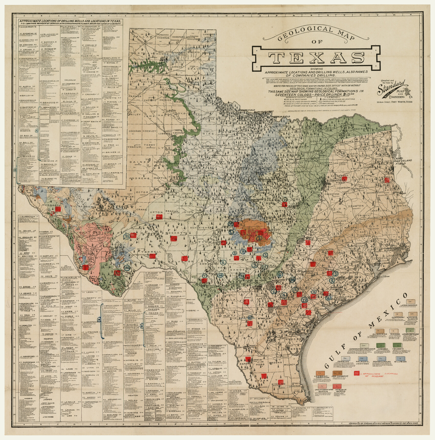
Geological map of Texas showing approximate locations and drilling wells. Also names of companies drilling
-
Map/Doc
93937
-
Collection
Rees-Jones Digital Map Collection
-
Object Dates
1920 (Creation Date)
-
People and Organizations
Standard Blue Print Map and Engineering (Publisher)
-
Subjects
State of Texas
-
Height x Width
26.9 x 26.6 inches
68.3 x 67.6 cm
-
Comments
Courtesy of the Rees-Jones Collection, Dallas, TX
Part of: Rees-Jones Digital Map Collection
Colton's Map of United States, the Canadas & c. showing the Railraods, Canals & Stage Roads with distances from place to place

Print $20.00
- Digital $50.00
Colton's Map of United States, the Canadas & c. showing the Railraods, Canals & Stage Roads with distances from place to place
Size 28.8 x 33.0 inches
Map/Doc 93983
Geological map of Texas showing approximate locations and drilling wells. Also names of companies drilling

Print $20.00
- Digital $50.00
Geological map of Texas showing approximate locations and drilling wells. Also names of companies drilling
1920
Size 26.9 x 26.6 inches
Map/Doc 93937
A new map of the states of Texas & California, the territories of Oregon, New Mexico, Utah, and the regions adjacent: compiled from the most recent authorities

Print $20.00
- Digital $50.00
A new map of the states of Texas & California, the territories of Oregon, New Mexico, Utah, and the regions adjacent: compiled from the most recent authorities
1851
Size 22.4 x 20.4 inches
Map/Doc 94051
Map of the Oregon Territory by the U.S. Ex. Ex.

Print $20.00
- Digital $50.00
Map of the Oregon Territory by the U.S. Ex. Ex.
1841
Size 26.2 x 37.3 inches
Map/Doc 94060
Kansas and Nebraska

Print $20.00
- Digital $50.00
Kansas and Nebraska
Size 30.8 x 19.4 inches
Map/Doc 93994
Nouvelle carte du Mexique, du Texas et d'une partie des États Limitrophes

Print $20.00
- Digital $50.00
Nouvelle carte du Mexique, du Texas et d'une partie des États Limitrophes
1834
Size 39.5 x 27.2 inches
Map/Doc 93764
A New Map of Texas with the Contiguous American & Mexican States

Print $20.00
- Digital $50.00
A New Map of Texas with the Contiguous American & Mexican States
1839
Size 13.5 x 16.1 inches
Map/Doc 93941
A map of the Anthracite Coal Fields of Pennsylvania embracing all of Schuylkill County and parts of Carbon, Luzerne, Columbia, Northumberland, Dauphin, and Lebanon Counties

Print $20.00
- Digital $50.00
A map of the Anthracite Coal Fields of Pennsylvania embracing all of Schuylkill County and parts of Carbon, Luzerne, Columbia, Northumberland, Dauphin, and Lebanon Counties
1863
Size 27.1 x 39.3 inches
Map/Doc 94054
Map of part of the island of Hawaii Sandwich Islands shewing the craters and eruption of May and June 1840 by the U.S. Ex. Ex.

Print $20.00
- Digital $50.00
Map of part of the island of Hawaii Sandwich Islands shewing the craters and eruption of May and June 1840 by the U.S. Ex. Ex.
1841
Size 18.4 x 25.9 inches
Map/Doc 94061
Colton's new map of the State of Texas, the Indian Territory and adjoining portions of New Mexico, Louisiana and Arkansas

Print $20.00
- Digital $50.00
Colton's new map of the State of Texas, the Indian Territory and adjoining portions of New Mexico, Louisiana and Arkansas
1874
Size 34.7 x 38.7 inches
Map/Doc 93762
Morley's Map of New Mexico compiled from the latest government surveys and other reliable sources

Print $20.00
- Digital $50.00
Morley's Map of New Mexico compiled from the latest government surveys and other reliable sources
1873
Size 26.2 x 28.0 inches
Map/Doc 94052
Map of Texas comprising the grant of the Texian Emigration and Land-Company

Print $20.00
- Digital $50.00
Map of Texas comprising the grant of the Texian Emigration and Land-Company
1843
Size 9.4 x 10.1 inches
Map/Doc 94049
You may also like
Flight Mission No. CZW-1R, Frame 116, Hardeman County

Print $20.00
- Digital $50.00
Flight Mission No. CZW-1R, Frame 116, Hardeman County
1956
Size 18.6 x 19.0 inches
Map/Doc 85235
Bee County Working Sketch 11

Print $20.00
- Digital $50.00
Bee County Working Sketch 11
1942
Size 19.8 x 24.4 inches
Map/Doc 67261

Motley County Sketch File 7a (N)

Print $40.00
- Digital $50.00
Motley County Sketch File 7a (N)
1895
Size 13.5 x 14.4 inches
Map/Doc 32014
Flight Mission No. DAH-9M, Frame 157, Orange County

Print $20.00
- Digital $50.00
Flight Mission No. DAH-9M, Frame 157, Orange County
1953
Size 18.5 x 22.5 inches
Map/Doc 86856
Callahan County Working Sketch 14

Print $20.00
- Digital $50.00
Callahan County Working Sketch 14
2010
Size 25.8 x 23.7 inches
Map/Doc 89273
Presidio County Rolled Sketch 58

Print $20.00
- Digital $50.00
Presidio County Rolled Sketch 58
Size 26.1 x 36.6 inches
Map/Doc 7351
Brewster County Working Sketch 92

Print $40.00
- Digital $50.00
Brewster County Working Sketch 92
1975
Size 61.9 x 39.4 inches
Map/Doc 67692
Tarrant County Working Sketch 15

Print $20.00
- Digital $50.00
Tarrant County Working Sketch 15
1989
Size 33.0 x 38.3 inches
Map/Doc 62432
Zavala County Sketch File 4

Print $20.00
- Digital $50.00
Zavala County Sketch File 4
1852
Size 17.7 x 14.7 inches
Map/Doc 12726
[West line of H. & T. C. Block 97]
![90210, [West line of H. & T. C. Block 97], Twichell Survey Records](https://historictexasmaps.com/wmedia_w700/maps/90210-1.tif.jpg)
Print $20.00
- Digital $50.00
[West line of H. & T. C. Block 97]
Size 19.7 x 35.1 inches
Map/Doc 90210
San Patricio County Rolled Sketch 46

Print $20.00
- Digital $50.00
San Patricio County Rolled Sketch 46
1983
Size 19.6 x 25.5 inches
Map/Doc 7730