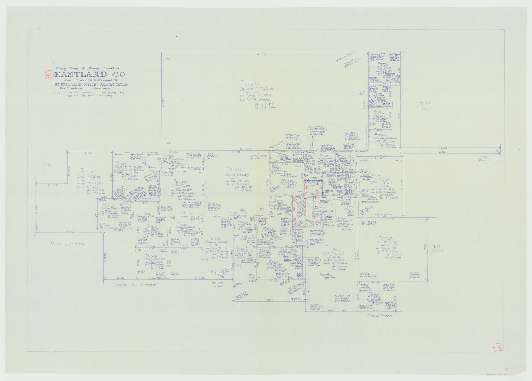
Eastland County Working Sketch 45
-
Map/Doc
68826
-
Collection
General Map Collection
-
Object Dates
11/29/1979 (Creation Date)
-
People and Organizations
Joan Kilpatrick (Draftsman)
-
Counties
Eastland
-
Subjects
Surveying Working Sketch
-
Height x Width
31.3 x 43.7 inches
79.5 x 111.0 cm
-
Scale
1" = 360 varas
Part of: General Map Collection
Map of the Southwest Railway System

Print $20.00
- Digital $50.00
Map of the Southwest Railway System
1883
Size 16.0 x 28.8 inches
Map/Doc 93287
Flight Mission No. CRC-4R, Frame 160, Chambers County

Print $20.00
- Digital $50.00
Flight Mission No. CRC-4R, Frame 160, Chambers County
1956
Size 18.5 x 22.3 inches
Map/Doc 84919
Map of Wilson County

Print $20.00
- Digital $50.00
Map of Wilson County
1879
Size 23.0 x 24.4 inches
Map/Doc 4157
Shelby County Working Sketch 12

Print $40.00
- Digital $50.00
Shelby County Working Sketch 12
1946
Size 53.4 x 36.4 inches
Map/Doc 63865
Johnson County Boundary File 51b

Print $80.00
- Digital $50.00
Johnson County Boundary File 51b
Size 53.9 x 9.4 inches
Map/Doc 55619
New Map of San Antonio, Texas

Print $20.00
- Digital $50.00
New Map of San Antonio, Texas
1920
Size 17.2 x 14.2 inches
Map/Doc 97156
Terrell County Working Sketch 15

Print $20.00
- Digital $50.00
Terrell County Working Sketch 15
1927
Size 18.7 x 19.8 inches
Map/Doc 62164
Clay County Boundary File 5

Print $6.00
- Digital $50.00
Clay County Boundary File 5
Size 11.1 x 8.5 inches
Map/Doc 51373
Lubbock County

Print $20.00
- Digital $50.00
Lubbock County
1915
Size 46.1 x 40.0 inches
Map/Doc 66911
Flight Mission No. BQY-4M, Frame 34, Harris County

Print $20.00
- Digital $50.00
Flight Mission No. BQY-4M, Frame 34, Harris County
1953
Size 18.6 x 22.4 inches
Map/Doc 85249
Flight Mission No. CRC-2R, Frame 122, Chambers County

Print $20.00
- Digital $50.00
Flight Mission No. CRC-2R, Frame 122, Chambers County
1956
Size 18.9 x 22.5 inches
Map/Doc 84746
[Sketch for Mineral Application 17237 / Mineral File 11855 - Neches River, Joe A. Sanders]
![2819, [Sketch for Mineral Application 17237 / Mineral File 11855 - Neches River, Joe A. Sanders], General Map Collection](https://historictexasmaps.com/wmedia_w700/maps/2819.tif.jpg)
Print $2.00
- Digital $50.00
[Sketch for Mineral Application 17237 / Mineral File 11855 - Neches River, Joe A. Sanders]
1927
Size 12.8 x 8.2 inches
Map/Doc 2819
You may also like
Terrell County Rolled Sketch 44

Print $20.00
- Digital $50.00
Terrell County Rolled Sketch 44
1952
Size 18.3 x 22.9 inches
Map/Doc 7947
Foard County Sketch File 18

Print $6.00
- Digital $50.00
Foard County Sketch File 18
1888
Size 13.0 x 8.5 inches
Map/Doc 22834
[Topographical Map showing part of Miller Day Ranch in Southwest Part of Coleman County]
![81515, [Topographical Map showing part of Miller Day Ranch in Southwest Part of Coleman County], General Map Collection](https://historictexasmaps.com/wmedia_w700/maps/81515.tif.jpg)
Print $3.00
- Digital $50.00
[Topographical Map showing part of Miller Day Ranch in Southwest Part of Coleman County]
Size 11.3 x 17.3 inches
Map/Doc 81515
Map of Martin County

Print $20.00
- Digital $50.00
Map of Martin County
1900
Size 41.9 x 35.0 inches
Map/Doc 4789
Hamilton County Working Sketch 5

Print $20.00
- Digital $50.00
Hamilton County Working Sketch 5
1941
Size 25.5 x 20.1 inches
Map/Doc 63343
Webb County Working Sketch 80

Print $40.00
- Digital $50.00
Webb County Working Sketch 80
1979
Size 43.0 x 97.9 inches
Map/Doc 72447
Greater Texas and the Coast Country - The Winter Garden

Greater Texas and the Coast Country - The Winter Garden
1911
Size 9.4 x 4.5 inches
Map/Doc 97057
Brazoria County Working Sketch 20

Print $40.00
- Digital $50.00
Brazoria County Working Sketch 20
1951
Size 50.3 x 42.9 inches
Map/Doc 67505
Current Miscellaneous File 39

Print $20.00
- Digital $50.00
Current Miscellaneous File 39
Size 11.2 x 8.8 inches
Map/Doc 73962
Blanco County Sketch File 21b

Print $40.00
- Digital $50.00
Blanco County Sketch File 21b
1882
Size 16.9 x 17.8 inches
Map/Doc 10930

San Patricio County Rolled Sketch 27B

Print $40.00
- Digital $50.00
San Patricio County Rolled Sketch 27B
Size 50.3 x 38.4 inches
Map/Doc 9892