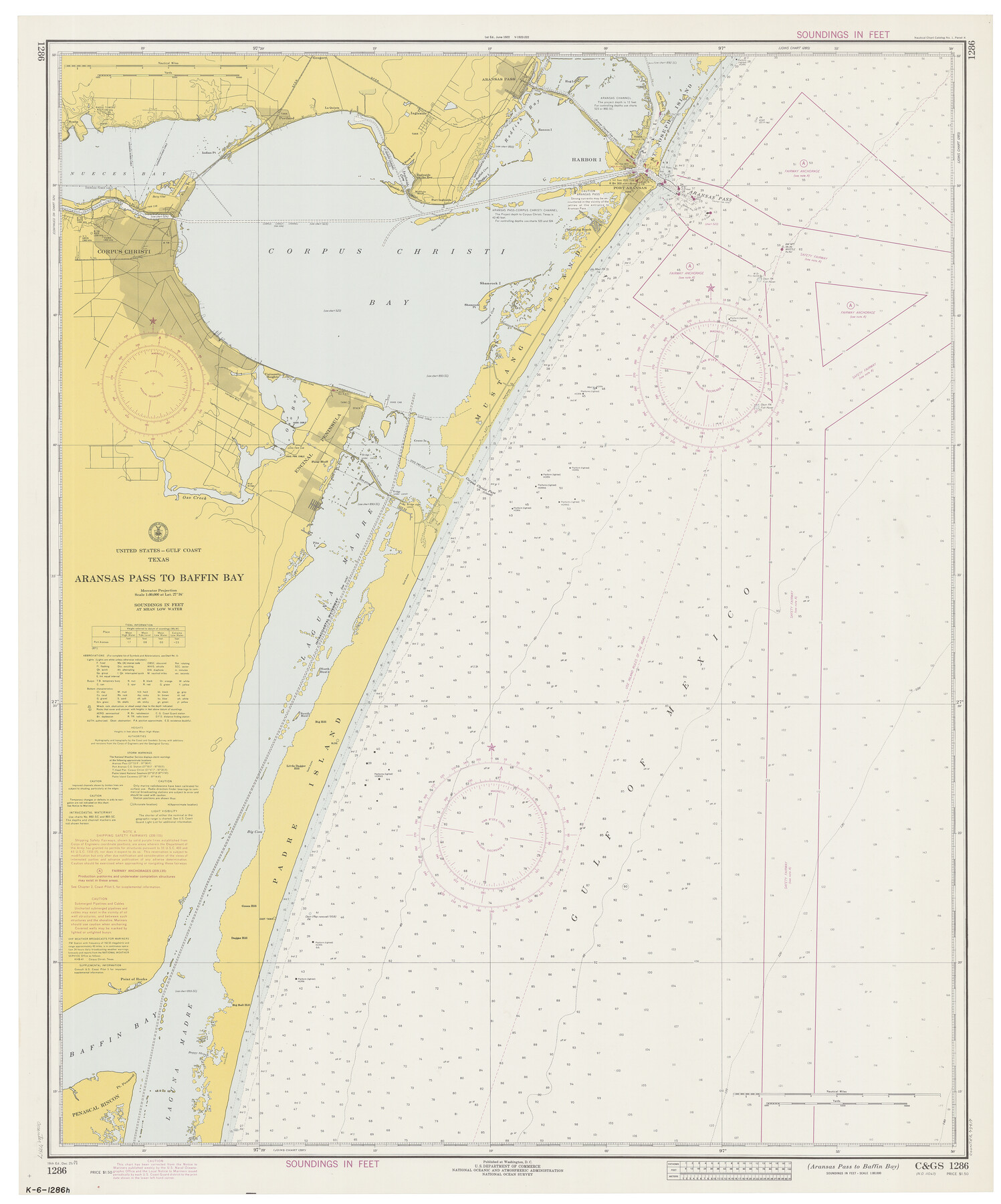
Aransas Pass to Baffin Bay
-
Map/Doc
73417
-
Collection
General Map Collection
-
Object Dates
12/25/1971 (Creation Date)
-
Counties
Aransas San Patricio Nueces Kleberg Kenedy
-
Subjects
Nautical Charts
-
Height x Width
42.3 x 35.2 inches
107.4 x 89.4 cm
Part of: General Map Collection
Colorado County Working Sketch 10

Print $20.00
- Digital $50.00
Colorado County Working Sketch 10
1940
Size 23.2 x 24.4 inches
Map/Doc 68110
Stonewall County Working Sketch 11

Print $20.00
- Digital $50.00
Stonewall County Working Sketch 11
1950
Size 23.8 x 33.7 inches
Map/Doc 62318
Map of Coryell Co.

Print $40.00
- Digital $50.00
Map of Coryell Co.
1896
Size 48.0 x 46.2 inches
Map/Doc 66786
Hidalgo County Sketch File 10

Print $20.00
- Digital $50.00
Hidalgo County Sketch File 10
1911
Size 16.3 x 34.8 inches
Map/Doc 11762
Hardeman County Working Sketch 9

Print $20.00
- Digital $50.00
Hardeman County Working Sketch 9
1953
Size 44.4 x 27.2 inches
Map/Doc 63390
DeWitt County Sketch File 9

Print $22.00
- Digital $50.00
DeWitt County Sketch File 9
1878
Size 5.6 x 5.9 inches
Map/Doc 20820
Dawson County Sketch File 10

Print $4.00
- Digital $50.00
Dawson County Sketch File 10
1927
Size 11.4 x 8.8 inches
Map/Doc 20544
Atascosa County Working Sketch 30

Print $20.00
- Digital $50.00
Atascosa County Working Sketch 30
1980
Size 16.4 x 20.6 inches
Map/Doc 67226
East Part of Brewster Co.

Print $40.00
- Digital $50.00
East Part of Brewster Co.
1952
Size 49.5 x 31.1 inches
Map/Doc 95436
Tom Green County Sketch File 39

Print $40.00
- Digital $50.00
Tom Green County Sketch File 39
1881
Size 14.8 x 18.6 inches
Map/Doc 76002
Refugio County Boundary File 2

Print $32.00
- Digital $50.00
Refugio County Boundary File 2
Size 14.1 x 8.8 inches
Map/Doc 58233
Crane County Working Sketch 17

Print $40.00
- Digital $50.00
Crane County Working Sketch 17
1957
Size 121.8 x 50.0 inches
Map/Doc 68294
You may also like
McLennan County Sketch File 2

Print $6.00
- Digital $50.00
McLennan County Sketch File 2
1856
Size 11.5 x 7.7 inches
Map/Doc 31230
Official Map, City of Lubbock, Lubbock County, Texas

Print $20.00
- Digital $50.00
Official Map, City of Lubbock, Lubbock County, Texas
1927
Size 24.1 x 32.9 inches
Map/Doc 91329
Edwards County Working Sketch 99

Print $20.00
- Digital $50.00
Edwards County Working Sketch 99
1970
Size 36.3 x 27.9 inches
Map/Doc 68975
Jefferson County Rolled Sketch 57

Print $20.00
- Digital $50.00
Jefferson County Rolled Sketch 57
1883
Size 25.9 x 18.6 inches
Map/Doc 6407
Webb County Rolled Sketch 65

Print $20.00
- Digital $50.00
Webb County Rolled Sketch 65
1949
Size 37.1 x 24.3 inches
Map/Doc 8214
Map of Anderson County

Print $20.00
- Digital $50.00
Map of Anderson County
1876
Size 19.4 x 21.9 inches
Map/Doc 3228
Hardeman County Sketch File A3

Print $4.00
- Digital $50.00
Hardeman County Sketch File A3
1890
Size 14.2 x 8.8 inches
Map/Doc 25052
La Salle County Rolled Sketch 30

Print $20.00
- Digital $50.00
La Salle County Rolled Sketch 30
Size 30.1 x 40.8 inches
Map/Doc 6590
[Sketch for Mineral Application 1112 - Colorado River, H. E. Chambers]
![65642, [Sketch for Mineral Application 1112 - Colorado River, H. E. Chambers], General Map Collection](https://historictexasmaps.com/wmedia_w700/maps/65642.tif.jpg)
Print $20.00
- Digital $50.00
[Sketch for Mineral Application 1112 - Colorado River, H. E. Chambers]
1918
Size 17.1 x 28.4 inches
Map/Doc 65642
Map of Texas and Adjacent Regions in the Eighteenth Century

Print $20.00
Map of Texas and Adjacent Regions in the Eighteenth Century
1915
Size 19.3 x 23.3 inches
Map/Doc 79743

[Texas Boundary Line]
![92080, [Texas Boundary Line], Twichell Survey Records](https://historictexasmaps.com/wmedia_w700/maps/92080-1.tif.jpg)
Print $20.00
- Digital $50.00
[Texas Boundary Line]
Size 21.7 x 12.1 inches
Map/Doc 92080