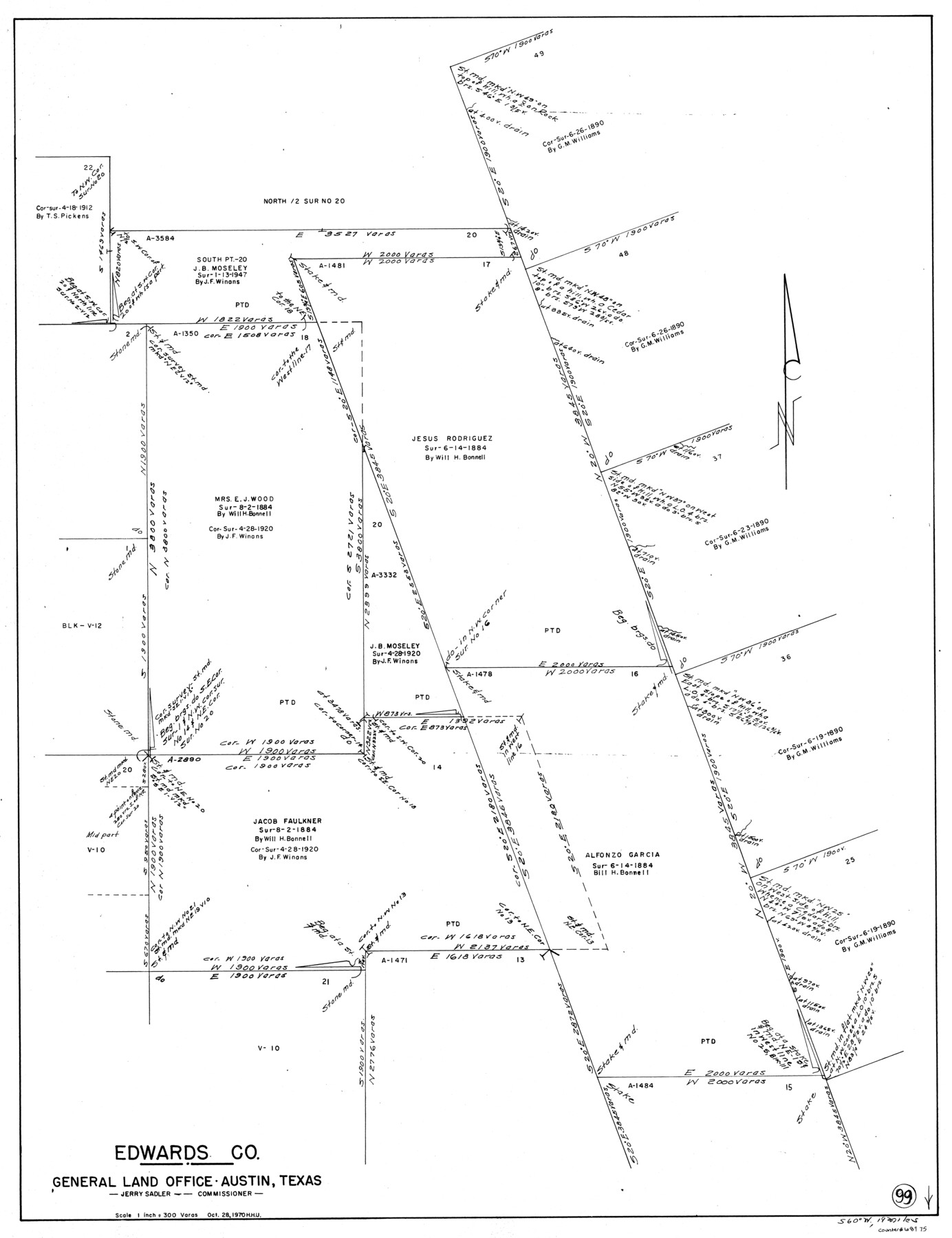
Edwards County Working Sketch 99
-
Map/Doc
68975
-
Collection
General Map Collection
-
Object Dates
10/28/1970 (Creation Date)
-
People and Organizations
Herbert H. Ulbricht (Draftsman)
-
Counties
Edwards
-
Subjects
Surveying Working Sketch
-
Height x Width
36.3 x 27.9 inches
92.2 x 70.9 cm
-
Scale
1" = 300 varas
Part of: General Map Collection
Frio County Rolled Sketch 8

Print $20.00
- Digital $50.00
Frio County Rolled Sketch 8
1940
Size 19.1 x 36.0 inches
Map/Doc 8901
Pecos County Working Sketch 68

Print $20.00
- Digital $50.00
Pecos County Working Sketch 68
1955
Size 41.4 x 24.0 inches
Map/Doc 71540
Matagorda County Sketch File 43

Print $20.00
- Digital $50.00
Matagorda County Sketch File 43
1839
Size 13.2 x 8.2 inches
Map/Doc 30868
Live Oak County Working Sketch 11

Print $20.00
- Digital $50.00
Live Oak County Working Sketch 11
1949
Size 29.7 x 25.7 inches
Map/Doc 70596
Starr County Sketch File 48a

Print $40.00
- Digital $50.00
Starr County Sketch File 48a
1950
Size 9.0 x 22.0 inches
Map/Doc 37005
Dallas County Sketch File 19

Print $20.00
- Digital $50.00
Dallas County Sketch File 19
Size 17.1 x 17.9 inches
Map/Doc 11287
Maverick County Boundary File 1

Print $48.00
- Digital $50.00
Maverick County Boundary File 1
Size 14.2 x 8.7 inches
Map/Doc 56901
Wichita County Sketch File 18

Print $6.00
- Digital $50.00
Wichita County Sketch File 18
1890
Size 14.0 x 8.6 inches
Map/Doc 40099

Map of part of the State of Texas

Print $3.00
- Digital $50.00
Map of part of the State of Texas
1857
Size 8.0 x 9.6 inches
Map/Doc 95363
Presidio County Sketch File 59

Print $12.00
- Digital $50.00
Presidio County Sketch File 59
1935
Size 8.7 x 7.5 inches
Map/Doc 34637
Fannin County Sketch File 17

Print $22.00
- Digital $50.00
Fannin County Sketch File 17
1874
Size 8.0 x 12.9 inches
Map/Doc 22471
You may also like
The Republic County of Jasper. December 29, 1845

Print $20.00
The Republic County of Jasper. December 29, 1845
2020
Size 19.5 x 21.7 inches
Map/Doc 96196
Marion County

Print $20.00
- Digital $50.00
Marion County
1943
Size 30.3 x 47.9 inches
Map/Doc 95579
Haskell County Sketch File 16

Print $32.00
- Digital $50.00
Haskell County Sketch File 16
1894
Size 11.2 x 8.8 inches
Map/Doc 26163
Hill County Working Sketch 1

Print $20.00
- Digital $50.00
Hill County Working Sketch 1
1939
Size 11.0 x 17.8 inches
Map/Doc 66187
The History of the Republic of Texas, from the discovery of the country to the present time; and the cause of her separation from the Republic of Mexico.

Print $1080.00
- Digital $50.00
The History of the Republic of Texas, from the discovery of the country to the present time; and the cause of her separation from the Republic of Mexico.
1842
Size 9.3 x 6.1 inches
Map/Doc 93866
Wharton County Sketch File A3

Print $26.00
- Digital $50.00
Wharton County Sketch File A3
1899
Size 18.2 x 18.6 inches
Map/Doc 12671
2008 Official Travel Map Texas

Digital $50.00
2008 Official Travel Map Texas
Size 33.4 x 36.5 inches
Map/Doc 94310
General Highway Map, Terry County, Texas

Print $20.00
General Highway Map, Terry County, Texas
1961
Size 18.1 x 24.9 inches
Map/Doc 79675
Dimmit County Sketch File 31

Print $20.00
- Digital $50.00
Dimmit County Sketch File 31
1894
Size 12.7 x 17.3 inches
Map/Doc 11352
Flight Mission No. DIX-6P, Frame 129, Aransas County

Print $20.00
- Digital $50.00
Flight Mission No. DIX-6P, Frame 129, Aransas County
1956
Size 18.9 x 22.4 inches
Map/Doc 83835
Eastland County Working Sketch 16

Print $20.00
- Digital $50.00
Eastland County Working Sketch 16
1919
Size 19.1 x 16.7 inches
Map/Doc 68797
Gray County Sketch File 6

Print $20.00
- Digital $50.00
Gray County Sketch File 6
1882
Size 26.3 x 21.4 inches
Map/Doc 11575