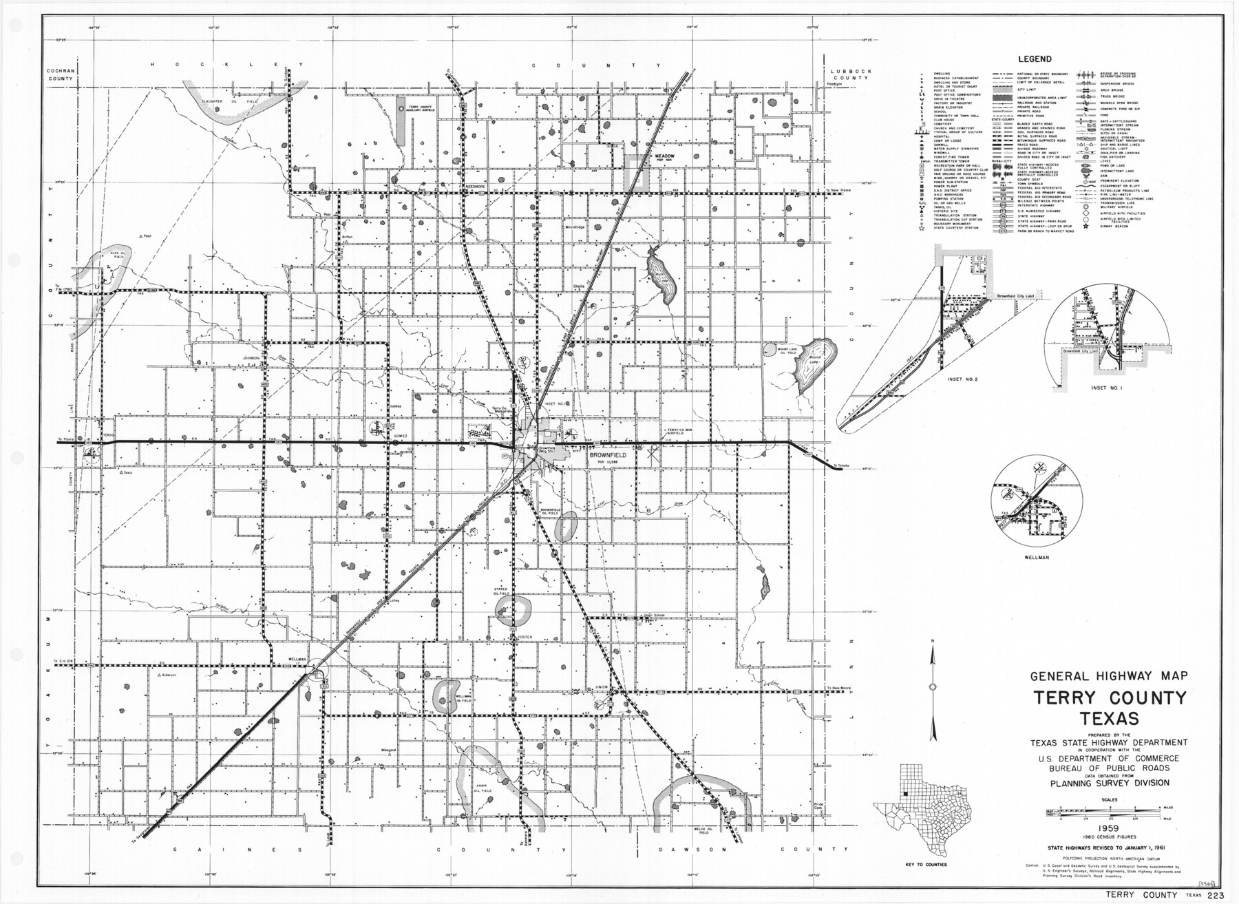
General Highway Map, Terry County, Texas
-
Map/Doc
79675
-
Collection
Texas State Library and Archives
-
Object Dates
1961 (Creation Date)
-
People and Organizations
Texas State Highway Department (Publisher)
-
Counties
Terry
-
Subjects
County
-
Height x Width
18.1 x 24.9 inches
46.0 x 63.3 cm
-
Comments
Prints available courtesy of the Texas State Library and Archives.
More info can be found here: TSLAC Map 05305
Part of: Texas State Library and Archives
Revised Edition of Murphy and Bolanz Official Map of the City of Dallas and Suburbs

Print $20.00
Revised Edition of Murphy and Bolanz Official Map of the City of Dallas and Suburbs
1891
Size 38.1 x 30.8 inches
Map/Doc 76275
General Highway Map, Walker County, Texas

Print $20.00
General Highway Map, Walker County, Texas
1961
Size 24.7 x 18.1 inches
Map/Doc 79698
General Highway Map, Upshur County, Gregg County, Texas

Print $20.00
General Highway Map, Upshur County, Gregg County, Texas
1939
Size 24.9 x 18.6 inches
Map/Doc 79105
General Highway Map, McCulloch County, Texas

Print $20.00
General Highway Map, McCulloch County, Texas
1940
Size 24.6 x 18.2 inches
Map/Doc 79190
General Highway Map, Grimes County, Texas

Print $20.00
General Highway Map, Grimes County, Texas
1940
Size 25.0 x 18.4 inches
Map/Doc 79106
General Highway Map, Zapata County, Texas

Print $20.00
General Highway Map, Zapata County, Texas
1940
Size 18.4 x 24.8 inches
Map/Doc 79287
General Highway Map, Yoakum County, Texas

Print $20.00
General Highway Map, Yoakum County, Texas
1961
Size 18.2 x 24.7 inches
Map/Doc 79719
General Highway Map. Detail of Cities and Towns in Tom Green County, Texas. City Map, San Angelo, Tom Green County, Texas

Print $20.00
General Highway Map. Detail of Cities and Towns in Tom Green County, Texas. City Map, San Angelo, Tom Green County, Texas
1961
Size 18.1 x 24.8 inches
Map/Doc 79679
Rand McNally Main Highway Map of Texas

Print $20.00
Rand McNally Main Highway Map of Texas
1923
Size 27.7 x 40.3 inches
Map/Doc 76260
General Highway Map, Coleman County, Texas

Print $20.00
General Highway Map, Coleman County, Texas
1961
Size 24.6 x 18.3 inches
Map/Doc 79412
General Highway Map, Henderson County, Texas

Print $20.00
General Highway Map, Henderson County, Texas
1939
Size 18.3 x 25.0 inches
Map/Doc 79125
Principal Highways of the Southwest with particular reference to New Mexico, Oklahoma, Texas, Arkansas and Louisiana

Print $20.00
Principal Highways of the Southwest with particular reference to New Mexico, Oklahoma, Texas, Arkansas and Louisiana
1933
Size 24.3 x 18.4 inches
Map/Doc 76302
You may also like
Nueces County Rolled Sketch 43

Print $20.00
- Digital $50.00
Nueces County Rolled Sketch 43
Size 23.6 x 31.8 inches
Map/Doc 6883
Jefferson County NRC Article 33.136 Location Key Sheet

Print $20.00
- Digital $50.00
Jefferson County NRC Article 33.136 Location Key Sheet
1970
Size 27.0 x 23.0 inches
Map/Doc 82995
[Beaumont, Sour Lake and Western Ry. Right of Way and Alignment - Frisco]
![64132, [Beaumont, Sour Lake and Western Ry. Right of Way and Alignment - Frisco], General Map Collection](https://historictexasmaps.com/wmedia_w700/maps/64132.tif.jpg)
Print $20.00
- Digital $50.00
[Beaumont, Sour Lake and Western Ry. Right of Way and Alignment - Frisco]
1910
Size 19.9 x 46.1 inches
Map/Doc 64132
Eastland County Working Sketch 40

Print $20.00
- Digital $50.00
Eastland County Working Sketch 40
1970
Size 27.9 x 26.0 inches
Map/Doc 68821
Flight Mission No. BRA-17M, Frame 17, Jefferson County

Print $20.00
- Digital $50.00
Flight Mission No. BRA-17M, Frame 17, Jefferson County
1953
Size 18.5 x 22.3 inches
Map/Doc 85798
Wise County Sketch File 40

Print $4.00
- Digital $50.00
Wise County Sketch File 40
1875
Size 8.0 x 10.6 inches
Map/Doc 40597
Stonewall County Sketch File 25

Print $7.00
- Digital $50.00
Stonewall County Sketch File 25
1952
Size 26.7 x 43.3 inches
Map/Doc 10375
Presidio County Rolled Sketch MS

Print $20.00
- Digital $50.00
Presidio County Rolled Sketch MS
Size 35.9 x 19.0 inches
Map/Doc 7412
General Highway Map, Kleberg County, Texas

Print $20.00
General Highway Map, Kleberg County, Texas
1961
Size 24.6 x 18.3 inches
Map/Doc 79559
Floyd County Working Sketch 8

Print $20.00
- Digital $50.00
Floyd County Working Sketch 8
1931
Size 20.8 x 15.9 inches
Map/Doc 69187
General Highway Map, McCulloch County, Texas
Print $20.00
General Highway Map, McCulloch County, Texas
1940
Size 24.6 x 18.2 inches
Map/Doc 79190
Kimble County Sketch File 42

Print $10.00
- Digital $50.00
Kimble County Sketch File 42
1995
Size 11.2 x 8.8 inches
Map/Doc 29015