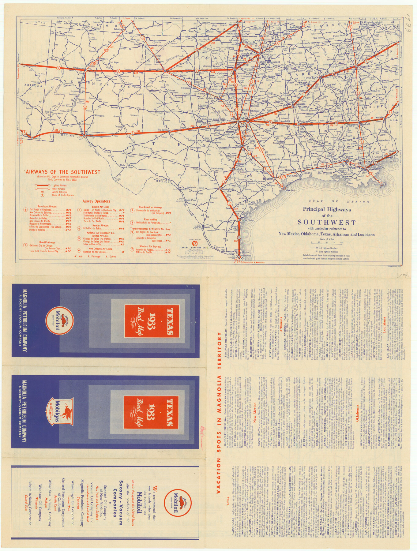
Principal Highways of the Southwest with particular reference to New Mexico, Oklahoma, Texas, Arkansas and Louisiana
-
Map/Doc
76302
-
Collection
Texas State Library and Archives
-
Object Dates
1933 (Creation Date)
-
People and Organizations
General Drafting Company, Inc. (Publisher)
-
Subjects
New Southwest State of Texas
-
Height x Width
24.3 x 18.4 inches
61.7 x 46.7 cm
-
Comments
Prints available courtesy of the Texas State Library and Archives.
More info can be found here: TSLAC Map 06407
Part of: Texas State Library and Archives
General Highway Map, DeWitt County, Texas

Print $20.00
General Highway Map, DeWitt County, Texas
1961
Size 18.3 x 24.5 inches
Map/Doc 79442
General Highway Map. Detail of Cities and Towns in Navarro County, Texas

Print $20.00
General Highway Map. Detail of Cities and Towns in Navarro County, Texas
1961
Size 19.3 x 25.0 inches
Map/Doc 79611
General Highway Map, Marion County, Texas

Print $20.00
General Highway Map, Marion County, Texas
1940
Size 18.3 x 24.7 inches
Map/Doc 79184
General Highway Map, Brewster County, Texas

Print $20.00
General Highway Map, Brewster County, Texas
1961
Size 18.2 x 24.9 inches
Map/Doc 79385
Map of Texas. The Proposed Reoccupation of the Rio Grande -- Its Importance to the Union

Print $20.00
Map of Texas. The Proposed Reoccupation of the Rio Grande -- Its Importance to the Union
1863
Size 14.1 x 8.7 inches
Map/Doc 76263
Reconnoissances of Routes from San Antonio de Bexar to El Paso Del Norte

Print $20.00
Reconnoissances of Routes from San Antonio de Bexar to El Paso Del Norte
1849
Size 27.5 x 39.6 inches
Map/Doc 76239
General Highway Map. Detail of Cities and Towns in Travis County, Texas

Print $20.00
General Highway Map. Detail of Cities and Towns in Travis County, Texas
1961
Size 18.1 x 24.7 inches
Map/Doc 79683
General Highway Map, Colorado County, Texas

Print $20.00
General Highway Map, Colorado County, Texas
1940
Size 25.1 x 18.5 inches
Map/Doc 79054
Carte Reduite des Costes de la Louisiane et de la Floride

Print $20.00
Carte Reduite des Costes de la Louisiane et de la Floride
1764
Size 23.3 x 35.1 inches
Map/Doc 79295
Carte du Mexique ou de la Nouvelle Espagne

Print $20.00
Carte du Mexique ou de la Nouvelle Espagne
1750
Size 12.4 x 15.5 inches
Map/Doc 79741
General Highway Map, Dallam County, Texas

Print $20.00
General Highway Map, Dallam County, Texas
1961
Size 24.6 x 18.3 inches
Map/Doc 79428
General Highway Map, Dawson County, Texas

Print $20.00
General Highway Map, Dawson County, Texas
1940
Size 18.5 x 25.2 inches
Map/Doc 79071
You may also like
Terrell County Rolled Sketch 37

Print $20.00
- Digital $50.00
Terrell County Rolled Sketch 37
1940
Size 23.8 x 33.3 inches
Map/Doc 7941
Taylor County Working Sketch 22

Print $40.00
- Digital $50.00
Taylor County Working Sketch 22
1985
Size 50.3 x 37.3 inches
Map/Doc 69632
Dawson County, Texas

Print $20.00
- Digital $50.00
Dawson County, Texas
1880
Size 28.6 x 20.5 inches
Map/Doc 705
Scurry County Working Sketch 8

Print $40.00
- Digital $50.00
Scurry County Working Sketch 8
1980
Size 34.5 x 49.5 inches
Map/Doc 63837
Map of Hale County

Print $20.00
- Digital $50.00
Map of Hale County
1900
Size 47.8 x 38.6 inches
Map/Doc 66847
The Chief Justice County of Bexar. May 1, 1837

Print $20.00
The Chief Justice County of Bexar. May 1, 1837
2020
Size 25.4 x 21.6 inches
Map/Doc 96038
McClennan County

Print $20.00
- Digital $50.00
McClennan County
1880
Size 23.6 x 25.4 inches
Map/Doc 4596
Jeff Davis County Sketch File 35

Print $20.00
- Digital $50.00
Jeff Davis County Sketch File 35
1950
Size 20.6 x 19.2 inches
Map/Doc 11866
Aransas County Rolled Sketch 12

Print $20.00
- Digital $50.00
Aransas County Rolled Sketch 12
Size 17.6 x 11.1 inches
Map/Doc 77191
PSL Field Notes for Blocks B13, B18, and B28 in Crane and Ward Counties, and Blocks B19, B20, and B29 in Ward County

PSL Field Notes for Blocks B13, B18, and B28 in Crane and Ward Counties, and Blocks B19, B20, and B29 in Ward County
Map/Doc 81647
Winkler County Sketch File 6

Print $22.00
- Digital $50.00
Winkler County Sketch File 6
1927
Size 4.4 x 9.8 inches
Map/Doc 40475
Pecos County Rolled Sketch 126

Print $20.00
- Digital $50.00
Pecos County Rolled Sketch 126
1948
Size 42.5 x 38.4 inches
Map/Doc 9724