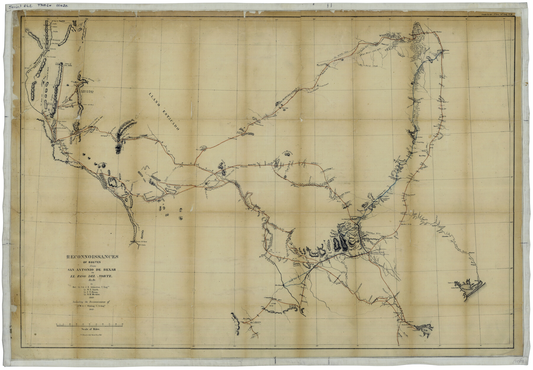
Reconnoissances of Routes from San Antonio de Bexar to El Paso Del Norte
-
Map/Doc
76239
-
Collection
Texas State Library and Archives
-
Object Dates
1849 (Creation Date)
-
People and Organizations
W.H.C. Whiting (Surveyor/Engineer)
J.E. Johnston (Surveyor/Engineer)
W.F. Smith (Surveyor/Engineer)
F.T. Bryan (Surveyor/Engineer)
N.H. Michler (Surveyor/Engineer)
-
Subjects
Military
-
Height x Width
27.5 x 39.6 inches
69.9 x 100.6 cm
-
Comments
Prints available courtesy of the Texas State Library and Archives.
More info can be found here: TSLAC Map 01529
Part of: Texas State Library and Archives
General Highway Map, Panola County, Texas

Print $20.00
General Highway Map, Panola County, Texas
1961
Size 18.1 x 24.5 inches
Map/Doc 79624
General Highway Map, Henderson County, Texas

Print $20.00
General Highway Map, Henderson County, Texas
1961
Size 24.9 x 18.0 inches
Map/Doc 79517
General Highway Map, Angelina County, Texas

Print $20.00
General Highway Map, Angelina County, Texas
1940
Size 18.5 x 24.9 inches
Map/Doc 79003
General Highway Map, Harrison County, Texas

Print $20.00
General Highway Map, Harrison County, Texas
1940
Size 18.2 x 24.8 inches
Map/Doc 79121
General Highway Map, Dallam County, Hartley County, Texas

Print $20.00
General Highway Map, Dallam County, Hartley County, Texas
1940
Size 18.3 x 25.1 inches
Map/Doc 79065
[General Highway Map of] Bexar County, Sheet 1 of 2
![76288, [General Highway Map of] Bexar County, Sheet 1 of 2, Texas State Library and Archives](https://historictexasmaps.com/wmedia_w700/maps/76288.tif.jpg)
Print $20.00
[General Highway Map of] Bexar County, Sheet 1 of 2
1940
Size 18.5 x 25.1 inches
Map/Doc 76288
General Highway Map, Cherokee County, Texas

Print $20.00
General Highway Map, Cherokee County, Texas
1961
Size 18.2 x 24.6 inches
Map/Doc 79405
General Highway Map, Hamilton County, Texas

Print $20.00
General Highway Map, Hamilton County, Texas
1940
Size 18.4 x 24.9 inches
Map/Doc 79111
General Highway Map, Franklin County, Texas

Print $20.00
General Highway Map, Franklin County, Texas
1961
Size 18.1 x 24.5 inches
Map/Doc 79471
General Highway Map. Detail of Cities and Towns in Dallas County, Texas [Dallas and vicinity]
![79068, General Highway Map. Detail of Cities and Towns in Dallas County, Texas [Dallas and vicinity], Texas State Library and Archives](https://historictexasmaps.com/wmedia_w700/maps/79068.tif.jpg)
Print $20.00
General Highway Map. Detail of Cities and Towns in Dallas County, Texas [Dallas and vicinity]
1936
Size 18.5 x 25.2 inches
Map/Doc 79068
General Highway Map, Starr County, Texas

Print $20.00
General Highway Map, Starr County, Texas
1961
Size 24.9 x 18.1 inches
Map/Doc 79658
J. De Cordova's Map of the State of Texas Compiled from the records of the General Land Office of the State

Print $20.00
J. De Cordova's Map of the State of Texas Compiled from the records of the General Land Office of the State
1856
Size 34.2 x 32.1 inches
Map/Doc 76222
You may also like
Little River, Reeds Lake Sheet

Print $6.00
- Digital $50.00
Little River, Reeds Lake Sheet
1927
Size 31.8 x 28.1 inches
Map/Doc 65066
Kimble County Working Sketch 4

Print $20.00
- Digital $50.00
Kimble County Working Sketch 4
1913
Size 26.8 x 21.7 inches
Map/Doc 70072
Flight Mission No. BRE-1P, Frame 78, Nueces County

Print $20.00
- Digital $50.00
Flight Mission No. BRE-1P, Frame 78, Nueces County
1956
Size 18.6 x 22.4 inches
Map/Doc 86660
Jones County Sketch File 11a

Print $40.00
- Digital $50.00
Jones County Sketch File 11a
Size 37.5 x 49.5 inches
Map/Doc 10510
Henderson County Working Sketch 13

Print $20.00
- Digital $50.00
Henderson County Working Sketch 13
1918
Size 23.2 x 24.7 inches
Map/Doc 66146
Mills County Sketch File 14

Print $4.00
- Digital $50.00
Mills County Sketch File 14
1871
Size 6.8 x 8.0 inches
Map/Doc 31661
Flight Mission No. DAG-14K, Frame 41, Matagorda County

Print $20.00
- Digital $50.00
Flight Mission No. DAG-14K, Frame 41, Matagorda County
1952
Size 18.6 x 22.4 inches
Map/Doc 86299
Flight Mission No. DAG-24K, Frame 36, Matagorda County

Print $20.00
- Digital $50.00
Flight Mission No. DAG-24K, Frame 36, Matagorda County
1953
Size 18.5 x 22.2 inches
Map/Doc 86523
Coleman County Sketch File 26a

Print $3.00
- Digital $50.00
Coleman County Sketch File 26a
Size 10.6 x 15.8 inches
Map/Doc 11120
A New Map of the Whole Continent of America. Divided into North and South and West Indies, wherein are exactly decribed the United States of North America as well as the Several European Possessions according to the Preliminaries of Peace…

Print $40.00
- Digital $50.00
A New Map of the Whole Continent of America. Divided into North and South and West Indies, wherein are exactly decribed the United States of North America as well as the Several European Possessions according to the Preliminaries of Peace…
Size 22.0 x 48.7 inches
Map/Doc 95136
Working Sketch Bastrop County

Print $20.00
- Digital $50.00
Working Sketch Bastrop County
1923
Size 23.1 x 13.7 inches
Map/Doc 90150
Colorado County Rolled Sketch 4

Print $20.00
- Digital $50.00
Colorado County Rolled Sketch 4
1944
Size 31.9 x 21.9 inches
Map/Doc 8643