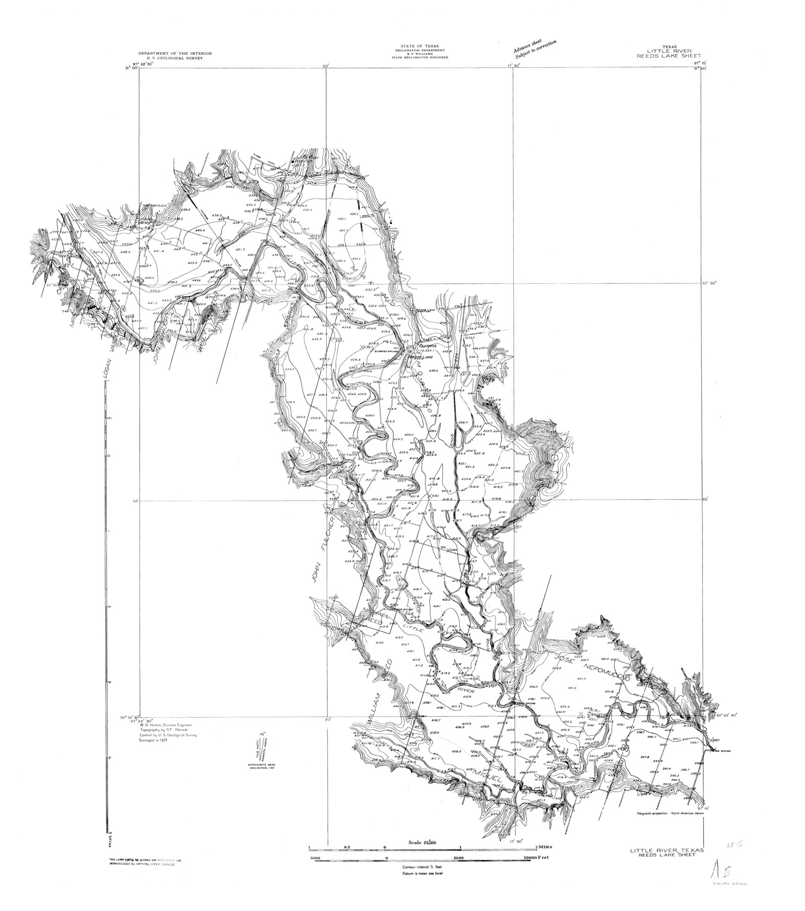
Little River, Reeds Lake Sheet
-
Map/Doc
65066
-
Collection
General Map Collection
-
Object Dates
1927 (Creation Date)
-
People and Organizations
Texas State Reclamation Department (Publisher)
S.T. Penick (Surveyor/Engineer)
-
Counties
Milam
-
Subjects
River Surveys Topographic
-
Height x Width
31.8 x 28.1 inches
80.8 x 71.4 cm
-
Comments
Little River is formed by the union of Leon River and Lampasas River. Flows southeasterly into the Brazos River.
Reeds Lake Sheet is located west of the Buckholts Sheet.
Part of: General Map Collection
Angelina County Working Sketch 11

Print $20.00
- Digital $50.00
Angelina County Working Sketch 11
1934
Size 40.9 x 31.8 inches
Map/Doc 67092
Flight Mission No. DQO-8K, Frame 12, Galveston County

Print $20.00
- Digital $50.00
Flight Mission No. DQO-8K, Frame 12, Galveston County
1952
Size 18.7 x 22.4 inches
Map/Doc 85135
Val Verde County Working Sketch 107

Print $20.00
- Digital $50.00
Val Verde County Working Sketch 107
Size 32.8 x 43.5 inches
Map/Doc 72242
Flight Mission No. DQO-3K, Frame 35, Galveston County

Print $20.00
- Digital $50.00
Flight Mission No. DQO-3K, Frame 35, Galveston County
1952
Size 18.8 x 22.5 inches
Map/Doc 85076
Trinity County Working Sketch 15

Print $20.00
- Digital $50.00
Trinity County Working Sketch 15
1974
Size 30.5 x 32.5 inches
Map/Doc 69464
Liberty County Sketch File 56

Print $20.00
- Digital $50.00
Liberty County Sketch File 56
Size 11.9 x 18.7 inches
Map/Doc 11996
Sketch of the line of march of the 2nd US Dragoons commanded by Col D. E. Tuiggs from Fort Jesup, La to Corpus Christi, Texas between the 25th of July and the 27th Aug, 1845

Print $20.00
- Digital $50.00
Sketch of the line of march of the 2nd US Dragoons commanded by Col D. E. Tuiggs from Fort Jesup, La to Corpus Christi, Texas between the 25th of July and the 27th Aug, 1845
1845
Size 25.4 x 18.3 inches
Map/Doc 72724
Cooke County Boundary File 2

Print $19.00
- Digital $50.00
Cooke County Boundary File 2
Size 12.1 x 7.6 inches
Map/Doc 51840
Brazoria County Sketch File 22

Print $4.00
- Digital $50.00
Brazoria County Sketch File 22
Size 9.6 x 8.4 inches
Map/Doc 15018
Titus County Boundary File 3

Print $6.00
- Digital $50.00
Titus County Boundary File 3
Size 7.6 x 6.9 inches
Map/Doc 59300
Comal County Sketch File 7

Print $4.00
- Digital $50.00
Comal County Sketch File 7
Size 13.5 x 8.3 inches
Map/Doc 19011
Flight Mission No. BRA-16M, Frame 112, Jefferson County

Print $20.00
- Digital $50.00
Flight Mission No. BRA-16M, Frame 112, Jefferson County
1953
Size 18.6 x 22.2 inches
Map/Doc 85722
You may also like
Hays County State Real Property Sketch 2

Print $20.00
- Digital $50.00
Hays County State Real Property Sketch 2
2006
Size 24.3 x 34.4 inches
Map/Doc 88619
McMullen County Working Sketch 25

Print $20.00
- Digital $50.00
McMullen County Working Sketch 25
1952
Size 37.5 x 43.5 inches
Map/Doc 70726
Copy of Surveyor's Field Book, Morris Browning - In Blocks 7, 5 & 4, I&GNRRCo., Hutchinson and Carson Counties, Texas

Print $2.00
- Digital $50.00
Copy of Surveyor's Field Book, Morris Browning - In Blocks 7, 5 & 4, I&GNRRCo., Hutchinson and Carson Counties, Texas
1888
Size 7.0 x 8.8 inches
Map/Doc 62259
Northeast Part Pecos County

Print $20.00
- Digital $50.00
Northeast Part Pecos County
1975
Size 35.5 x 42.3 inches
Map/Doc 77394
Dickens County, Texas

Print $20.00
- Digital $50.00
Dickens County, Texas
1883
Size 22.4 x 18.6 inches
Map/Doc 722
Winkler County Rolled Sketch 7

Print $20.00
- Digital $50.00
Winkler County Rolled Sketch 7
1929
Size 27.6 x 32.5 inches
Map/Doc 8273
Collingsworth County Sketch File 11

Print $32.00
- Digital $50.00
Collingsworth County Sketch File 11
1991
Size 11.2 x 8.6 inches
Map/Doc 18893
Matagorda Bay Including Lavaca and Tres Palacios Bays

Print $20.00
- Digital $50.00
Matagorda Bay Including Lavaca and Tres Palacios Bays
1992
Size 37.0 x 47.8 inches
Map/Doc 73366
Colorado River, Carancahua Sheet

Print $20.00
- Digital $50.00
Colorado River, Carancahua Sheet
1940
Size 30.7 x 38.0 inches
Map/Doc 65320
Zavala County Sketch File 11

Print $4.00
- Digital $50.00
Zavala County Sketch File 11
1885
Size 14.4 x 8.8 inches
Map/Doc 41270
Pecos County Sketch File 82

Print $46.00
- Digital $50.00
Pecos County Sketch File 82
1944
Size 14.2 x 8.8 inches
Map/Doc 33927
[Rio Grande & Eagle Pass - Stockdale to Cuero]
![64048, [Rio Grande & Eagle Pass - Stockdale to Cuero], General Map Collection](https://historictexasmaps.com/wmedia_w700/maps/64048.tif.jpg)
Print $40.00
- Digital $50.00
[Rio Grande & Eagle Pass - Stockdale to Cuero]
Size 19.9 x 122.5 inches
Map/Doc 64048