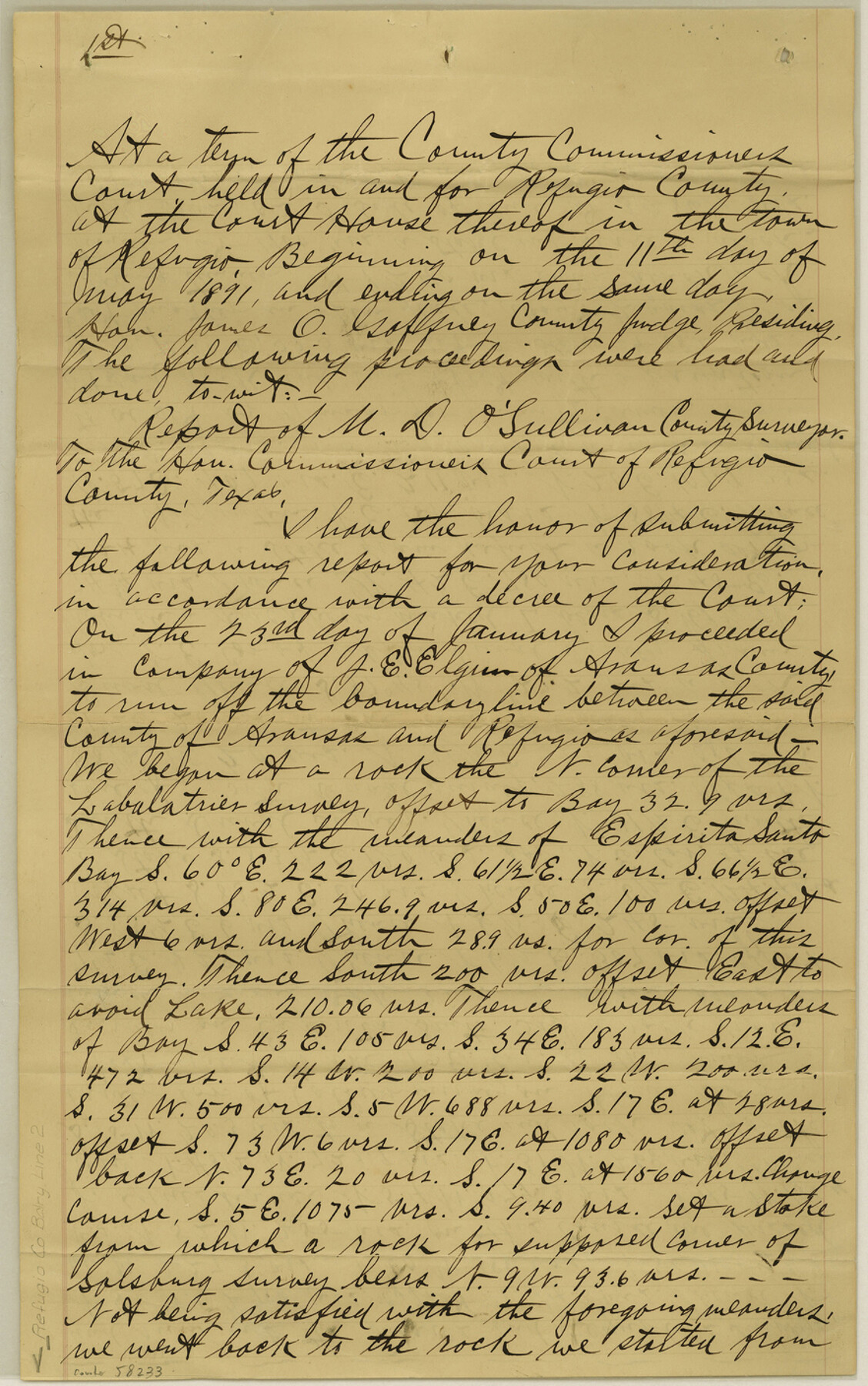
Refugio County Boundary File 2
Line of Aransas and Refugio Counties Established Jan. 1891
-
Map/Doc
58233
-
Collection
General Map Collection
-
Counties
Refugio
-
Subjects
County Boundaries
-
Height x Width
14.1 x 8.8 inches
35.8 x 22.4 cm
Part of: General Map Collection
Montague County Rolled Sketch 1

Print $20.00
- Digital $50.00
Montague County Rolled Sketch 1
Size 31.7 x 26.9 inches
Map/Doc 6786
Flight Mission No. CLL-1N, Frame 32, Willacy County

Print $20.00
- Digital $50.00
Flight Mission No. CLL-1N, Frame 32, Willacy County
1954
Size 17.5 x 19.4 inches
Map/Doc 87013
[Gulf Colorado & Santa Fe from 2178+36.0 to 3901+06.2]
![64695, [Gulf Colorado & Santa Fe from 2178+36.0 to 3901+06.2], General Map Collection](https://historictexasmaps.com/wmedia_w700/maps/64695-1.tif.jpg)
Print $40.00
- Digital $50.00
[Gulf Colorado & Santa Fe from 2178+36.0 to 3901+06.2]
Size 33.6 x 120.7 inches
Map/Doc 64695
Stephens County Working Sketch 11

Print $20.00
- Digital $50.00
Stephens County Working Sketch 11
1921
Size 21.0 x 16.5 inches
Map/Doc 63954
Zapata County Rolled Sketch 12B

Print $40.00
- Digital $50.00
Zapata County Rolled Sketch 12B
1917
Size 55.7 x 40.0 inches
Map/Doc 10166
The United States of America

Print $20.00
- Digital $50.00
The United States of America
1866
Size 21.3 x 18.3 inches
Map/Doc 72646
Brown County Working Sketch 19

Print $20.00
- Digital $50.00
Brown County Working Sketch 19
1998
Size 37.1 x 34.8 inches
Map/Doc 67784
University Land Field Notes for Blocks 34 through 37 in Terrell County

University Land Field Notes for Blocks 34 through 37 in Terrell County
Map/Doc 81720

Hunt County Boundary File 49

Print $44.00
- Digital $50.00
Hunt County Boundary File 49
Size 9.1 x 5.2 inches
Map/Doc 55279
Northwest Part Crockett County

Print $40.00
- Digital $50.00
Northwest Part Crockett County
1983
Size 38.1 x 48.8 inches
Map/Doc 73121
Val Verde County Working Sketch 30

Print $20.00
- Digital $50.00
Val Verde County Working Sketch 30
1938
Size 37.9 x 28.5 inches
Map/Doc 72165
You may also like
Political Essay on the Kingdom of New Spain Vol. 2, Third Edition

Political Essay on the Kingdom of New Spain Vol. 2, Third Edition
1822
Map/Doc 97387
Starr County Sketch File 40

Print $4.00
- Digital $50.00
Starr County Sketch File 40
1940
Size 14.2 x 8.8 inches
Map/Doc 36989
Flight Mission No. DCL-7C, Frame 141, Kenedy County

Print $20.00
- Digital $50.00
Flight Mission No. DCL-7C, Frame 141, Kenedy County
1943
Size 18.5 x 22.4 inches
Map/Doc 86098
Montague County Working Sketch 21

Print $20.00
- Digital $50.00
Montague County Working Sketch 21
1952
Size 33.1 x 39.5 inches
Map/Doc 71087
Liberty County Sketch File 6

Print $6.00
- Digital $50.00
Liberty County Sketch File 6
1856
Size 12.1 x 7.7 inches
Map/Doc 29893
Map of the State of Texas from the Latest Authorities

Print $20.00
- Digital $50.00
Map of the State of Texas from the Latest Authorities
1854
Size 13.1 x 16.1 inches
Map/Doc 93901
Nueces County NRC Article 33.136 Location Key Sheet

Print $20.00
- Digital $50.00
Nueces County NRC Article 33.136 Location Key Sheet
1975
Size 27.3 x 23.0 inches
Map/Doc 88587
Orange County Sketch File 31

Print $20.00
- Digital $50.00
Orange County Sketch File 31
1926
Size 17.9 x 20.0 inches
Map/Doc 12125
Kenedy County Working Sketch 2a

Print $20.00
- Digital $50.00
Kenedy County Working Sketch 2a
1907
Size 22.2 x 20.9 inches
Map/Doc 70003
Campbell's Addition to El Paso, Texas

Print $20.00
- Digital $50.00
Campbell's Addition to El Paso, Texas
1885
Size 43.5 x 43.1 inches
Map/Doc 8854
Jefferson County Working Sketch 11

Print $20.00
- Digital $50.00
Jefferson County Working Sketch 11
1943
Size 46.6 x 43.0 inches
Map/Doc 66554
Jim Wells County Working Sketch 5

Print $20.00
- Digital $50.00
Jim Wells County Working Sketch 5
1942
Size 44.3 x 42.9 inches
Map/Doc 66603