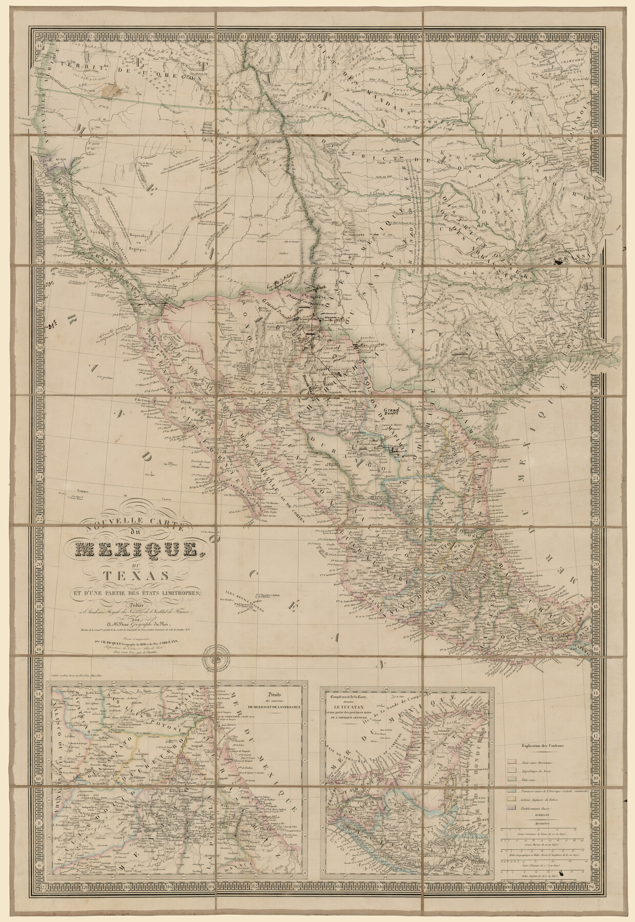
Nouvelle carte du Mexique, du Texas et d'une partie des États Limitrophes
[Inset 1: Détails des environs de Mexico et de la Vera-Cruz / Inset 2: Complément de la Carte donnant le Yucatan et une partie des provinces unies de l'Amérique Centrale]
-
Map/Doc
93764
-
Collection
Rees-Jones Digital Map Collection
-
Object Dates
1834 (Creation Date)
1845 (Revision Date)
-
People and Organizations
Ch. Picquet (Author)
Adrien Hubert Brué (Cartographer)
-
Subjects
Mexican Texas Mexico Republic of Texas
-
Height x Width
39.5 x 27.2 inches
100.3 x 69.1 cm
-
Comments
Courtesy of the Rees-Jones Collection, Dallas, TX See 93765 for reverse.
Part of: Rees-Jones Digital Map Collection
Morley's Map of New Mexico compiled from the latest government surveys and other reliable sources

Print $20.00
- Digital $50.00
Morley's Map of New Mexico compiled from the latest government surveys and other reliable sources
1873
Size 26.2 x 28.0 inches
Map/Doc 94052
Guide map of the Great Texas Cattle Trail from Red River crossing to the Old Reliable Kansas Pacific Railway

Print $20.00
- Digital $50.00
Guide map of the Great Texas Cattle Trail from Red River crossing to the Old Reliable Kansas Pacific Railway
1873
Size 23.4 x 17.6 inches
Map/Doc 93938
Kansas and Nebraska

Print $20.00
- Digital $50.00
Kansas and Nebraska
Size 30.8 x 19.4 inches
Map/Doc 93994
Map of Texas With Parts of the Adjoining States

Print $20.00
- Digital $50.00
Map of Texas With Parts of the Adjoining States
1836
Size 30.9 x 24.8 inches
Map/Doc 93932
Map of the River Sabine from its mouth on the Gulf of Mexico in the sea to Logan's Ferry

Print $20.00
- Digital $50.00
Map of the River Sabine from its mouth on the Gulf of Mexico in the sea to Logan's Ferry
1842
Size 37.5 x 9.4 inches
Map/Doc 93767
Geological map of Texas showing approximate locations and drilling wells. Also names of companies drilling

Print $20.00
- Digital $50.00
Geological map of Texas showing approximate locations and drilling wells. Also names of companies drilling
1920
Size 26.9 x 26.6 inches
Map/Doc 93937
A New Map of Texas with the Contiguous American & Mexican States

Print $20.00
- Digital $50.00
A New Map of Texas with the Contiguous American & Mexican States
1839
Size 13.5 x 16.1 inches
Map/Doc 93941
Map of Mexico, including Yucatan & Upper California, exhibiting the chief cities and towns, the principal travelling routes &c.

Print $20.00
- Digital $50.00
Map of Mexico, including Yucatan & Upper California, exhibiting the chief cities and towns, the principal travelling routes &c.
1847
Size 33.5 x 24.7 inches
Map/Doc 93936
Part of the boundary between the United States and Texas; north of Sabine River from the 36th to the 72nd mile mound

Print $3.00
- Digital $50.00
Part of the boundary between the United States and Texas; north of Sabine River from the 36th to the 72nd mile mound
1842
Size 12.0 x 8.8 inches
Map/Doc 93770
Colton's Map of United States, the Canadas & c. showing the Railraods, Canals & Stage Roads with distances from place to place

Print $20.00
- Digital $50.00
Colton's Map of United States, the Canadas & c. showing the Railraods, Canals & Stage Roads with distances from place to place
Size 28.8 x 33.0 inches
Map/Doc 93983
Chart of the Antarctic Continent shewing the icy barrier attached to it discovered by the U.S. Ex. Ex.

Print $20.00
- Digital $50.00
Chart of the Antarctic Continent shewing the icy barrier attached to it discovered by the U.S. Ex. Ex.
1840
Size 26.5 x 37.2 inches
Map/Doc 94058
A. R. Roessler's Latest Map of the State of Texas Exhibiting Mineral and Agricultural Districts, Post Offices and Mailroutes, Railroads projected and finished, Timber, Prairie, Swamp Lands, etc. etc. etc.

Print $20.00
- Digital $50.00
A. R. Roessler's Latest Map of the State of Texas Exhibiting Mineral and Agricultural Districts, Post Offices and Mailroutes, Railroads projected and finished, Timber, Prairie, Swamp Lands, etc. etc. etc.
1874
Size 40.8 x 47.4 inches
Map/Doc 93934
You may also like
Presidio County Sketch File 36

Print $10.00
- Digital $50.00
Presidio County Sketch File 36
1908
Size 10.4 x 8.2 inches
Map/Doc 34486
Map of Giddings

Print $20.00
- Digital $50.00
Map of Giddings
1940
Size 16.5 x 21.2 inches
Map/Doc 2210
[Sketch for Mineral Application 19560 - 19588 - San Bernard River]
![65660, [Sketch for Mineral Application 19560 - 19588 - San Bernard River], General Map Collection](https://historictexasmaps.com/wmedia_w700/maps/65660.tif.jpg)
Print $40.00
- Digital $50.00
[Sketch for Mineral Application 19560 - 19588 - San Bernard River]
Size 98.0 x 33.0 inches
Map/Doc 65660
Notes for map of Montgomery County

Print $20.00
- Digital $50.00
Notes for map of Montgomery County
1844
Size 17.6 x 21.9 inches
Map/Doc 78370
Webb County Sketch File 45

Print $20.00
- Digital $50.00
Webb County Sketch File 45
1883
Size 17.5 x 22.5 inches
Map/Doc 12642
Eastland County Working Sketch 9

Print $20.00
- Digital $50.00
Eastland County Working Sketch 9
1919
Size 33.0 x 30.6 inches
Map/Doc 68790
Anderson County Boundary File 5

Print $10.00
- Digital $50.00
Anderson County Boundary File 5
Size 8.1 x 7.2 inches
Map/Doc 49742
Presidio County Working Sketch 87

Print $20.00
- Digital $50.00
Presidio County Working Sketch 87
1971
Size 37.6 x 37.9 inches
Map/Doc 71764
Wichita County Sketch File A

Print $4.00
- Digital $50.00
Wichita County Sketch File A
1861
Size 7.8 x 10.3 inches
Map/Doc 40036
Haskell County Working Sketch 5

Print $20.00
- Digital $50.00
Haskell County Working Sketch 5
1945
Size 22.2 x 37.2 inches
Map/Doc 66063
Medina County Working Sketch 30

Print $20.00
- Digital $50.00
Medina County Working Sketch 30
1992
Size 19.2 x 15.4 inches
Map/Doc 70945
Brooks County Rolled Sketch 20

Print $20.00
- Digital $50.00
Brooks County Rolled Sketch 20
1943
Size 27.0 x 26.4 inches
Map/Doc 5342