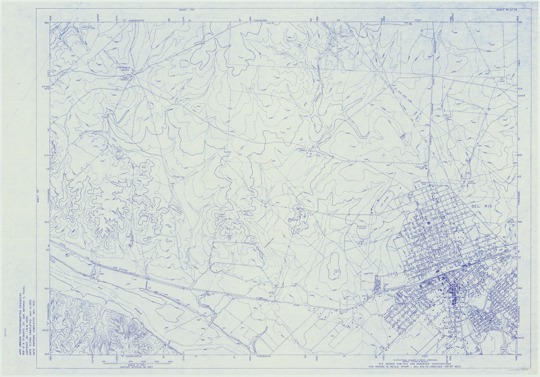
Amistad International Reservoir on Rio Grande 99
Rio Grande Dam Site and Reservoir Investigations
-
Map/Doc
75530
-
Collection
General Map Collection
-
Object Dates
1950 (Creation Date)
-
People and Organizations
International Boundary and Water Commission (Publisher)
Jack Ammann Photogrammetric Engineers (Surveyor/Engineer)
-
Counties
Val Verde
-
Subjects
Texas Boundaries Topographic
-
Height x Width
28.4 x 40.7 inches
72.1 x 103.4 cm
-
Medium
blueline
-
Comments
Rio Grande and Devil's River - Del Rio to Longitude 102 degrees 30 minutes West.
Part of: General Map Collection
Stonewall County

Print $20.00
- Digital $50.00
Stonewall County
1933
Size 47.6 x 39.5 inches
Map/Doc 73295
Hardeman County Sketch File 7

Print $10.00
- Digital $50.00
Hardeman County Sketch File 7
Size 8.9 x 14.1 inches
Map/Doc 24997
Sectional Map No. 2 of the lands and the line of the Texas & Pacific Ry. Co. in Howard, Martin, Andrews, Midland and Tom Green Counties

Print $20.00
- Digital $50.00
Sectional Map No. 2 of the lands and the line of the Texas & Pacific Ry. Co. in Howard, Martin, Andrews, Midland and Tom Green Counties
1885
Size 19.1 x 23.2 inches
Map/Doc 4860
Brewster County Sketch File N-31

Print $2.00
- Digital $50.00
Brewster County Sketch File N-31
1969
Size 12.9 x 9.0 inches
Map/Doc 15711
Foard County Sketch File 33

Print $26.00
- Digital $50.00
Foard County Sketch File 33
1958
Size 11.4 x 8.9 inches
Map/Doc 22866
Flight Mission No. CUG-1P, Frame 45, Kleberg County

Print $20.00
- Digital $50.00
Flight Mission No. CUG-1P, Frame 45, Kleberg County
1956
Size 18.5 x 22.2 inches
Map/Doc 86123
Flight Mission No. BRE-2P, Frame 41, Nueces County

Print $20.00
- Digital $50.00
Flight Mission No. BRE-2P, Frame 41, Nueces County
1956
Size 18.5 x 22.4 inches
Map/Doc 86743
Liberty County Sketch File 51

Print $4.00
- Digital $50.00
Liberty County Sketch File 51
Size 7.9 x 13.8 inches
Map/Doc 30017
East Half - Brown County

Print $40.00
- Digital $50.00
East Half - Brown County
1982
Size 141.3 x 36.8 inches
Map/Doc 97385
Duval County Sketch File 35

Print $24.00
- Digital $50.00
Duval County Sketch File 35
Size 14.4 x 8.8 inches
Map/Doc 21359
Jeff Davis County Working Sketch 44

Print $20.00
- Digital $50.00
Jeff Davis County Working Sketch 44
1984
Size 28.8 x 37.4 inches
Map/Doc 66539
Travis County Appraisal District Plat Map 3_0404

Print $20.00
- Digital $50.00
Travis County Appraisal District Plat Map 3_0404
Size 21.5 x 26.4 inches
Map/Doc 94226
You may also like
Waller County Working Sketch Graphic Index

Print $20.00
- Digital $50.00
Waller County Working Sketch Graphic Index
1945
Size 46.7 x 27.2 inches
Map/Doc 76730
Donley County Working Sketch 9

Print $20.00
- Digital $50.00
Donley County Working Sketch 9
1982
Size 24.7 x 42.2 inches
Map/Doc 68742
[Right of Way and Track Map, the Missouri, Kansas and Texas Ry. of Texas - Henrietta Division]
![64757, [Right of Way and Track Map, the Missouri, Kansas and Texas Ry. of Texas - Henrietta Division], General Map Collection](https://historictexasmaps.com/wmedia_w700/maps/64757.tif.jpg)
Print $20.00
- Digital $50.00
[Right of Way and Track Map, the Missouri, Kansas and Texas Ry. of Texas - Henrietta Division]
1918
Size 11.8 x 26.9 inches
Map/Doc 64757
Travis County Sketch File 77

Print $26.00
- Digital $50.00
Travis County Sketch File 77
2004
Size 11.0 x 8.5 inches
Map/Doc 83254
Limestone County Sketch File 16

Print $4.00
- Digital $50.00
Limestone County Sketch File 16
Size 12.8 x 8.3 inches
Map/Doc 30185
King County Working Sketch 12

Print $20.00
- Digital $50.00
King County Working Sketch 12
1975
Size 42.6 x 28.4 inches
Map/Doc 70176
General Highway Map, Jasper County, Texas

Print $20.00
General Highway Map, Jasper County, Texas
1961
Size 18.2 x 24.8 inches
Map/Doc 79534
Ward County Working Sketch 45

Print $40.00
- Digital $50.00
Ward County Working Sketch 45
1973
Size 56.8 x 28.3 inches
Map/Doc 72351
Jim Hogg County Sketch File 6a

Print $6.00
- Digital $50.00
Jim Hogg County Sketch File 6a
1939
Size 11.1 x 8.7 inches
Map/Doc 28408
San Patricio County Rolled Sketch 46D

Print $20.00
- Digital $50.00
San Patricio County Rolled Sketch 46D
1983
Size 14.8 x 36.0 inches
Map/Doc 8375
Bandera County Working Sketch 25

Print $20.00
- Digital $50.00
Bandera County Working Sketch 25
1950
Size 30.4 x 38.5 inches
Map/Doc 67621
Presidio County Sketch File 76

Print $20.00
- Digital $50.00
Presidio County Sketch File 76
Size 22.0 x 18.3 inches
Map/Doc 11720