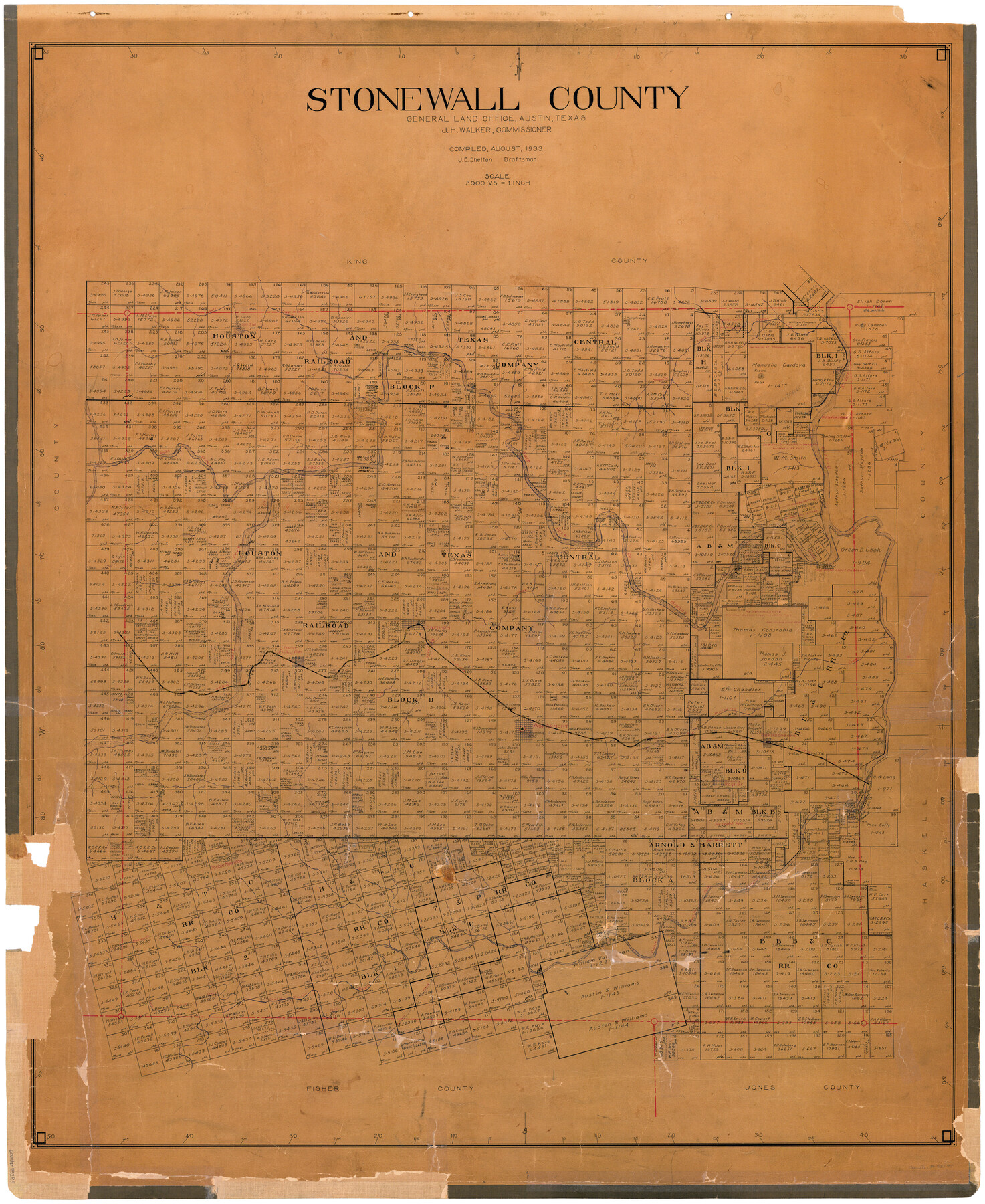
Stonewall County
-
Map/Doc
73295
-
Collection
General Map Collection
-
Object Dates
1933 (Creation Date)
-
People and Organizations
Texas General Land Office (Publisher)
John E. Shelton Jr. (Draftsman)
J.H. Walker (GLO Commissioner)
-
Counties
Stonewall
-
Subjects
County
-
Height x Width
47.6 x 39.5 inches
120.9 x 100.3 cm
-
Comments
Hand lettered.
Note on reverse side: "Hung September 30, 1933 John E. Shelton." -
Features
S&NW
South Nicholson's Creek
Gypsum Creek
Nicholson's Creek
Double Mountain Fork of Brazos River
Double Mountain
Rayner
Old Glory
Brandenburg
Mulberry Creek
Aspermont
Salt Creek
Peacock
Alluvia
Big Stinking Creek
Swenson
Salt Fork of Brazos River
Brazos River
Big South Croton Creek
Kiowa Peak
Mesquite Creek
Croton Creek
Part of: General Map Collection
Presidio County Working Sketch 21

Print $20.00
- Digital $50.00
Presidio County Working Sketch 21
1945
Size 25.4 x 35.9 inches
Map/Doc 71697
Galveston County Sketch File 73I

Print $20.00
- Digital $50.00
Galveston County Sketch File 73I
Size 31.5 x 26.0 inches
Map/Doc 11543
Map of Wilson County

Print $20.00
- Digital $50.00
Map of Wilson County
1879
Size 23.0 x 24.4 inches
Map/Doc 4157
Sketch of a portion of the Texas Coast showing the relative positions of different harbours with the interior Military Posts, and the roads communicating with them, also two new routes from Black Point and Lamar to San Antonio

Print $20.00
- Digital $50.00
Sketch of a portion of the Texas Coast showing the relative positions of different harbours with the interior Military Posts, and the roads communicating with them, also two new routes from Black Point and Lamar to San Antonio
1855
Size 27.5 x 18.2 inches
Map/Doc 72708
Located Line of the Panhandle & Gulf Ry. through State Lands, Public School and University, Right of Way 200 feet wide, in Brewster County, Texas.

Print $40.00
- Digital $50.00
Located Line of the Panhandle & Gulf Ry. through State Lands, Public School and University, Right of Way 200 feet wide, in Brewster County, Texas.
1904
Size 14.8 x 99.1 inches
Map/Doc 64059
Tarrant County

Print $20.00
- Digital $50.00
Tarrant County
1873
Size 18.6 x 17.4 inches
Map/Doc 4631
Map of The Surveyed Part of Peters Colony Texas

Print $40.00
- Digital $50.00
Map of The Surveyed Part of Peters Colony Texas
1854
Size 53.5 x 65.9 inches
Map/Doc 1967
Menard County Working Sketch 15

Print $20.00
- Digital $50.00
Menard County Working Sketch 15
1943
Size 18.6 x 20.6 inches
Map/Doc 70962
[Surveyor's certificate by James Howlet, District Surveyor]
![318, [Surveyor's certificate by James Howlet, District Surveyor], General Map Collection](https://historictexasmaps.com/wmedia_w700/maps/318.tif.jpg)
Print $2.00
- Digital $50.00
[Surveyor's certificate by James Howlet, District Surveyor]
Size 6.1 x 8.0 inches
Map/Doc 318
Crockett County Rolled Sketch CRV

Print $40.00
- Digital $50.00
Crockett County Rolled Sketch CRV
1925
Size 35.8 x 52.3 inches
Map/Doc 8693
Stonewall County Working Sketch Graphic Index - sheet A

Print $20.00
- Digital $50.00
Stonewall County Working Sketch Graphic Index - sheet A
1933
Size 43.3 x 36.2 inches
Map/Doc 76704
Roberts County Working Sketch 15

Print $20.00
- Digital $50.00
Roberts County Working Sketch 15
1975
Size 40.5 x 38.7 inches
Map/Doc 63541
You may also like
Crockett County Working Sketch 64

Print $20.00
- Digital $50.00
Crockett County Working Sketch 64
1957
Size 19.0 x 25.4 inches
Map/Doc 68397
Coast Chart No. 210 Aransas Pass and Corpus Christi Bay with the coast to latitude 27° 12' Texas

Print $20.00
- Digital $50.00
Coast Chart No. 210 Aransas Pass and Corpus Christi Bay with the coast to latitude 27° 12' Texas
1887
Size 27.2 x 18.2 inches
Map/Doc 72801
[Blocks M17, M18, M23, XO2, L, Z, and Block 47, Sections 18-25]
![91241, [Blocks M17, M18, M23, XO2, L, Z, and Block 47, Sections 18-25], Twichell Survey Records](https://historictexasmaps.com/wmedia_w700/maps/91241-1.tif.jpg)
Print $20.00
- Digital $50.00
[Blocks M17, M18, M23, XO2, L, Z, and Block 47, Sections 18-25]
Size 32.3 x 26.2 inches
Map/Doc 91241
Aransas County Working Sketch 21

Print $20.00
- Digital $50.00
Aransas County Working Sketch 21
1980
Size 17.0 x 36.2 inches
Map/Doc 67188
Crockett County Rolled Sketch 88N

Print $89.00
- Digital $50.00
Crockett County Rolled Sketch 88N
1973
Size 10.6 x 15.5 inches
Map/Doc 44132
Galveston Harbor and Channel, Texas - Rehabilitation of Galveston Groins - Location Plan of Rehabilitation

Print $4.00
- Digital $50.00
Galveston Harbor and Channel, Texas - Rehabilitation of Galveston Groins - Location Plan of Rehabilitation
1968
Size 19.7 x 21.5 inches
Map/Doc 73627
Flight Mission No. DCL-7C, Frame 16, Kenedy County

Print $20.00
- Digital $50.00
Flight Mission No. DCL-7C, Frame 16, Kenedy County
1943
Size 15.2 x 15.4 inches
Map/Doc 86008
Live Oak County Sketch File 7

Print $4.00
- Digital $50.00
Live Oak County Sketch File 7
1875
Size 8.8 x 8.3 inches
Map/Doc 30259
Pecos County Rolled Sketch 89

Print $40.00
- Digital $50.00
Pecos County Rolled Sketch 89
1934
Size 56.2 x 41.4 inches
Map/Doc 10719
Childress County Sketch File 16

Print $8.00
- Digital $50.00
Childress County Sketch File 16
1888
Size 13.9 x 8.5 inches
Map/Doc 18282
[Hutchinson County Resurveys South of the Canadian River]
![91166, [Hutchinson County Resurveys South of the Canadian River], Twichell Survey Records](https://historictexasmaps.com/wmedia_w700/maps/91166-1.tif.jpg)
Print $20.00
- Digital $50.00
[Hutchinson County Resurveys South of the Canadian River]
1920
Size 33.3 x 21.1 inches
Map/Doc 91166
Cooke County Sketch File 41

Print $36.00
- Digital $50.00
Cooke County Sketch File 41
1928
Size 11.3 x 8.9 inches
Map/Doc 19308