Kaufman County State Real Property Sketch 2
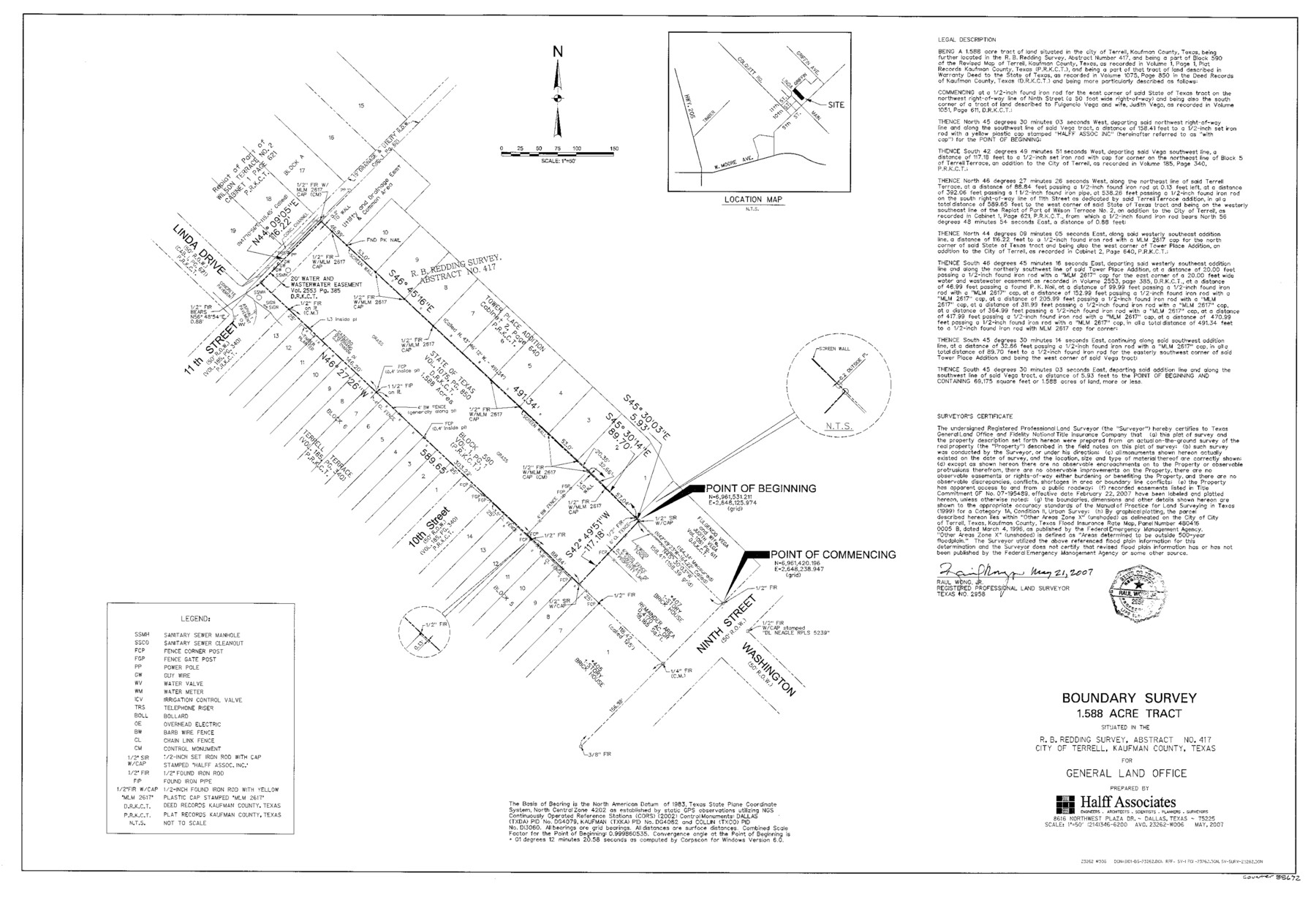
A Boundary Survey of a 1.588 Acre Tract Situated in the R. B. Redding Survey, A - 417, City of Terrell
-
Map/Doc
88672
-
Collection
General Map Collection
-
Object Dates
2007/5/21 (Creation Date)
-
People and Organizations
Halff Associates (Publisher)
Halff Associates (Printer)
Raul Wong Jr. (Surveyor/Engineer)
-
Counties
Kaufman
-
Subjects
State Real Property
-
Height x Width
24.2 x 35.4 inches
61.5 x 89.9 cm
-
Comments
Surveys located about 11 miles North five degrees East of Kaufman, Texas.
Part of: General Map Collection
Map of Tom Green Co.

Print $40.00
- Digital $50.00
Map of Tom Green Co.
1880
Size 42.5 x 74.3 inches
Map/Doc 82062
Crockett County Sketch File 10 and 11

Print $8.00
- Digital $50.00
Crockett County Sketch File 10 and 11
Size 12.6 x 7.3 inches
Map/Doc 19661
Nueces County NRC Article 33.136 Sketch 19

Print $38.00
- Digital $50.00
Nueces County NRC Article 33.136 Sketch 19
2015
Size 35.0 x 22.0 inches
Map/Doc 94767
Bee County Working Sketch 30

Print $20.00
- Digital $50.00
Bee County Working Sketch 30
1950
Size 12.7 x 15.7 inches
Map/Doc 67281
Upton County Working Sketch 47

Print $20.00
- Digital $50.00
Upton County Working Sketch 47
1973
Size 24.8 x 26.7 inches
Map/Doc 69543
Flight Mission No. BRA-16M, Frame 180, Jefferson County

Print $20.00
- Digital $50.00
Flight Mission No. BRA-16M, Frame 180, Jefferson County
1953
Size 18.5 x 22.4 inches
Map/Doc 85778
Flight Mission No. DQN-6K, Frame 5, Calhoun County

Print $20.00
- Digital $50.00
Flight Mission No. DQN-6K, Frame 5, Calhoun County
1953
Size 18.6 x 22.1 inches
Map/Doc 84427
El Paso County Rolled Sketch 53

Print $105.00
- Digital $50.00
El Paso County Rolled Sketch 53
1930
Size 10.1 x 15.3 inches
Map/Doc 44486
Leon County Working Sketch 27

Print $20.00
- Digital $50.00
Leon County Working Sketch 27
1970
Size 22.4 x 24.4 inches
Map/Doc 70426
Brewster County Sketch File FN-34

Print $40.00
- Digital $50.00
Brewster County Sketch File FN-34
1943
Size 23.1 x 27.1 inches
Map/Doc 10984
Comanche County Sketch File 2

Print $40.00
- Digital $50.00
Comanche County Sketch File 2
1849
Size 16.0 x 12.9 inches
Map/Doc 19053
San Jacinto County Working Sketch 1

Print $20.00
- Digital $50.00
San Jacinto County Working Sketch 1
Size 30.0 x 29.6 inches
Map/Doc 63714
You may also like
Brewster County Rolled Sketch 122

Print $20.00
- Digital $50.00
Brewster County Rolled Sketch 122
1974
Size 31.9 x 24.6 inches
Map/Doc 5298
Hall County Rolled Sketch 8

Print $20.00
- Digital $50.00
Hall County Rolled Sketch 8
1942
Size 24.7 x 41.6 inches
Map/Doc 6052
Flight Mission No. CUG-2P, Frame 66, Kleberg County

Print $20.00
- Digital $50.00
Flight Mission No. CUG-2P, Frame 66, Kleberg County
1956
Size 18.5 x 22.2 inches
Map/Doc 86203
Flight Mission No. DAG-26K, Frame 63, Matagorda County

Print $20.00
- Digital $50.00
Flight Mission No. DAG-26K, Frame 63, Matagorda County
1953
Size 18.5 x 22.2 inches
Map/Doc 86583
Uvalde County Rolled Sketch 14

Print $20.00
- Digital $50.00
Uvalde County Rolled Sketch 14
1977
Size 22.0 x 25.9 inches
Map/Doc 8098
A Map of the British Empire in North America

Print $20.00
- Digital $50.00
A Map of the British Empire in North America
1774
Size 22.1 x 15.1 inches
Map/Doc 93733
Tom Green County Boundary File 1

Print $48.00
- Digital $50.00
Tom Green County Boundary File 1
Size 8.8 x 3.8 inches
Map/Doc 59329
Map of the Texas & Pacific Ry. Reserve West of the Pecos River

Print $20.00
- Digital $50.00
Map of the Texas & Pacific Ry. Reserve West of the Pecos River
1879
Size 41.2 x 29.9 inches
Map/Doc 65334
Galveston County NRC Article 33.136 Sketch 67

Print $28.00
- Digital $50.00
Galveston County NRC Article 33.136 Sketch 67
2011
Size 17.0 x 24.0 inches
Map/Doc 93391
Eastland County Working Sketch 63

Print $20.00
- Digital $50.00
Eastland County Working Sketch 63
1997
Size 36.7 x 37.6 inches
Map/Doc 68844
Morris County Sketch File 5

Print $20.00
- Digital $50.00
Morris County Sketch File 5
Size 21.4 x 11.6 inches
Map/Doc 42132
[Sketch showing I. & G. N. Block 8]
![91703, [Sketch showing I. & G. N. Block 8], Twichell Survey Records](https://historictexasmaps.com/wmedia_w700/maps/91703-1.tif.jpg)
Print $2.00
- Digital $50.00
[Sketch showing I. & G. N. Block 8]
1919
Size 5.0 x 8.7 inches
Map/Doc 91703