Brewster County Rolled Sketch 122
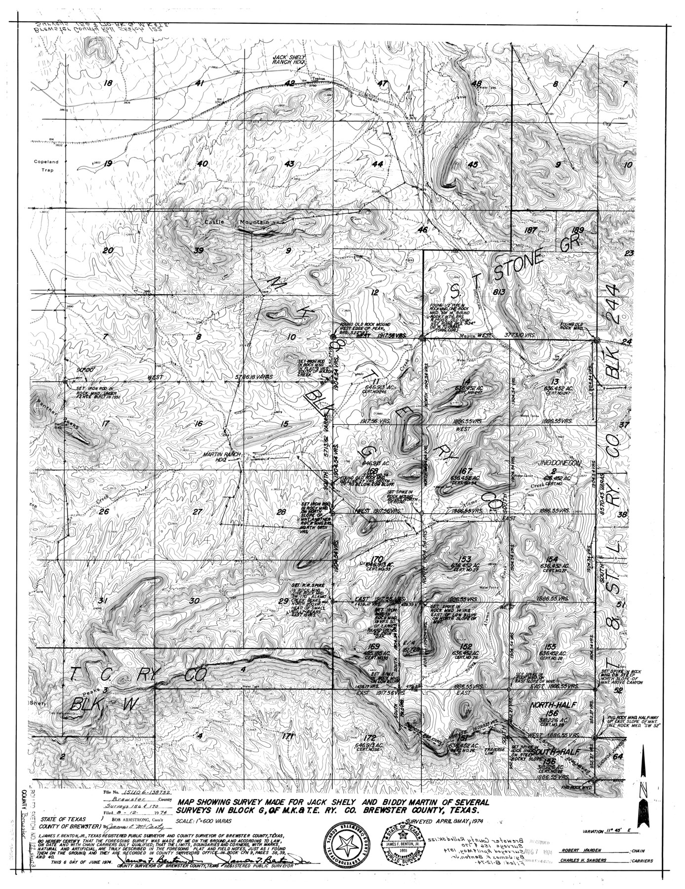
Map showing survey made for Jack Shely and Biddy Martin of several surveys in Block G, of M. K. & T. E. Ry. Co. Brewster County, Texas (Sheet 3 of 3)
-
Map/Doc
5298
-
Collection
General Map Collection
-
Object Dates
1974/6/6 (Creation Date)
1974/8/12 (File Date)
-
People and Organizations
James F. Benton, Jr. (Surveyor/Engineer)
Robert Harden (Chainman/Field Personnel)
Charles H. Sanders (Chainman/Field Personnel)
-
Counties
Brewster
-
Subjects
Surveying Rolled Sketch
-
Height x Width
31.9 x 24.6 inches
81.0 x 62.5 cm
-
Scale
1" = 600 varas
-
Comments
For other sheets see 5296 and 5297.
Related maps
Brewster County Rolled Sketch 122

Print $20.00
- Digital $50.00
Brewster County Rolled Sketch 122
1974
Size 33.4 x 24.8 inches
Map/Doc 5296
Brewster County Rolled Sketch 122

Print $20.00
- Digital $50.00
Brewster County Rolled Sketch 122
1974
Size 32.0 x 25.5 inches
Map/Doc 5297
Part of: General Map Collection
Dallas, Ft. Worth, & Vicinity, Texas - Regional Map

Dallas, Ft. Worth, & Vicinity, Texas - Regional Map
1997
Size 25.7 x 36.7 inches
Map/Doc 97289
Val Verde County Sketch File Z4

Print $8.00
- Digital $50.00
Val Verde County Sketch File Z4
1885
Size 14.3 x 8.9 inches
Map/Doc 39134
Harrison County Sketch File 21

Print $20.00
- Digital $50.00
Harrison County Sketch File 21
1892
Size 20.2 x 25.7 inches
Map/Doc 11694
Trinity County Sketch File 10

Print $8.00
- Digital $50.00
Trinity County Sketch File 10
1858
Size 13.1 x 8.0 inches
Map/Doc 38527
[FT. W. & R. G. Ry. Right of Way Map, Winchell to Brady, McCulloch County, Texas]
![61411, [FT. W. & R. G. Ry. Right of Way Map, Winchell to Brady, McCulloch County, Texas], General Map Collection](https://historictexasmaps.com/wmedia_w700/maps/61411.tif.jpg)
Print $20.00
- Digital $50.00
[FT. W. & R. G. Ry. Right of Way Map, Winchell to Brady, McCulloch County, Texas]
1918
Size 37.0 x 26.9 inches
Map/Doc 61411
Hutchinson County Working Sketch 35

Print $20.00
- Digital $50.00
Hutchinson County Working Sketch 35
1978
Size 27.0 x 22.3 inches
Map/Doc 66395
Houston County Sketch File 25

Print $4.00
- Digital $50.00
Houston County Sketch File 25
Size 12.8 x 8.1 inches
Map/Doc 26798
Flight Mission No. CGI-3N, Frame 176, Cameron County

Print $20.00
- Digital $50.00
Flight Mission No. CGI-3N, Frame 176, Cameron County
1954
Size 18.6 x 22.4 inches
Map/Doc 84640
Tom Green County Rolled Sketch 14

Print $20.00
- Digital $50.00
Tom Green County Rolled Sketch 14
1953
Size 28.3 x 30.9 inches
Map/Doc 7999
Kent County Sketch File 9

Print $8.00
- Digital $50.00
Kent County Sketch File 9
Size 10.3 x 8.1 inches
Map/Doc 28832
Crockett County Working Sketch 6

Print $20.00
- Digital $50.00
Crockett County Working Sketch 6
Size 20.7 x 21.7 inches
Map/Doc 68339
El Paso County Working Sketch 17

Print $20.00
- Digital $50.00
El Paso County Working Sketch 17
1958
Size 28.4 x 26.3 inches
Map/Doc 69039
You may also like
Morton Independent School District, Cochran County, Texas

Print $20.00
- Digital $50.00
Morton Independent School District, Cochran County, Texas
Size 26.3 x 23.9 inches
Map/Doc 92519
Sterling County Sketch File 1

Print $40.00
- Digital $50.00
Sterling County Sketch File 1
1862
Size 18.7 x 8.4 inches
Map/Doc 37111
Freestone County Working Sketch 34

Print $40.00
- Digital $50.00
Freestone County Working Sketch 34
2011
Size 36.5 x 59.2 inches
Map/Doc 90095
Val Verde County Sketch File Z21

Print $20.00
- Digital $50.00
Val Verde County Sketch File Z21
Size 18.3 x 17.3 inches
Map/Doc 12560
Brewster County Rolled Sketch 59CC

Print $20.00
- Digital $50.00
Brewster County Rolled Sketch 59CC
1939
Size 18.3 x 24.9 inches
Map/Doc 5230
McMullen County Working Sketch 48

Print $20.00
- Digital $50.00
McMullen County Working Sketch 48
1983
Size 27.7 x 19.1 inches
Map/Doc 70749
Dawson County Working Sketch 18

Print $40.00
- Digital $50.00
Dawson County Working Sketch 18
1963
Size 41.2 x 58.3 inches
Map/Doc 68562
Plat of Littlefield, Texas

Print $20.00
- Digital $50.00
Plat of Littlefield, Texas
Size 23.6 x 19.3 inches
Map/Doc 90990
Houston County Sketch File 18a

Print $40.00
- Digital $50.00
Houston County Sketch File 18a
Size 12.7 x 15.9 inches
Map/Doc 26783
Pecos County Rolled Sketch 29

Print $40.00
- Digital $50.00
Pecos County Rolled Sketch 29
1890
Size 27.3 x 49.9 inches
Map/Doc 9690
El Paso County Boundary File 21

Print $6.00
- Digital $50.00
El Paso County Boundary File 21
Size 15.1 x 9.5 inches
Map/Doc 53214
Goliad County Sketch File A

Print $20.00
- Digital $50.00
Goliad County Sketch File A
1897
Size 30.6 x 32.9 inches
Map/Doc 10465