Brewster County Rolled Sketch 122
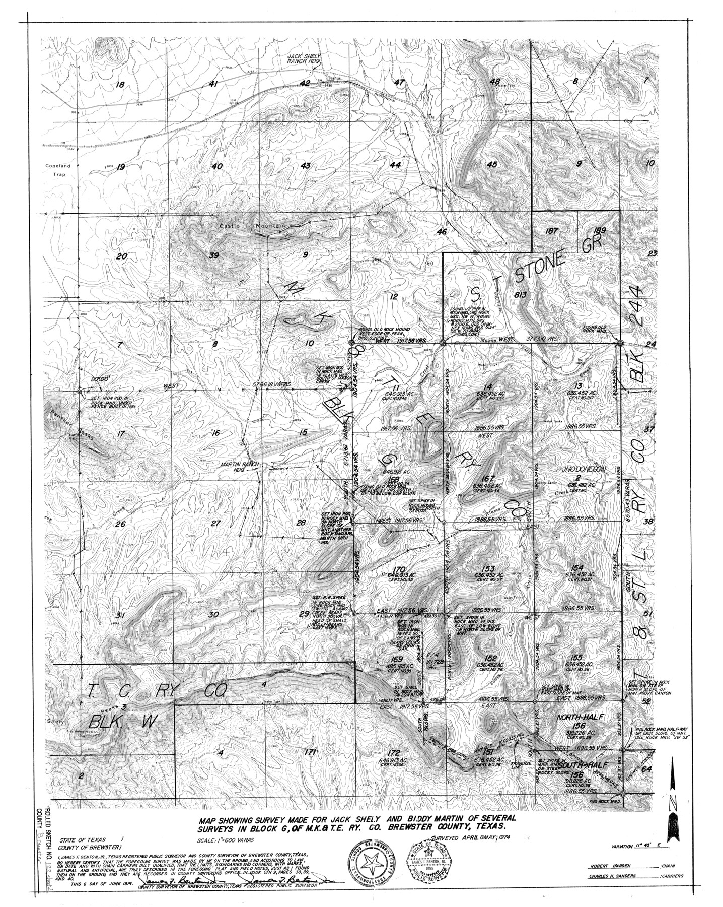
Map showing survey made for Jack Shely and Biddy Martin of several surveys in Block G, of M. K. & T. E. Ry. Co. Brewster County, Texas (Sheet 2 of 3)
-
Map/Doc
5297
-
Collection
General Map Collection
-
Object Dates
1974/6/6 (Creation Date)
-
People and Organizations
James F. Benton, Jr. (Surveyor/Engineer)
Robert Harden (Chainman/Field Personnel)
Charles H. Sanders (Chainman/Field Personnel)
-
Counties
Brewster
-
Subjects
Surveying Rolled Sketch
-
Height x Width
32.0 x 25.5 inches
81.3 x 64.8 cm
-
Scale
1" = 600 varas
-
Comments
For other sheets see 5296 and 5298.
Related maps
Brewster County Rolled Sketch 122

Print $20.00
- Digital $50.00
Brewster County Rolled Sketch 122
1974
Size 33.4 x 24.8 inches
Map/Doc 5296
Brewster County Rolled Sketch 122

Print $20.00
- Digital $50.00
Brewster County Rolled Sketch 122
1974
Size 31.9 x 24.6 inches
Map/Doc 5298
Part of: General Map Collection
El Paso County Rolled Sketch 52

Print $20.00
- Digital $50.00
El Paso County Rolled Sketch 52
1960
Size 18.4 x 24.4 inches
Map/Doc 5841
Runnels County Sketch File 18

Print $10.00
Runnels County Sketch File 18
1892
Size 14.0 x 8.4 inches
Map/Doc 35476
Blanco County Working Sketch 1

Print $20.00
- Digital $50.00
Blanco County Working Sketch 1
Size 31.1 x 17.4 inches
Map/Doc 76449
Map of Hutchinson County

Print $20.00
- Digital $50.00
Map of Hutchinson County
1898
Size 41.0 x 35.4 inches
Map/Doc 16856
Tanglewood, Station Map-Tracks & Structures-Lands, San Antonio & Aransas Pass Railway Co., Station 4804+179 to Station 4856+179

Print $4.00
- Digital $50.00
Tanglewood, Station Map-Tracks & Structures-Lands, San Antonio & Aransas Pass Railway Co., Station 4804+179 to Station 4856+179
1919
Size 11.7 x 18.6 inches
Map/Doc 62569
Brazoria County Sketch File 59

Print $364.00
- Digital $50.00
Brazoria County Sketch File 59
1996
Size 14.9 x 8.3 inches
Map/Doc 15398
Hill County Working Sketch 4

Print $20.00
- Digital $50.00
Hill County Working Sketch 4
1982
Size 25.3 x 23.3 inches
Map/Doc 66190
South Part Brewster Co.

Print $40.00
- Digital $50.00
South Part Brewster Co.
1915
Size 39.2 x 51.8 inches
Map/Doc 4760
Schleicher County Working Sketch 6

Print $20.00
- Digital $50.00
Schleicher County Working Sketch 6
1917
Size 24.6 x 19.3 inches
Map/Doc 63808
Aransas County Sketch File 21b

Print $4.00
- Digital $50.00
Aransas County Sketch File 21b
Size 8.7 x 14.2 inches
Map/Doc 13160
Aransas County Working Sketch 16

Print $40.00
- Digital $50.00
Aransas County Working Sketch 16
1965
Size 55.3 x 43.1 inches
Map/Doc 67183
Reagan County Rolled Sketch 8

Print $20.00
- Digital $50.00
Reagan County Rolled Sketch 8
Size 30.2 x 26.7 inches
Map/Doc 7436
You may also like
Coleman County Working Sketch 18

Print $20.00
- Digital $50.00
Coleman County Working Sketch 18
1952
Size 24.6 x 34.8 inches
Map/Doc 68084
Dallas County Boundary File 3

Print $6.00
- Digital $50.00
Dallas County Boundary File 3
Size 14.2 x 8.6 inches
Map/Doc 52120
Typical Scenes of Wichita Falls and District

Print $20.00
- Digital $50.00
Typical Scenes of Wichita Falls and District
1927
Size 13.7 x 16.6 inches
Map/Doc 96761
Comanche County Sketch File 8

Print $4.00
- Digital $50.00
Comanche County Sketch File 8
1853
Size 13.1 x 8.2 inches
Map/Doc 19066
Galveston County Sketch File 26

Print $4.00
- Digital $50.00
Galveston County Sketch File 26
1860
Size 11.8 x 5.7 inches
Map/Doc 23397
General Highway Map, Hidalgo County, Texas

Print $20.00
General Highway Map, Hidalgo County, Texas
1961
Size 18.2 x 24.8 inches
Map/Doc 79519
Flight Mission No. BQY-15M, Frame 4, Harris County

Print $20.00
- Digital $50.00
Flight Mission No. BQY-15M, Frame 4, Harris County
1953
Size 18.6 x 22.4 inches
Map/Doc 85302

[Sections 58-63, I. & G. N. Block 1 and area adjacent to the west]
![91637, [Sections 58-63, I. & G. N. Block 1 and area adjacent to the west], Twichell Survey Records](https://historictexasmaps.com/wmedia_w700/maps/91637-1.tif.jpg)
Print $20.00
- Digital $50.00
[Sections 58-63, I. & G. N. Block 1 and area adjacent to the west]
Size 23.0 x 15.3 inches
Map/Doc 91637
Amistad International Reservoir on Rio Grande 109

Print $20.00
- Digital $50.00
Amistad International Reservoir on Rio Grande 109
1950
Size 28.6 x 41.3 inches
Map/Doc 75540
Map of the territory comprised between the Province of New Mexico and the fort of Natchitoches and Texas

Map of the territory comprised between the Province of New Mexico and the fort of Natchitoches and Texas
1789
Size 8.9 x 15.3 inches
Map/Doc 88888
Flight Mission No. BQR-3K, Frame 158, Brazoria County

Print $20.00
- Digital $50.00
Flight Mission No. BQR-3K, Frame 158, Brazoria County
1952
Size 18.7 x 22.4 inches
Map/Doc 83985