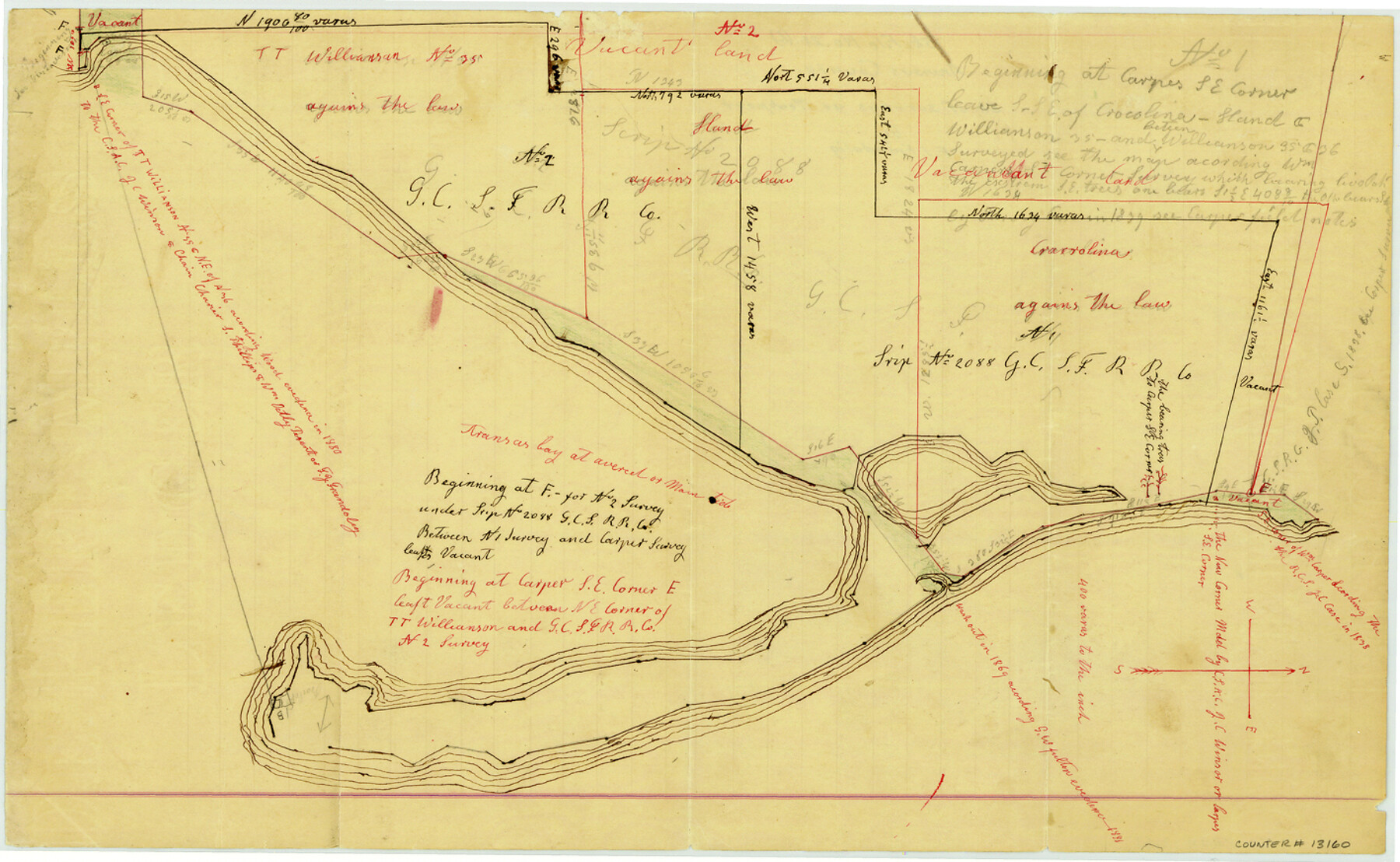
Aransas County Sketch File 21b
[Sketch of surveys at Rockport]
-
Map/Doc
13160
-
Collection
General Map Collection
-
People and Organizations
F.J. Frandolig (Surveyor/Engineer)
-
Counties
Aransas
-
Subjects
Surveying Sketch File
-
Height x Width
8.7 x 14.2 inches
22.1 x 36.1 cm
-
Medium
paper, manuscript
Part of: General Map Collection
Oldham County Boundary File 3

Print $80.00
- Digital $50.00
Oldham County Boundary File 3
Size 20.0 x 58.0 inches
Map/Doc 57771
Northwest Part Pecos County

Print $20.00
- Digital $50.00
Northwest Part Pecos County
1975
Size 43.4 x 44.2 inches
Map/Doc 95612
Burnet County Working Sketch 6

Print $20.00
- Digital $50.00
Burnet County Working Sketch 6
1958
Size 20.5 x 31.0 inches
Map/Doc 67849
Edwards County Working Sketch 5

Print $20.00
- Digital $50.00
Edwards County Working Sketch 5
1907
Size 14.9 x 23.4 inches
Map/Doc 68881
The Texas & Oklahoma Official Railway & Hotel Guide Map

Print $20.00
- Digital $50.00
The Texas & Oklahoma Official Railway & Hotel Guide Map
1917
Size 23.6 x 24.1 inches
Map/Doc 94032
Map of that part of Comal County in Bexar District

Print $20.00
- Digital $50.00
Map of that part of Comal County in Bexar District
Size 16.3 x 22.1 inches
Map/Doc 3431
Nacogdoches County Sketch File 2

Print $4.00
- Digital $50.00
Nacogdoches County Sketch File 2
1852
Size 8.0 x 6.4 inches
Map/Doc 32235
Culberson Co.

Print $40.00
- Digital $50.00
Culberson Co.
1908
Size 49.0 x 32.9 inches
Map/Doc 66796
Matagorda County Rolled Sketch 18A

Print $20.00
- Digital $50.00
Matagorda County Rolled Sketch 18A
1838
Size 35.4 x 30.1 inches
Map/Doc 6686
Harris County Rolled Sketch O

Print $20.00
- Digital $50.00
Harris County Rolled Sketch O
1913
Size 16.0 x 24.5 inches
Map/Doc 6140
Nacogdoches County Sketch File 1

Print $4.00
- Digital $50.00
Nacogdoches County Sketch File 1
Size 10.2 x 7.8 inches
Map/Doc 32233
Sutton County Sketch File 22

Print $4.00
- Digital $50.00
Sutton County Sketch File 22
Size 14.2 x 8.5 inches
Map/Doc 37459
You may also like
[Blks. Z, C4, 194, 178, C3, A2, 179 and 207]
![89837, [Blks. Z, C4, 194, 178, C3, A2, 179 and 207], Twichell Survey Records](https://historictexasmaps.com/wmedia_w700/maps/89837-1.tif.jpg)
Print $40.00
- Digital $50.00
[Blks. Z, C4, 194, 178, C3, A2, 179 and 207]
Size 61.6 x 37.5 inches
Map/Doc 89837
Map of Washington District

Print $20.00
- Digital $50.00
Map of Washington District
1847
Size 17.6 x 26.8 inches
Map/Doc 4125
Brooks County Rolled Sketch 7

Print $20.00
- Digital $50.00
Brooks County Rolled Sketch 7
1916
Size 28.5 x 30.4 inches
Map/Doc 5336

Coast Chart No. 210 - Aransas Pass and Corpus Christi Bay with the coast to latitude 27° 12', Texas

Print $20.00
- Digital $50.00
Coast Chart No. 210 - Aransas Pass and Corpus Christi Bay with the coast to latitude 27° 12', Texas
1913
Size 18.1 x 23.4 inches
Map/Doc 73455
City of Austin, Texas - Use District Map

Print $20.00
- Digital $50.00
City of Austin, Texas - Use District Map
1943
Size 38.9 x 25.7 inches
Map/Doc 95705
Matagorda County Sketch File 12

Print $2.00
- Digital $50.00
Matagorda County Sketch File 12
Size 8.4 x 7.0 inches
Map/Doc 30771
Shelby County Rolled Sketch 20

Print $20.00
- Digital $50.00
Shelby County Rolled Sketch 20
1983
Size 24.7 x 37.2 inches
Map/Doc 7785
Red River Co.

Print $20.00
- Digital $50.00
Red River Co.
1897
Size 46.7 x 36.9 inches
Map/Doc 78402
Ed Gordon Irrigated Farm NE Quarter Section 14, Block E

Print $20.00
- Digital $50.00
Ed Gordon Irrigated Farm NE Quarter Section 14, Block E
1943
Size 16.0 x 18.6 inches
Map/Doc 92325
Van Zandt County Rolled Sketch 5

Print $20.00
- Digital $50.00
Van Zandt County Rolled Sketch 5
1946
Size 27.1 x 28.1 inches
Map/Doc 8146
Wichita County Sketch File 7

Print $2.00
- Digital $50.00
Wichita County Sketch File 7
Size 7.5 x 13.9 inches
Map/Doc 40047