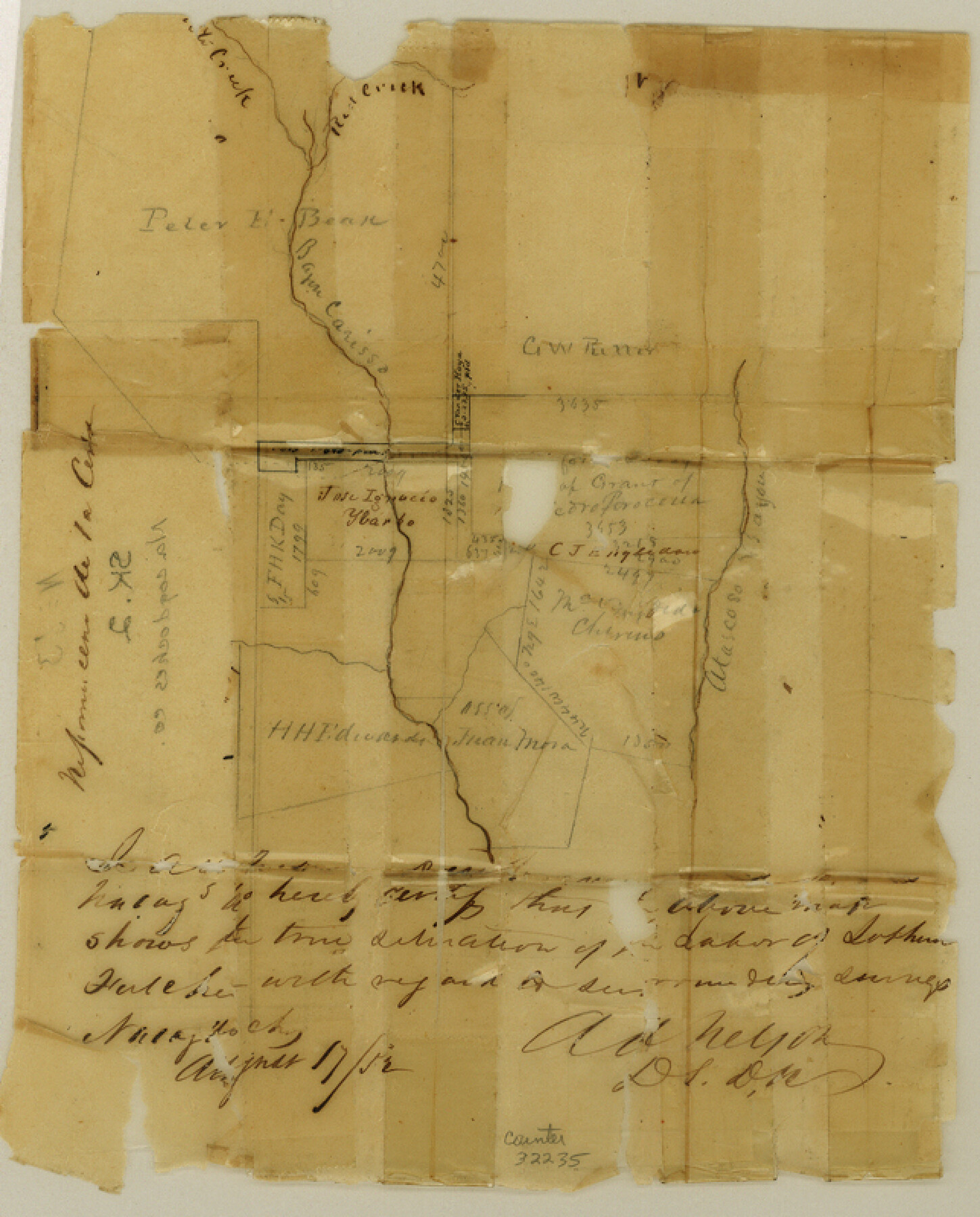
Nacogdoches County Sketch File 2
[Sketch southeast of Nacogdoches on Carisso Creek]
- 
                          Map/Doc32235
- 
                            CollectionGeneral Map Collection
- 
                            Object Dates1858 (File Date)8/17/1852 (Creation Date)
- 
                            People and OrganizationsA.A. Nelson (Surveyor/Engineer)
- 
                            CountiesNacogdoches
- 
                            SubjectsSurveying Sketch File
- 
                            Height x Width8.0 x 6.4 inches20.3 x 16.3 cm
- 
                            Mediumpaper, manuscript
- 
                            FeaturesBayou CarrisoRed CreekAtascoso Bayou
Part of: General Map Collection
            Sutton County Rolled Sketch 71


                                            Print $20.00                    
                                             -                         Digital $50.00                                    
                Sutton County Rolled Sketch 71
Size 23.1 x 35.3 inches
                                Map/Doc 83760
            
            Chambers County Sketch File 43


                                            Print $13.00                    
                                             -                         Digital $50.00                                    
                Chambers County Sketch File 43
Size 14.3 x 9.6 inches
                                Map/Doc 17729
            
            Brewster County Rolled Sketch 46


                                            Print $20.00                    
                                             -                         Digital $50.00                                    
                Brewster County Rolled Sketch 46
Size 20.8 x 32.2 inches
                                Map/Doc 5222
            
            Rockwall County Working Sketch 4


                                            Print $20.00                    
                                             -                         Digital $50.00                                    
                Rockwall County Working Sketch 4
1966
Size 34.9 x 28.9 inches
                                Map/Doc 63596
            
            Karte von den Vermessungen im Grant und in der Gegend zwischen demselben und Neu Braunfels


                                            Print $20.00                    
                                             -                         Digital $50.00                                    
                Karte von den Vermessungen im Grant und in der Gegend zwischen demselben und Neu Braunfels
1850
Size 24.0 x 19.0 inches
                                Map/Doc 94446
            
            Goliad Station Map, Galveston, Harrisburg & San Antonio Ry. operated by the T. & N. O. R.R. Co.


                                            Print $40.00                    
                                             -                         Digital $50.00                                    
                Goliad Station Map, Galveston, Harrisburg & San Antonio Ry. operated by the T. & N. O. R.R. Co.
1918
Size 24.7 x 55.8 inches
                                Map/Doc 76161
            
            Crockett County Sketch File 23


                                            Print $2.00                    
                                             -                         Digital $50.00                                    
                Crockett County Sketch File 23
Size 8.6 x 8.5 inches
                                Map/Doc 19697
            
            Burnet County Sketch File 11


                                            Print $40.00                    
                                             -                         Digital $50.00                                    
                Burnet County Sketch File 11
1848
Size 12.8 x 15.2 inches
                                Map/Doc 16692
            
            Harris County Historic Topographic 34


                                            Print $20.00                    
                                             -                         Digital $50.00                                    
                Harris County Historic Topographic 34
1915
Size 19.7 x 23.7 inches
                                Map/Doc 65845
            
            Comal County Sketch File 10


                                            Print $4.00                    
                                             -                         Digital $50.00                                    
                Comal County Sketch File 10
1849
Size 12.7 x 7.6 inches
                                Map/Doc 19020
            
            Loving County Working Sketch 1


                                            Print $20.00                    
                                             -                         Digital $50.00                                    
                Loving County Working Sketch 1
1928
Size 30.0 x 19.7 inches
                                Map/Doc 70633
            You may also like
            Flight Mission No. CGI-4N, Frame 193, Cameron County


                                            Print $20.00                    
                                             -                         Digital $50.00                                    
                Flight Mission No. CGI-4N, Frame 193, Cameron County
1955
Size 18.6 x 22.3 inches
                                Map/Doc 84696
            
            Roberts County Sketch File 7


                                            Print $16.00                    
                                             -                         Digital $50.00                                    
                Roberts County Sketch File 7
1992
Size 14.3 x 8.8 inches
                                Map/Doc 35316
            
            Edwards County Boundary File 1


                                            Print $18.00                    
                                             -                         Digital $50.00                                    
                Edwards County Boundary File 1
Size 15.5 x 5.5 inches
                                Map/Doc 52853
            
            Collin County Boundary File 18c


                                            Print $12.00                    
                                             -                         Digital $50.00                                    
                Collin County Boundary File 18c
Size 12.9 x 8.1 inches
                                Map/Doc 51733
            
            Parker County Sketch File 31


                                            Print $6.00                    
                                             -                         Digital $50.00                                    
                Parker County Sketch File 31
1877
Size 9.9 x 9.8 inches
                                Map/Doc 33572
            
            Plat of a survey on Padre Island in Willacy County surveyed for South Padre Development Corporation by Settles and Claunch


                                            Print $40.00                    
                                             -                         Digital $50.00                                    
                Plat of a survey on Padre Island in Willacy County surveyed for South Padre Development Corporation by Settles and Claunch
1966
Size 78.6 x 41.6 inches
                                Map/Doc 61427
            
            Val Verde County Working Sketch 68


                                            Print $20.00                    
                                             -                         Digital $50.00                                    
                Val Verde County Working Sketch 68
1965
Size 37.3 x 44.2 inches
                                Map/Doc 72203
            
            [Surveys in Austin's Colony along the Brazos River and Oyster Creek]
            
                                    ![206, [Surveys in Austin's Colony along the Brazos River and Oyster Creek], General Map Collection](https://historictexasmaps.com/wmedia_w700/maps/206.tif.jpg) 


    ![206, [Surveys in Austin's Colony along the Brazos River and Oyster Creek], General Map Collection](https://historictexasmaps.com/wmedia_w700/maps/206.tif.jpg) 
                                
            
                                            Print $20.00                    
                                             -                         Digital $50.00                                    
                [Surveys in Austin's Colony along the Brazos River and Oyster Creek]
1824
Size 23.1 x 17.2 inches
                                Map/Doc 206
            
            General Highway Map, Bexar County, Texas


                                            Print $20.00                    
                                    
                General Highway Map, Bexar County, Texas
1940
Size 18.4 x 25.1 inches
                                Map/Doc 79016
            
            Crockett County Working Sketch 65


                                            Print $20.00                    
                                             -                         Digital $50.00                                    
                Crockett County Working Sketch 65
1957
Size 32.3 x 38.0 inches
                                Map/Doc 68398
            
            McMullen County Working Sketch 58


                                            Print $40.00                    
                                             -                         Digital $50.00                                    
                McMullen County Working Sketch 58
1984
Size 61.2 x 40.0 inches
                                Map/Doc 70759
            
            Current Miscellaneous File 61


                                            Print $4.00                    
                                             -                         Digital $50.00                                    
                Current Miscellaneous File 61
1956
Size 9.3 x 13.6 inches
                                Map/Doc 74066
             
                            