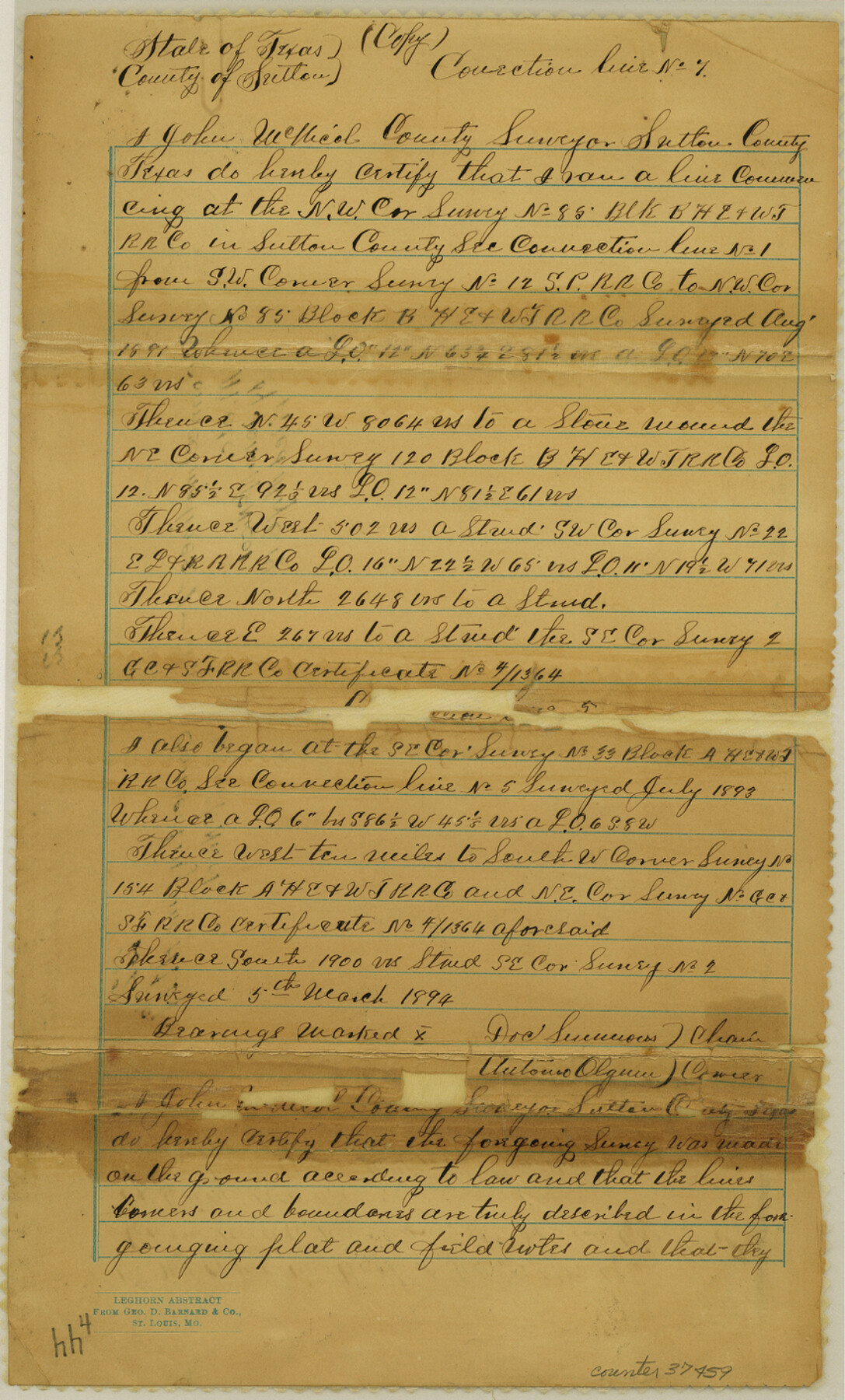
Sutton County Sketch File 22
[Connecting lines numbers 7, 5, A1, etc]
-
Map/Doc
37459
-
Collection
General Map Collection
-
Object Dates
1918/5/6 (File Date)
1891 (Survey Date)
1894/3/5 (Survey Date)
-
People and Organizations
John McNicol (Surveyor/Engineer)
Doc Simmons (Chainman/Field Personnel)
Antonio Oiguin (Chainman/Field Personnel)
-
Counties
Sutton
-
Subjects
Surveying Sketch File
-
Height x Width
14.2 x 8.5 inches
36.1 x 21.6 cm
-
Medium
paper, manuscript
Part of: General Map Collection
El Paso County Sketch File 37

Print $4.00
- Digital $50.00
El Paso County Sketch File 37
1987
Size 14.4 x 9.1 inches
Map/Doc 22221
Brazoria County Working Sketch 4

Print $20.00
- Digital $50.00
Brazoria County Working Sketch 4
1920
Size 20.4 x 28.6 inches
Map/Doc 67489
Jeff Davis County Sketch File 41

Print $40.00
- Digital $50.00
Jeff Davis County Sketch File 41
1959
Size 13.3 x 13.4 inches
Map/Doc 28064
Hale County Boundary File 1

Print $44.00
- Digital $50.00
Hale County Boundary File 1
Size 10.0 x 30.9 inches
Map/Doc 54031
El Paso County Rolled Sketch 57B

Print $40.00
- Digital $50.00
El Paso County Rolled Sketch 57B
1984
Size 49.0 x 37.1 inches
Map/Doc 8880
Frio County Working Sketch 15

Print $20.00
- Digital $50.00
Frio County Working Sketch 15
1961
Size 31.2 x 43.5 inches
Map/Doc 69289
Orange County Working Sketch 44

Print $20.00
- Digital $50.00
Orange County Working Sketch 44
1980
Size 16.5 x 22.0 inches
Map/Doc 71376
Flight Mission No. DQO-2K, Frame 141, Galveston County

Print $20.00
- Digital $50.00
Flight Mission No. DQO-2K, Frame 141, Galveston County
1952
Size 18.9 x 22.5 inches
Map/Doc 85038
Flight Mission No. DAG-24K, Frame 161, Matagorda County

Print $20.00
- Digital $50.00
Flight Mission No. DAG-24K, Frame 161, Matagorda County
1953
Size 18.6 x 22.5 inches
Map/Doc 86575
Map showing the fortification at Point Isabel

Print $20.00
- Digital $50.00
Map showing the fortification at Point Isabel
1864
Size 18.3 x 27.9 inches
Map/Doc 72921
Amistad International Reservoir on Rio Grande 91

Print $20.00
- Digital $50.00
Amistad International Reservoir on Rio Grande 91
1950
Size 28.5 x 41.0 inches
Map/Doc 75521
Hutchinson County Working Sketch 45

Print $20.00
- Digital $50.00
Hutchinson County Working Sketch 45
1979
Size 20.3 x 17.5 inches
Map/Doc 66405
You may also like
Colorado County Sketch File 17

Print $22.00
- Digital $50.00
Colorado County Sketch File 17
Size 8.7 x 7.7 inches
Map/Doc 18949
Erath County Rolled Sketch 4

Print $20.00
- Digital $50.00
Erath County Rolled Sketch 4
Size 29.1 x 40.9 inches
Map/Doc 5866
Brewster County Sketch File N-26

Print $40.00
- Digital $50.00
Brewster County Sketch File N-26
Size 20.5 x 15.4 inches
Map/Doc 10971
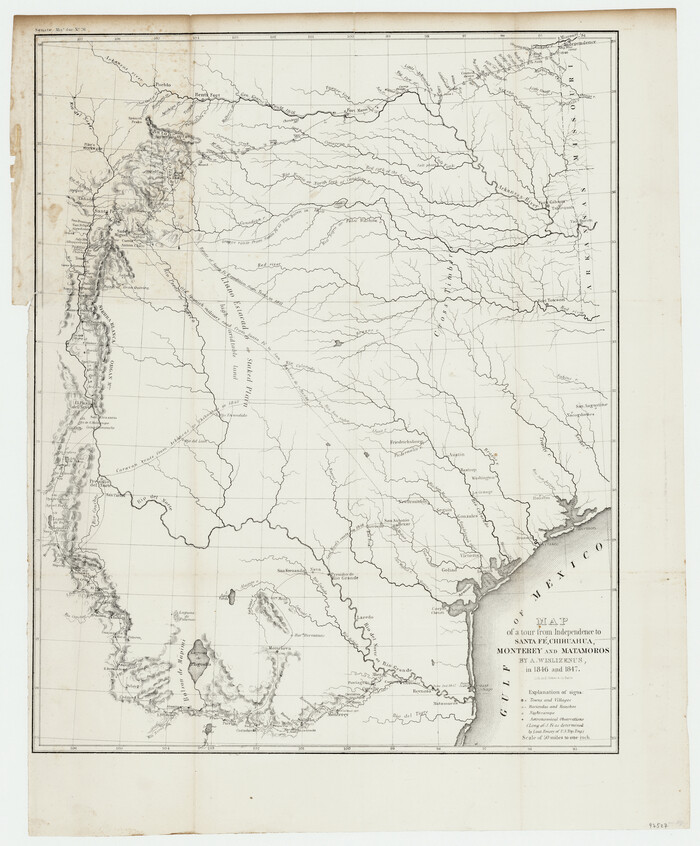
Map of a tour from Independence to Santa Fé, Chihuahua, Monterey and Matamoros by A. Wislizenus, in 1846 and 1847
Print $20.00
- Digital $50.00
Map of a tour from Independence to Santa Fé, Chihuahua, Monterey and Matamoros by A. Wislizenus, in 1846 and 1847
1848
Size 23.2 x 19.2 inches
Map/Doc 97527
Jim Hogg County Sketch File 4

Print $8.00
- Digital $50.00
Jim Hogg County Sketch File 4
1926
Size 11.2 x 8.7 inches
Map/Doc 28404
[Sketch of Plans and Bill of Material for 38' x 40' Texas Highway Dept. Warehouse]
![450, [Sketch of Plans and Bill of Material for 38' x 40' Texas Highway Dept. Warehouse], Maddox Collection](https://historictexasmaps.com/wmedia_w700/maps/450.tif.jpg)
Print $20.00
- Digital $50.00
[Sketch of Plans and Bill of Material for 38' x 40' Texas Highway Dept. Warehouse]
Size 23.7 x 22.8 inches
Map/Doc 450
Yoakum County Sketch File 19

Print $18.00
- Digital $50.00
Yoakum County Sketch File 19
1898
Size 11.5 x 8.8 inches
Map/Doc 40832
Map of Travis County

Print $20.00
- Digital $50.00
Map of Travis County
1861
Size 21.2 x 25.3 inches
Map/Doc 4087
Potter County Boundary File 5

Print $24.00
- Digital $50.00
Potter County Boundary File 5
Size 15.0 x 9.4 inches
Map/Doc 58013
Points of Interest & Road Map of Scenicland, U.S.A. and United States [Recto]
![94192, Points of Interest & Road Map of Scenicland, U.S.A. and United States [Recto], General Map Collection](https://historictexasmaps.com/wmedia_w700/maps/94192.tif.jpg)
Points of Interest & Road Map of Scenicland, U.S.A. and United States [Recto]
1966
Size 34.7 x 22.4 inches
Map/Doc 94192
Navarro County

Print $40.00
- Digital $50.00
Navarro County
1924
Size 41.1 x 48.2 inches
Map/Doc 77382
Scurry County Sketch File 3

Print $20.00
- Digital $50.00
Scurry County Sketch File 3
Size 22.0 x 24.2 inches
Map/Doc 12312