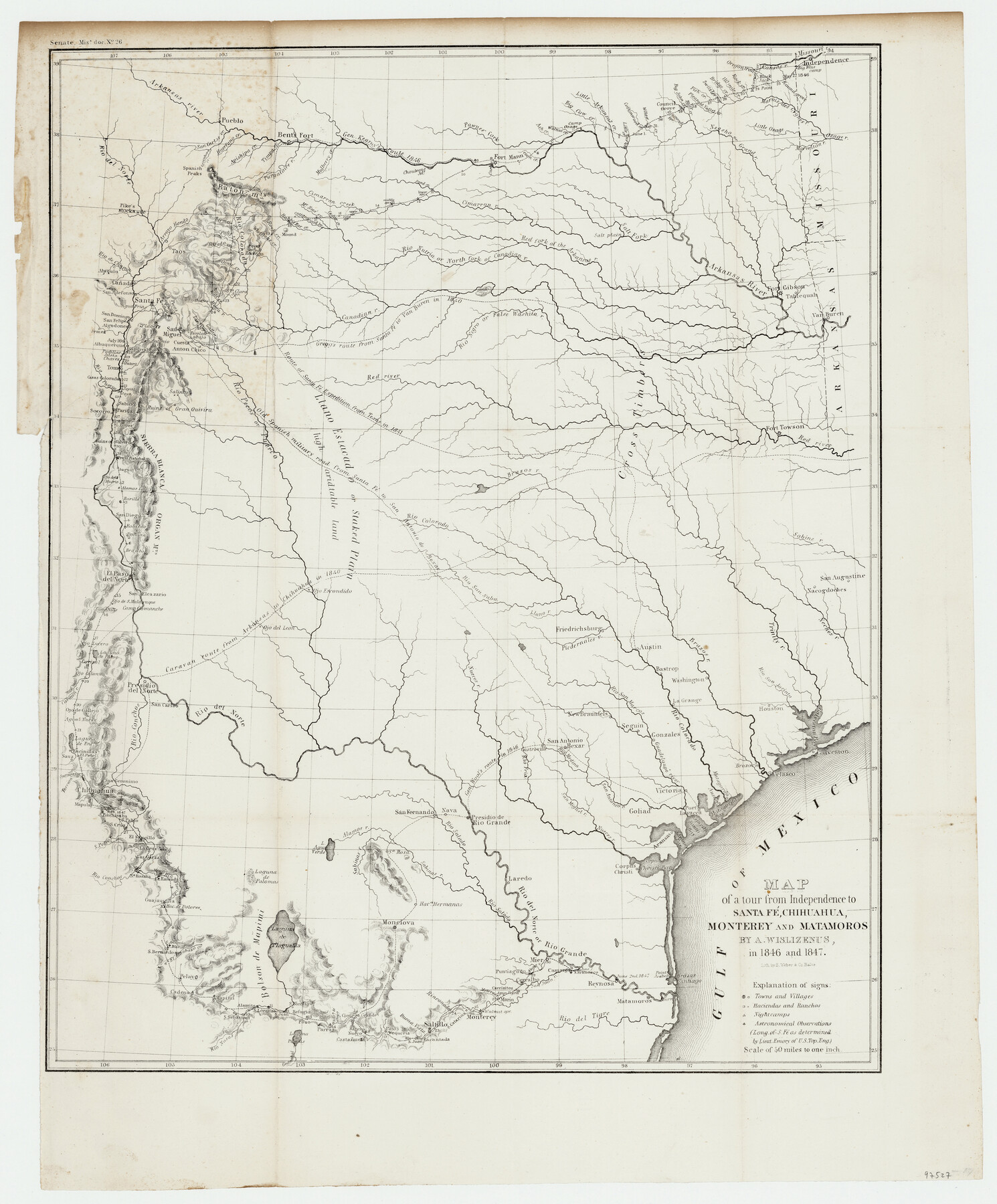
Map of a tour from Independence to Santa Fé, Chihuahua, Monterey and Matamoros by A. Wislizenus, in 1846 and 1847
-
Map/Doc
97527
-
Collection
General Map Collection
-
Object Dates
1848 (Creation Date)
-
People and Organizations
Frederick A. Wislizenus (Author)
E. Weber and Company (Lithographer)
-
Subjects
State of Texas
-
Height x Width
23.2 x 19.2 inches
58.9 x 48.8 cm
-
Comments
This map accompanied Wislizenus' "Memoir of a Tour to Northern Mexico". To view/download the english translation of this memoir please click the "Download PDF" link above.
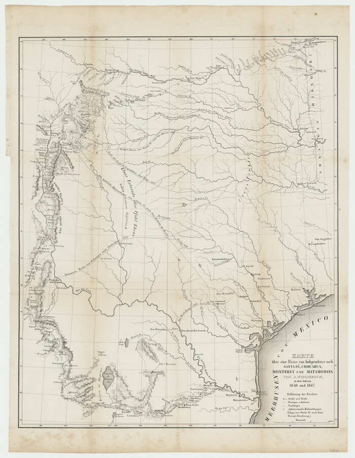
To view the German version of this map, please see "Karte über eine Reise von Independence nach Santa Fé, Chihuahua, Monterey und Matamoros" (Map 97528). To view a German version of the memoir, see 97531.
Related maps
Karte über eine Reise von Independence nach Santa Fé, Chihuahua, Monterey und Matamoros von A. Wislizenus, in den Jahren 1846 und 1847
Print $20.00
- Digital $50.00
Karte über eine Reise von Independence nach Santa Fé, Chihuahua, Monterey und Matamoros von A. Wislizenus, in den Jahren 1846 und 1847
1850
Size 22.6 x 17.5 inches
Map/Doc 97528
Denkschrift Uber Eine Reise Nach Nord-Mexiko, Verbunden mit der Expedition des Obersten Doniphan, in den Jahren 1846 und 1847
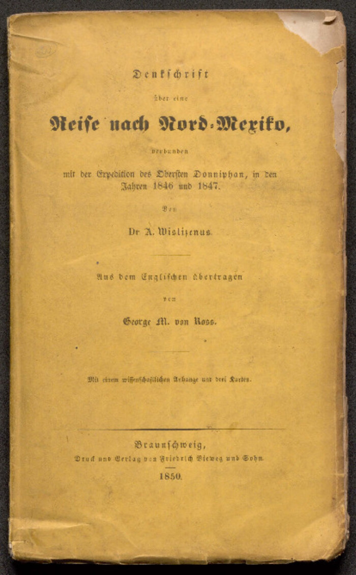
Denkschrift Uber Eine Reise Nach Nord-Mexiko, Verbunden mit der Expedition des Obersten Doniphan, in den Jahren 1846 und 1847
1850
Map/Doc 97531
Part of: General Map Collection
[Surveys in Power and Hewetson's Colony]
![2, [Surveys in Power and Hewetson's Colony], General Map Collection](https://historictexasmaps.com/wmedia_w700/maps/2.tif.jpg)
Print $20.00
- Digital $50.00
[Surveys in Power and Hewetson's Colony]
1830
Size 21.3 x 22.5 inches
Map/Doc 2
Terrell County Working Sketch 43

Print $20.00
- Digital $50.00
Terrell County Working Sketch 43
1957
Size 45.0 x 38.4 inches
Map/Doc 62136
Flight Mission No. DQN-5K, Frame 45, Calhoun County

Print $20.00
- Digital $50.00
Flight Mission No. DQN-5K, Frame 45, Calhoun County
1953
Size 18.4 x 22.1 inches
Map/Doc 84390
Intracoastal Waterway, Houma, LA to Corpus Christi, TX

Print $5.00
- Digital $50.00
Intracoastal Waterway, Houma, LA to Corpus Christi, TX
Size 29.3 x 22.0 inches
Map/Doc 61909
Flight Mission No. DQO-7K, Frame 99, Galveston County

Print $20.00
- Digital $50.00
Flight Mission No. DQO-7K, Frame 99, Galveston County
1952
Size 18.7 x 22.5 inches
Map/Doc 85114

Ward County Rolled Sketch 28

Print $20.00
- Digital $50.00
Ward County Rolled Sketch 28
Size 22.3 x 27.5 inches
Map/Doc 8167
Scurry County Rolled Sketch 9

Print $20.00
- Digital $50.00
Scurry County Rolled Sketch 9
1963
Size 23.0 x 22.0 inches
Map/Doc 7769
Kerr County Rolled Sketch 18

Print $20.00
- Digital $50.00
Kerr County Rolled Sketch 18
1954
Size 33.4 x 28.8 inches
Map/Doc 6500
Hill County Sketch File 10

Print $4.00
- Digital $50.00
Hill County Sketch File 10
1859
Size 7.1 x 8.2 inches
Map/Doc 26478
Frio County Sketch File 23

Print $6.00
- Digital $50.00
Frio County Sketch File 23
2013
Size 11.0 x 8.5 inches
Map/Doc 93418
Map of Wilbarger County Young Land District formerly Fannin Land District

Print $20.00
- Digital $50.00
Map of Wilbarger County Young Land District formerly Fannin Land District
1859
Size 22.7 x 20.6 inches
Map/Doc 4146
You may also like
Jasper County Sketch File 12

Print $4.00
- Digital $50.00
Jasper County Sketch File 12
Size 8.8 x 10.0 inches
Map/Doc 27792
El Paso County Sketch File 1

Print $48.00
- Digital $50.00
El Paso County Sketch File 1
1849
Size 8.9 x 8.2 inches
Map/Doc 21883
Fisher County Working Sketch 2

Print $20.00
- Digital $50.00
Fisher County Working Sketch 2
1920
Size 23.0 x 18.2 inches
Map/Doc 69136
From Aransas Pass Eastward, Texas

Print $40.00
- Digital $50.00
From Aransas Pass Eastward, Texas
1866
Size 31.4 x 53.6 inches
Map/Doc 73426
Hunt County Boundary File 10

Print $14.00
- Digital $50.00
Hunt County Boundary File 10
Size 9.2 x 14.9 inches
Map/Doc 55255
Pecos County Sketch File 24

Print $22.00
- Digital $50.00
Pecos County Sketch File 24
Size 7.6 x 5.6 inches
Map/Doc 33680
Culberson County Rolled Sketch 41

Print $88.00
- Digital $50.00
Culberson County Rolled Sketch 41
1944
Size 57.5 x 46.0 inches
Map/Doc 8752
Flight Mission No. DCL-6C, Frame 7, Kenedy County

Print $20.00
- Digital $50.00
Flight Mission No. DCL-6C, Frame 7, Kenedy County
1943
Size 18.6 x 22.4 inches
Map/Doc 85867
Flight Mission No. BRA-8M, Frame 123, Jefferson County

Print $20.00
- Digital $50.00
Flight Mission No. BRA-8M, Frame 123, Jefferson County
1953
Size 18.7 x 22.3 inches
Map/Doc 85619
Photostat of section of hydrographic surveys H-5399, H-4822, H-470

Print $20.00
- Digital $50.00
Photostat of section of hydrographic surveys H-5399, H-4822, H-470
1933
Size 18.3 x 25.8 inches
Map/Doc 61156
Nueces County Sketch File 49

Print $20.00
- Digital $50.00
Nueces County Sketch File 49
1956
Size 32.4 x 17.1 inches
Map/Doc 42193
Newton County

Print $40.00
- Digital $50.00
Newton County
1946
Size 48.7 x 42.6 inches
Map/Doc 73250