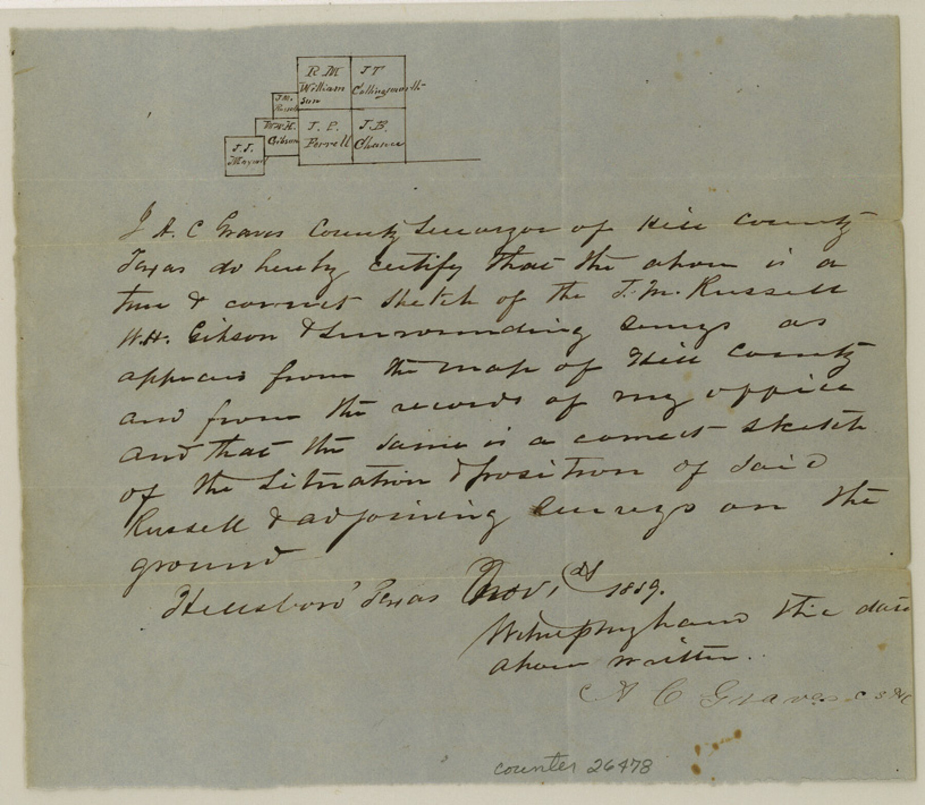
Hill County Sketch File 10
[Sketch from northwest of Hillsboro]
-
Map/Doc
26478
-
Collection
General Map Collection
-
Object Dates
11/1/1859 (Creation Date)
11/14/1859 (File Date)
-
People and Organizations
A.C. Graves (Surveyor/Engineer)
-
Counties
Hill
-
Subjects
Surveying Sketch File
-
Height x Width
7.1 x 8.2 inches
18.0 x 20.8 cm
-
Medium
paper, manuscript
Part of: General Map Collection
Jasper County Rolled Sketch 8

Print $20.00
- Digital $50.00
Jasper County Rolled Sketch 8
Size 17.7 x 12.0 inches
Map/Doc 6356
Flight Mission No. DAG-21K, Frame 121, Matagorda County

Print $20.00
- Digital $50.00
Flight Mission No. DAG-21K, Frame 121, Matagorda County
1952
Size 18.6 x 22.3 inches
Map/Doc 86447
Freestone County Working Sketch 29

Print $20.00
- Digital $50.00
Freestone County Working Sketch 29
1994
Size 36.0 x 45.5 inches
Map/Doc 69271
Martin County

Print $20.00
- Digital $50.00
Martin County
1933
Size 45.5 x 40.3 inches
Map/Doc 95580
Map of League City and Subdivisions comprising the M. Muldoon 2 League Grant and part of the S.F. Austin League east of G. H. & H. R.R.

Print $20.00
- Digital $50.00
Map of League City and Subdivisions comprising the M. Muldoon 2 League Grant and part of the S.F. Austin League east of G. H. & H. R.R.
1893
Size 27.7 x 37.4 inches
Map/Doc 87500
Edwards County Working Sketch 30

Print $20.00
- Digital $50.00
Edwards County Working Sketch 30
1947
Size 27.7 x 38.2 inches
Map/Doc 68906
Aransas County Working Sketch 5

Print $20.00
- Digital $50.00
Aransas County Working Sketch 5
1928
Size 19.7 x 23.2 inches
Map/Doc 67172
Panola County Working Sketch 34

Print $20.00
- Digital $50.00
Panola County Working Sketch 34
1983
Map/Doc 71443

Intracoastal Waterway in Texas - Corpus Christi to Point Isabel including Arroyo Colorado to Mo. Pac. R.R. Bridge Near Harlingen

Print $20.00
- Digital $50.00
Intracoastal Waterway in Texas - Corpus Christi to Point Isabel including Arroyo Colorado to Mo. Pac. R.R. Bridge Near Harlingen
1934
Size 21.8 x 32.7 inches
Map/Doc 61885
Map of Briscoe County

Print $20.00
- Digital $50.00
Map of Briscoe County
1885
Size 24.4 x 20.1 inches
Map/Doc 3334
Bailey County Sketch File 7

Print $8.00
- Digital $50.00
Bailey County Sketch File 7
1913
Size 14.0 x 8.7 inches
Map/Doc 13958
You may also like
Lavaca County Working Sketch 16

Print $20.00
- Digital $50.00
Lavaca County Working Sketch 16
1977
Size 25.0 x 24.9 inches
Map/Doc 70369
J. O. Jones Land, Gaines County, Texas - Cedar Lake Meridian

Print $20.00
- Digital $50.00
J. O. Jones Land, Gaines County, Texas - Cedar Lake Meridian
Size 8.5 x 32.1 inches
Map/Doc 90792
[Sketch for Mineral Application 19443 - Brazos River]
![65682, [Sketch for Mineral Application 19443 - Brazos River], General Map Collection](https://historictexasmaps.com/wmedia_w700/maps/65682.tif.jpg)
Print $40.00
- Digital $50.00
[Sketch for Mineral Application 19443 - Brazos River]
1853
Size 117.6 x 30.2 inches
Map/Doc 65682
Andrews County Rolled Sketch 20

Print $20.00
- Digital $50.00
Andrews County Rolled Sketch 20
Size 31.6 x 40.0 inches
Map/Doc 8395
General Highway Map, Duval County, Texas

Print $20.00
General Highway Map, Duval County, Texas
1961
Size 18.1 x 24.5 inches
Map/Doc 79449
Denison Dam Quadrangle

Print $20.00
- Digital $50.00
Denison Dam Quadrangle
1999
Size 35.4 x 23.4 inches
Map/Doc 97366
Orange County Sketch File 4a

Print $22.00
- Digital $50.00
Orange County Sketch File 4a
1874
Size 16.0 x 13.0 inches
Map/Doc 33309
Hardin County Sketch File 6

Print $4.00
- Digital $50.00
Hardin County Sketch File 6
Size 8.0 x 12.7 inches
Map/Doc 25097
Houston County Rolled Sketch 6

Print $40.00
- Digital $50.00
Houston County Rolled Sketch 6
1963
Size 48.0 x 34.3 inches
Map/Doc 9182
Flight Mission No. DIX-8P, Frame 85, Aransas County

Print $20.00
- Digital $50.00
Flight Mission No. DIX-8P, Frame 85, Aransas County
1956
Size 18.4 x 19.0 inches
Map/Doc 83910
Hays County Rolled Sketch 19

Print $20.00
- Digital $50.00
Hays County Rolled Sketch 19
1887
Size 26.7 x 22.3 inches
Map/Doc 6175
Montgomery County Sketch File 5

Print $5.00
- Digital $50.00
Montgomery County Sketch File 5
Size 9.8 x 16.4 inches
Map/Doc 31779