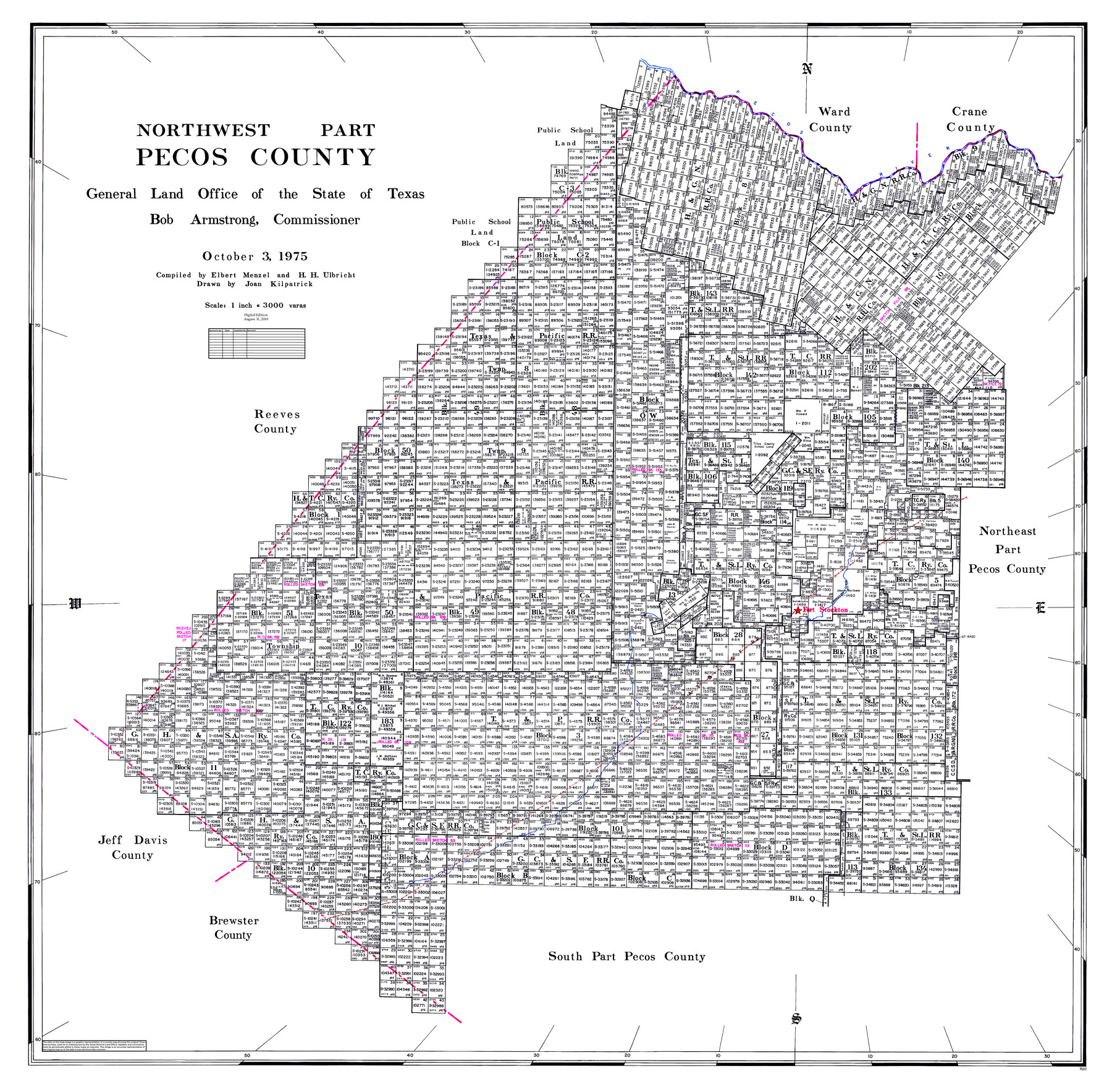
Northwest Part Pecos County
General Land Office Official County Map
- 
                          Map/Doc95612
- 
                            CollectionGeneral Map Collection
- 
                            Object Dates2019/8/31 (Revision Date)1975/10/3 (Creation Date)
- 
                            People and OrganizationsCheyenne Betancourt (Draftsman)Joan Kilpatrick (Draftsman)Elbert Menzel (Compiler)Herbert H. Ulbricht (Compiler)Bob Armstrong (GLO Commissioner)
- 
                            CountiesPecos
- 
                            SubjectsCounty OCM
- 
                            Height x Width43.4 x 44.2 inches110.2 x 112.3 cm
- 
                            Mediumdigital image
- 
                            Scale1" = 3000 varas
- 
                            CommentsFor northeast part of Pecos County see 95611 and for south part of Pecos County see 95613.
Related maps
            Northeast Part Pecos County


                                            Print $20.00                    
                                             -                         Digital $50.00                                    
                Northeast Part Pecos County
1975
Size 36.9 x 43.4 inches
                                Map/Doc 95611
            
            South Part Pecos County


                                            Print $20.00                    
                                             -                         Digital $50.00                                    
                South Part Pecos County
1976
Size 37.9 x 45.3 inches
                                Map/Doc 95613
            Part of: General Map Collection
            Carte de la Louisiane et du Cours du Mississipi


                                            Print $20.00                    
                                             -                         Digital $50.00                                    
                Carte de la Louisiane et du Cours du Mississipi
Size 21.7 x 28.6 inches
                                Map/Doc 95161
            
            No. 3 Chart of Channel connecting Corpus Christi Bay with Aransas Bay, Texas


                                            Print $20.00                    
                                             -                         Digital $50.00                                    
                No. 3 Chart of Channel connecting Corpus Christi Bay with Aransas Bay, Texas
1878
Size 18.1 x 27.9 inches
                                Map/Doc 72776
            
            Garza County Sketch File 22


                                            Print $40.00                    
                                             -                         Digital $50.00                                    
                Garza County Sketch File 22
Size 51.9 x 24.1 inches
                                Map/Doc 10464
            
            Goliad County Sketch File X


                                            Print $10.00                    
                                             -                         Digital $50.00                                    
                Goliad County Sketch File X
1893
Size 8.3 x 12.8 inches
                                Map/Doc 24332
            
            Austin County Rolled Sketch 4


                                            Print $20.00                    
                                             -                         Digital $50.00                                    
                Austin County Rolled Sketch 4
Size 30.8 x 44.8 inches
                                Map/Doc 8435
            
            Cottle County Working Sketch 22


                                            Print $40.00                    
                                             -                         Digital $50.00                                    
                Cottle County Working Sketch 22
1982
Size 44.0 x 75.0 inches
                                Map/Doc 68332
            
            Terrell County Sketch File 26


                                            Print $38.00                    
                                             -                         Digital $50.00                                    
                Terrell County Sketch File 26
1937
Size 10.9 x 8.2 inches
                                Map/Doc 37961
            
            Flight Mission No. DQO-3K, Frame 23, Galveston County


                                            Print $20.00                    
                                             -                         Digital $50.00                                    
                Flight Mission No. DQO-3K, Frame 23, Galveston County
1952
Size 18.8 x 22.5 inches
                                Map/Doc 85064
            
            [Sketch for Mineral Application 26546 - Sabine River between Hawkins Creek and east boundary line of BBB&C RR Co. Surveys, R. S. Rathke]
            
                                    ![65666, [Sketch for Mineral Application 26546 - Sabine River between Hawkins Creek and east boundary line of BBB&C RR Co. Surveys, R. S. Rathke], General Map Collection](https://historictexasmaps.com/wmedia_w700/maps/65666.tif.jpg) 


    ![65666, [Sketch for Mineral Application 26546 - Sabine River between Hawkins Creek and east boundary line of BBB&C RR Co. Surveys, R. S. Rathke], General Map Collection](https://historictexasmaps.com/wmedia_w700/maps/65666.tif.jpg) 
                                
            
                                            Print $40.00                    
                                             -                         Digital $50.00                                    
                [Sketch for Mineral Application 26546 - Sabine River between Hawkins Creek and east boundary line of BBB&C RR Co. Surveys, R. S. Rathke]
1931
Size 74.9 x 26.3 inches
                                Map/Doc 65666
            
            Hall County Rolled Sketch 7


                                            Print $20.00                    
                                             -                         Digital $50.00                                    
                Hall County Rolled Sketch 7
Size 9.2 x 26.4 inches
                                Map/Doc 6051
            
            Presidio County Working Sketch 28


                                            Print $20.00                    
                                             -                         Digital $50.00                                    
                Presidio County Working Sketch 28
1945
Size 19.9 x 13.4 inches
                                Map/Doc 71704
            
            Flight Mission No. CRC-4R, Frame 81, Chambers County


                                            Print $20.00                    
                                             -                         Digital $50.00                                    
                Flight Mission No. CRC-4R, Frame 81, Chambers County
1956
Size 18.7 x 22.5 inches
                                Map/Doc 84885
            You may also like
            Mills County Boundary File 2


                                            Print $6.00                    
                                             -                         Digital $50.00                                    
                Mills County Boundary File 2
Size 14.1 x 8.7 inches
                                Map/Doc 57278
            
            Childress County Rolled Sketch 9C


                                            Print $20.00                    
                                             -                         Digital $50.00                                    
                Childress County Rolled Sketch 9C
Size 13.8 x 17.9 inches
                                Map/Doc 5449
            
            General Highway Map.  Detail of Cities and Towns in Harris County, Texas


                                            Print $20.00                    
                                    
                General Highway Map. Detail of Cities and Towns in Harris County, Texas
1961
Size 18.2 x 24.6 inches
                                Map/Doc 79503
            
            [West half of County]
            
                                    ![89961, [West half of County], Twichell Survey Records](https://historictexasmaps.com/wmedia_w700/maps/89961-1.tif.jpg) 


    ![89961, [West half of County], Twichell Survey Records](https://historictexasmaps.com/wmedia_w700/maps/89961-1.tif.jpg) 
                                
            
                                            Print $40.00                    
                                             -                         Digital $50.00                                    
                [West half of County]
1914
Size 40.0 x 62.5 inches
                                Map/Doc 89961
            
            Sketch A Shewing the progress of the Survey in Section No. 1 From 1844 to 1851


                                            Print $20.00                    
                                             -                         Digital $50.00                                    
                Sketch A Shewing the progress of the Survey in Section No. 1 From 1844 to 1851
1851
Size 37.1 x 24.5 inches
                                Map/Doc 97202
            
            Young County Sketch File 3


                                            Print $4.00                    
                                             -                         Digital $50.00                                    
                Young County Sketch File 3
1854
Size 12.3 x 8.2 inches
                                Map/Doc 40847
            
            Sketch in Crockett County [showing University Land Blocks 42 and 45 and Block A-B]
            
                                    ![90313, Sketch in Crockett County [showing University Land Blocks 42 and 45 and Block A-B], Twichell Survey Records](https://historictexasmaps.com/wmedia_w700/maps/90313-1.tif.jpg) 


    ![90313, Sketch in Crockett County [showing University Land Blocks 42 and 45 and Block A-B], Twichell Survey Records](https://historictexasmaps.com/wmedia_w700/maps/90313-1.tif.jpg) 
                                
            
                                            Print $20.00                    
                                             -                         Digital $50.00                                    
                Sketch in Crockett County [showing University Land Blocks 42 and 45 and Block A-B]
1913
Size 24.6 x 11.9 inches
                                Map/Doc 90313
            
            [Brooks & Burleson Block 4, Hartley County]
            
                                    ![5037, [Brooks & Burleson Block 4, Hartley County], Maddox Collection](https://historictexasmaps.com/wmedia_w700/maps/5037.tif.jpg) 


    ![5037, [Brooks & Burleson Block 4, Hartley County], Maddox Collection](https://historictexasmaps.com/wmedia_w700/maps/5037.tif.jpg) 
                                
            
                                            Print $3.00                    
                                             -                         Digital $50.00                                    
                [Brooks & Burleson Block 4, Hartley County]
Size 10.3 x 9.5 inches
                                Map/Doc 5037
            
            Houston County Working Sketch 21


                                            Print $20.00                    
                                             -                         Digital $50.00                                    
                Houston County Working Sketch 21
1981
Size 26.6 x 39.6 inches
                                Map/Doc 66251
            
            Right of Way & Track Map, The Texas & Pacific Ry. Co. Main Line


                                            Print $20.00                    
                                             -                         Digital $50.00                                    
                Right of Way & Track Map, The Texas & Pacific Ry. Co. Main Line
Size 11.0 x 18.3 inches
                                Map/Doc 64687
            
            Flight Mission No. DAG-23K, Frame 141, Matagorda County


                                            Print $20.00                    
                                             -                         Digital $50.00                                    
                Flight Mission No. DAG-23K, Frame 141, Matagorda County
1953
Size 18.7 x 22.4 inches
                                Map/Doc 86489
             
                        