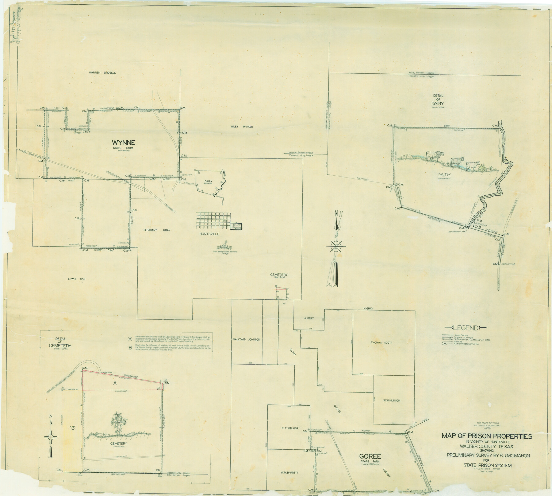
Map of Prison Properties in Vicinity of Huntsville, Walker County, Texas
-
Map/Doc
62992
-
Collection
General Map Collection
-
Object Dates
11/1933 (Creation Date)
-
People and Organizations
Lewis T. Smith (Compiler)
R.J. McMahon (Surveyor/Engineer)
-
Counties
Walker
-
Subjects
Prison Farms
-
Height x Width
36.6 x 43.0 inches
93.0 x 109.2 cm
-
Comments
Conservation funded in 2006 by Friends of the Texas General Land Office. Drawings at sites of dairy, Sam Houston, State Teachers College, and cemetery.
Part of: General Map Collection

Pecos County Sketch File 96

Print $40.00
- Digital $50.00
Pecos County Sketch File 96
1957
Size 22.4 x 8.7 inches
Map/Doc 33998
Pecos County Working Sketch 87

Print $20.00
- Digital $50.00
Pecos County Working Sketch 87
1962
Size 29.0 x 31.6 inches
Map/Doc 71559
Matagorda Bay Including Lavaca and Tres Palacios Bays

Print $20.00
- Digital $50.00
Matagorda Bay Including Lavaca and Tres Palacios Bays
1975
Size 37.2 x 47.7 inches
Map/Doc 73364
Edwards County Sketch File 34

Print $20.00
- Digital $50.00
Edwards County Sketch File 34
Size 16.8 x 19.0 inches
Map/Doc 11434
Rio Grande Rectification Project, El Paso and Juarez Valley

Print $3.00
- Digital $50.00
Rio Grande Rectification Project, El Paso and Juarez Valley
1935
Size 9.7 x 14.9 inches
Map/Doc 1749
[San Antonio & Galveston RR]
![64149, [San Antonio & Galveston RR], General Map Collection](https://historictexasmaps.com/wmedia_w700/maps/64149.tif.jpg)
Print $20.00
- Digital $50.00
[San Antonio & Galveston RR]
Size 37.6 x 11.2 inches
Map/Doc 64149
Cameron County

Print $20.00
- Digital $50.00
Cameron County
1976
Size 30.9 x 38.1 inches
Map/Doc 77230
Goliad County Working Sketch 13

Print $20.00
- Digital $50.00
Goliad County Working Sketch 13
1943
Size 28.3 x 40.8 inches
Map/Doc 63203
Presidio County Rolled Sketch 50

Print $20.00
- Digital $50.00
Presidio County Rolled Sketch 50
Size 21.2 x 18.4 inches
Map/Doc 7344
Mason County Working Sketch Graphic Index

Print $20.00
- Digital $50.00
Mason County Working Sketch Graphic Index
1980
Size 46.4 x 35.7 inches
Map/Doc 76632
Live Oak County Working Sketch 10

Print $20.00
- Digital $50.00
Live Oak County Working Sketch 10
1946
Size 36.2 x 41.8 inches
Map/Doc 70595
You may also like
Controlled Mosaic by Jack Amman Photogrammetric Engineers, Inc - Sheet 4

Print $20.00
- Digital $50.00
Controlled Mosaic by Jack Amman Photogrammetric Engineers, Inc - Sheet 4
1954
Size 20.0 x 24.0 inches
Map/Doc 83448
Montgomery County Sketch File 18

Print $20.00
- Digital $50.00
Montgomery County Sketch File 18
1899
Size 22.1 x 19.6 inches
Map/Doc 42122
[Map of Henderson County]
![76767, [Map of Henderson County], General Map Collection](https://historictexasmaps.com/wmedia_w700/maps/76767.tif.jpg)
Print $20.00
- Digital $50.00
[Map of Henderson County]
1854
Size 29.7 x 22.0 inches
Map/Doc 76767
Map showing lands surveyed by Sylvan Sanders in the Southwestern Part of Jack County, Texas for Buttram Petroleum Corporation

Print $20.00
- Digital $50.00
Map showing lands surveyed by Sylvan Sanders in the Southwestern Part of Jack County, Texas for Buttram Petroleum Corporation
Size 21.2 x 12.9 inches
Map/Doc 92186
[Surveys in Austin's Colony along the west bank of the Colorado River]
![199, [Surveys in Austin's Colony along the west bank of the Colorado River], General Map Collection](https://historictexasmaps.com/wmedia_w700/maps/199.tif.jpg)
Print $20.00
- Digital $50.00
[Surveys in Austin's Colony along the west bank of the Colorado River]
1831
Size 10.9 x 28.5 inches
Map/Doc 199
[East Part of Bailey County and West Part of Lamb County]
![91048, [East Part of Bailey County and West Part of Lamb County], Twichell Survey Records](https://historictexasmaps.com/wmedia_w700/maps/91048-1.tif.jpg)
Print $20.00
- Digital $50.00
[East Part of Bailey County and West Part of Lamb County]
Size 22.5 x 18.3 inches
Map/Doc 91048
King County Boundary File 3

Print $54.00
- Digital $50.00
King County Boundary File 3
Size 14.1 x 8.5 inches
Map/Doc 64896
Val Verde County Sketch File 45

Print $20.00
- Digital $50.00
Val Verde County Sketch File 45
1938
Size 21.3 x 16.5 inches
Map/Doc 12586
University Land Field Notes for Blocks A, B, C, D, E, F, G, H, I, and J in Hudspeth County

University Land Field Notes for Blocks A, B, C, D, E, F, G, H, I, and J in Hudspeth County
Map/Doc 81712
[Capitol Leagues 572 & 573, T. A. Thomson Blk. T4, part of D. S. & E. Blk. O4]
![90402, [Capitol Leagues 572 & 573, T. A. Thomson Blk. T4, part of D. S. & E. Blk. O4], Twichell Survey Records](https://historictexasmaps.com/wmedia_w700/maps/90402-1.tif.jpg)
Print $20.00
- Digital $50.00
[Capitol Leagues 572 & 573, T. A. Thomson Blk. T4, part of D. S. & E. Blk. O4]
Size 21.8 x 16.7 inches
Map/Doc 90402
Bastrop County Boundary File 3

Print $48.00
- Digital $50.00
Bastrop County Boundary File 3
1925
Size 11.3 x 8.7 inches
Map/Doc 50320
Sutton County Rolled Sketch 54

Print $20.00
- Digital $50.00
Sutton County Rolled Sketch 54
Size 32.4 x 27.7 inches
Map/Doc 7894