King County Boundary File 3
-
Map/Doc
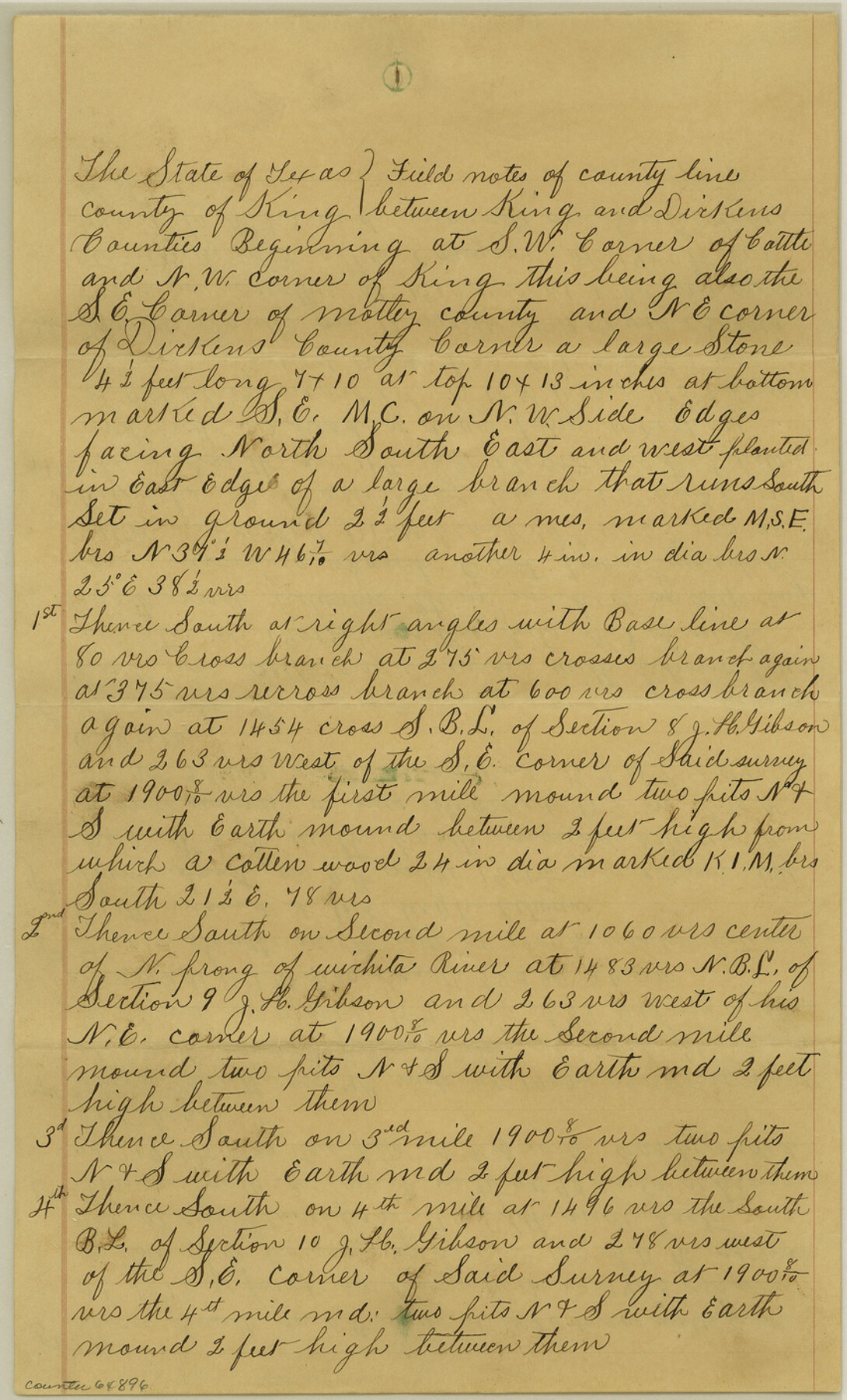
64896
-
Collection
General Map Collection
-
Counties
King
-
Subjects
County Boundaries
-
Height x Width
14.1 x 8.5 inches
35.8 x 21.6 cm
Part of: General Map Collection
Flight Mission No. DQO-2K, Frame 89, Galveston County

Print $20.00
- Digital $50.00
Flight Mission No. DQO-2K, Frame 89, Galveston County
1952
Size 18.6 x 22.3 inches
Map/Doc 85016
Montgomery County Sketch File 2a

Print $4.00
- Digital $50.00
Montgomery County Sketch File 2a
1849
Size 8.0 x 12.3 inches
Map/Doc 31768
Real County Rolled Sketch 10

Print $20.00
- Digital $50.00
Real County Rolled Sketch 10
Size 43.7 x 34.3 inches
Map/Doc 9835
Texas-Oklahoma Paris Quadrangle

Print $20.00
- Digital $50.00
Texas-Oklahoma Paris Quadrangle
Size 22.3 x 18.4 inches
Map/Doc 75107
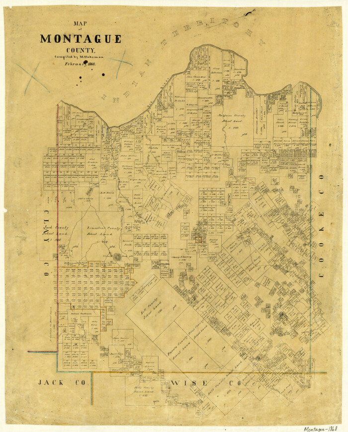
Map of Montague County
Print $20.00
- Digital $50.00
Map of Montague County
1868
Size 24.1 x 19.7 inches
Map/Doc 3887
Tyler County Rolled Sketch 1

Print $20.00
- Digital $50.00
Tyler County Rolled Sketch 1
1941
Size 16.4 x 19.7 inches
Map/Doc 8055
Flight Mission No. BQR-20K, Frame 12, Brazoria County

Print $20.00
- Digital $50.00
Flight Mission No. BQR-20K, Frame 12, Brazoria County
1952
Size 18.6 x 22.4 inches
Map/Doc 84114
Kimble County Sketch File 18

Print $22.00
- Digital $50.00
Kimble County Sketch File 18
1890
Size 8.8 x 14.2 inches
Map/Doc 28953
Brazoria County Sketch File 14

Print $8.00
- Digital $50.00
Brazoria County Sketch File 14
1892
Size 13.9 x 8.7 inches
Map/Doc 14973
Lubbock County Working Sketch 8

Print $20.00
- Digital $50.00
Lubbock County Working Sketch 8
1989
Size 27.4 x 25.2 inches
Map/Doc 70668
Terrell County Rolled Sketch 39

Print $20.00
- Digital $50.00
Terrell County Rolled Sketch 39
1941
Size 18.7 x 42.9 inches
Map/Doc 7943
Cochran County Working Sketch 4

Print $20.00
- Digital $50.00
Cochran County Working Sketch 4
1984
Size 37.7 x 24.8 inches
Map/Doc 68015
You may also like
Gulf of Mexico

Print $20.00
- Digital $50.00
Gulf of Mexico
1908
Size 18.3 x 26.9 inches
Map/Doc 72655
Galveston Bay, Texas

Print $20.00
- Digital $50.00
Galveston Bay, Texas
1905
Size 22.1 x 18.5 inches
Map/Doc 65389
Jefferson County Sketch File 6

Print $4.00
- Digital $50.00
Jefferson County Sketch File 6
1860
Size 12.3 x 7.8 inches
Map/Doc 28110
Titus County Working Sketch 7

Print $20.00
- Digital $50.00
Titus County Working Sketch 7
1970
Size 31.5 x 28.7 inches
Map/Doc 69368
McCulloch County Working Sketch 5

Print $20.00
- Digital $50.00
McCulloch County Working Sketch 5
1961
Size 21.3 x 19.2 inches
Map/Doc 70680
Gregg County Sketch File 1G

Print $2.00
- Digital $50.00
Gregg County Sketch File 1G
Size 6.2 x 7.0 inches
Map/Doc 24549
Presidio County Rolled Sketch 85

Print $20.00
- Digital $50.00
Presidio County Rolled Sketch 85
1930
Size 28.3 x 27.3 inches
Map/Doc 7371
Map No. 1 - Rio Bravo del Norte section of boundary between the United States & Mexico agreed upon by the Joint Commission under the Treaty of Guadalupe Hidalgo

Print $20.00
- Digital $50.00
Map No. 1 - Rio Bravo del Norte section of boundary between the United States & Mexico agreed upon by the Joint Commission under the Treaty of Guadalupe Hidalgo
1852
Size 18.4 x 27.0 inches
Map/Doc 72866
Gaines County Working Sketch 34

Print $20.00
- Digital $50.00
Gaines County Working Sketch 34
1990
Size 21.0 x 20.2 inches
Map/Doc 69334
Harbor Pass and Bar at Brazos Santiago, Texas

Print $20.00
- Digital $50.00
Harbor Pass and Bar at Brazos Santiago, Texas
1871
Size 18.2 x 26.8 inches
Map/Doc 72983

Johnson County Working Sketch 20

Print $20.00
- Digital $50.00
Johnson County Working Sketch 20
1991
Size 23.4 x 29.0 inches
Map/Doc 66633