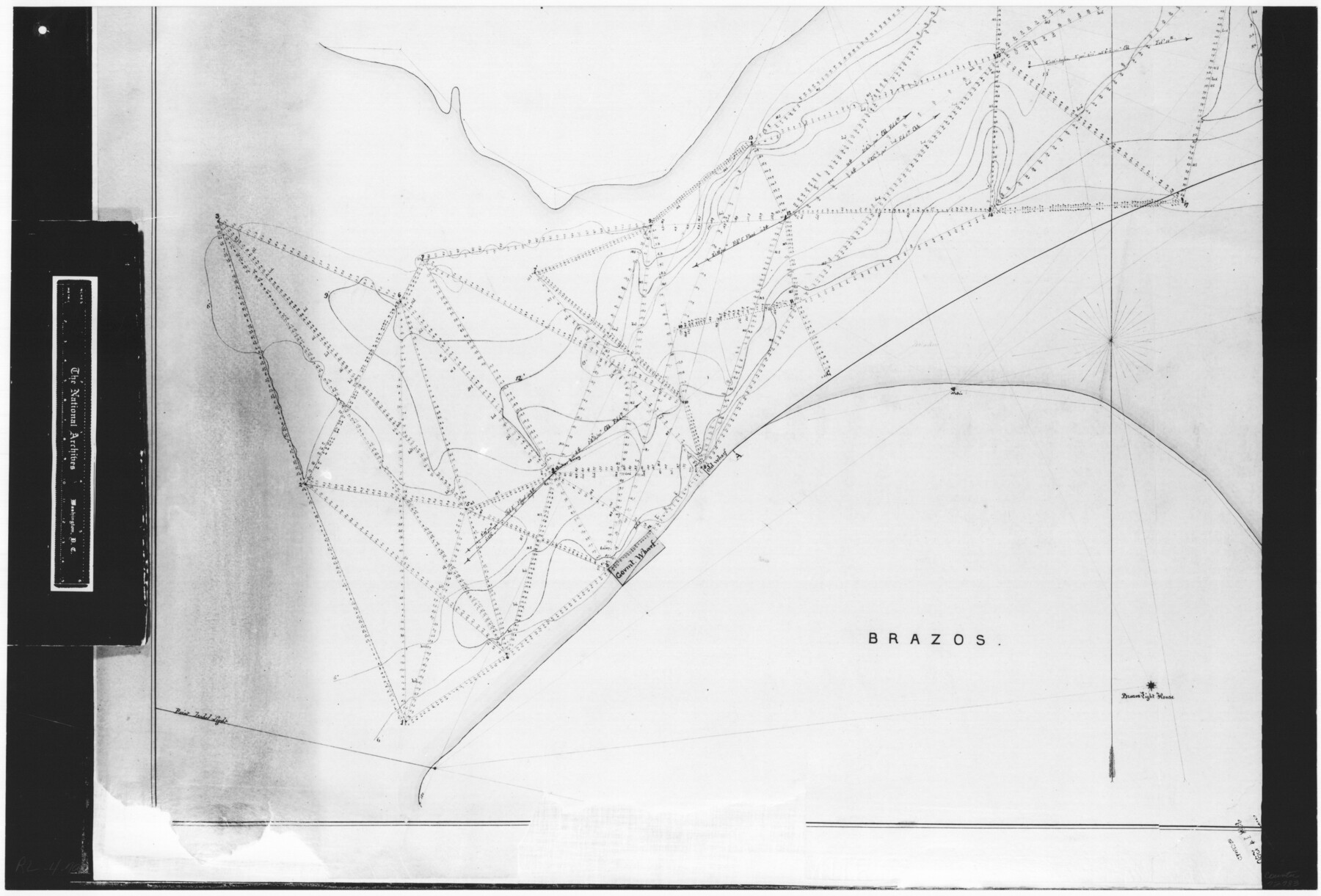
Harbor Pass and Bar at Brazos Santiago, Texas
RL-4-7a
-
Map/Doc
72983
-
Collection
General Map Collection
-
Object Dates
1871/2/10 (Creation Date)
-
People and Organizations
U. S. Army Engineers (Author)
H.M. Adams (Surveyor/Engineer)
-
Subjects
Nautical Charts
-
Height x Width
18.2 x 26.8 inches
46.2 x 68.1 cm
-
Comments
B/W photostat copy from National Archives in multiple pieces.
Part of: General Map Collection
Corpus Christi Bay

Print $20.00
- Digital $50.00
Corpus Christi Bay
1973
Size 36.6 x 47.7 inches
Map/Doc 73474
Kaufman County Sketch File 2

Print $6.00
- Digital $50.00
Kaufman County Sketch File 2
Size 8.7 x 10.3 inches
Map/Doc 28626
Caldwell County Sketch File 4

Print $8.00
- Digital $50.00
Caldwell County Sketch File 4
Size 8.8 x 6.9 inches
Map/Doc 35831
Hunt County Rolled Sketch 4

Print $209.00
- Digital $50.00
Hunt County Rolled Sketch 4
1959
Size 10.4 x 15.2 inches
Map/Doc 45992
Gray County Sketch File 7c

Print $20.00
- Digital $50.00
Gray County Sketch File 7c
1885
Size 26.5 x 19.6 inches
Map/Doc 11576
Flight Mission No. DQN-6K, Frame 13, Calhoun County

Print $20.00
- Digital $50.00
Flight Mission No. DQN-6K, Frame 13, Calhoun County
1953
Size 18.5 x 22.2 inches
Map/Doc 84435
Zavala County Sketch File 42

Print $20.00
- Digital $50.00
Zavala County Sketch File 42
1915
Size 19.4 x 25.6 inches
Map/Doc 12732
Burleson County Working Sketch 25

Print $20.00
- Digital $50.00
Burleson County Working Sketch 25
1981
Size 27.9 x 31.0 inches
Map/Doc 67744
Flight Mission No. DAG-23K, Frame 152, Matagorda County

Print $20.00
- Digital $50.00
Flight Mission No. DAG-23K, Frame 152, Matagorda County
1953
Size 15.9 x 15.9 inches
Map/Doc 86500
Karnes County Working Sketch 4

Print $20.00
- Digital $50.00
Karnes County Working Sketch 4
1960
Size 29.3 x 38.8 inches
Map/Doc 66652
Liberty County Working Sketch 7

Print $20.00
- Digital $50.00
Liberty County Working Sketch 7
1906
Size 22.2 x 24.8 inches
Map/Doc 70466
Hudspeth County Sketch File 38

Print $20.00
- Digital $50.00
Hudspeth County Sketch File 38
Size 27.5 x 24.1 inches
Map/Doc 11806
You may also like
Map of the District of San Patricio and Nueces

Print $40.00
- Digital $50.00
Map of the District of San Patricio and Nueces
Size 93.9 x 36.4 inches
Map/Doc 93367
Flight Mission No. BQR-3K, Frame 162, Brazoria County

Print $20.00
- Digital $50.00
Flight Mission No. BQR-3K, Frame 162, Brazoria County
1952
Size 18.7 x 22.4 inches
Map/Doc 83989
General Highway Map, Sabine County, Texas

Print $20.00
General Highway Map, Sabine County, Texas
1961
Size 24.6 x 18.1 inches
Map/Doc 79644
Houston Ship Channel, Alexander Island to Carpenter Bayou

Print $40.00
- Digital $50.00
Houston Ship Channel, Alexander Island to Carpenter Bayou
1989
Size 35.5 x 49.4 inches
Map/Doc 69916
Map of DeWitt County

Print $20.00
- Digital $50.00
Map of DeWitt County
1881
Size 21.7 x 24.3 inches
Map/Doc 3478
Dawson County

Print $20.00
- Digital $50.00
Dawson County
1959
Size 43.5 x 35.1 inches
Map/Doc 77259
Travis County Rolled Sketch 61

Print $20.00
- Digital $50.00
Travis County Rolled Sketch 61
2023
Size 36.0 x 24.0 inches
Map/Doc 97184
Sabine Pass and Lake

Print $20.00
- Digital $50.00
Sabine Pass and Lake
1961
Size 46.7 x 28.1 inches
Map/Doc 69824
Revised Map of Austin, Texas

Print $20.00
Revised Map of Austin, Texas
1885
Size 16.5 x 14.0 inches
Map/Doc 76272
Hardeman County Sketch File 3

Print $8.00
- Digital $50.00
Hardeman County Sketch File 3
1880
Size 14.2 x 8.8 inches
Map/Doc 24987
Goliad County Rolled Sketch 5

Print $20.00
- Digital $50.00
Goliad County Rolled Sketch 5
1956
Size 26.5 x 29.5 inches
Map/Doc 6025
Zavala County

Print $20.00
- Digital $50.00
Zavala County
1915
Size 38.6 x 46.6 inches
Map/Doc 16940