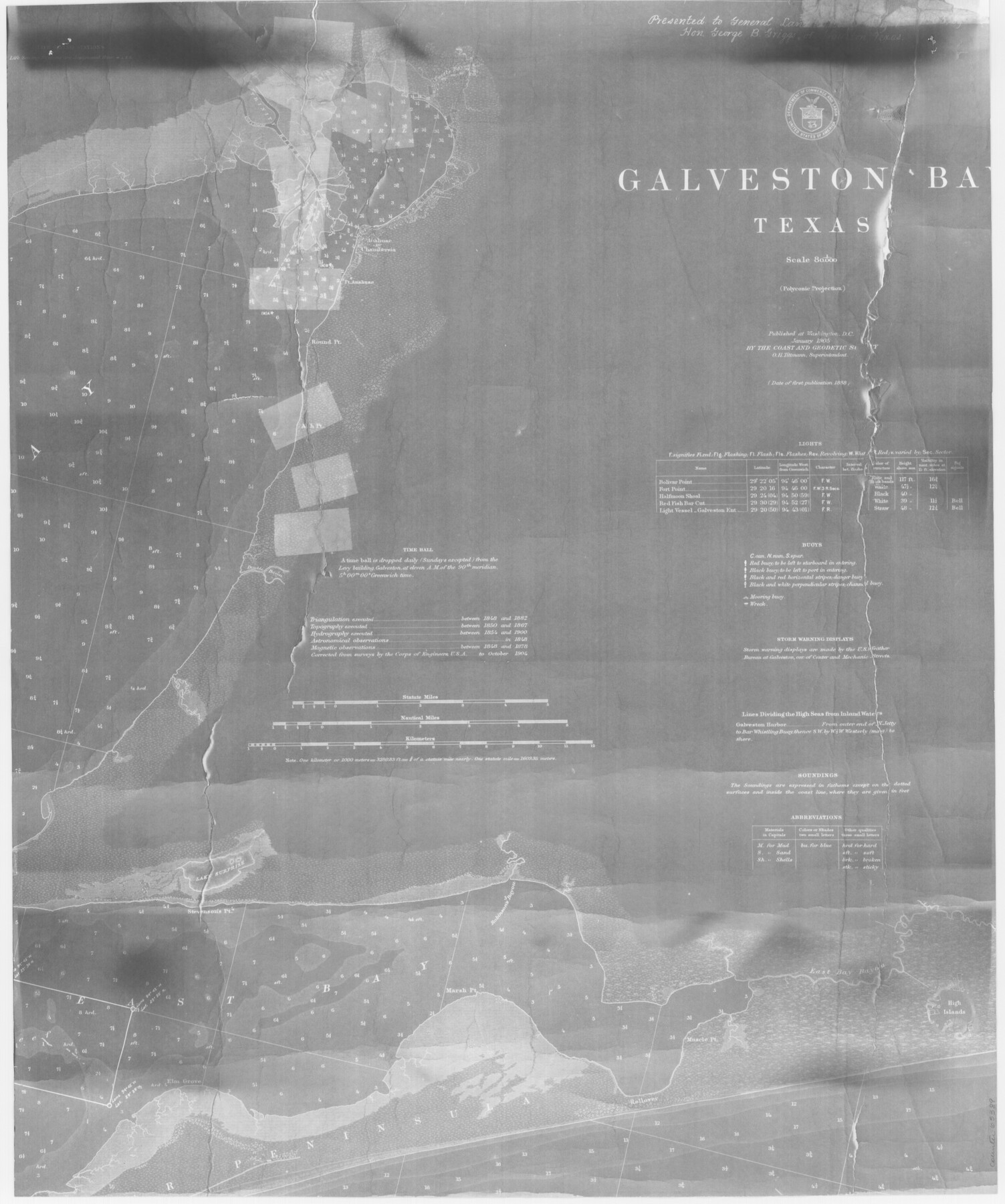
Galveston Bay, Texas
K-7-66
-
Map/Doc
65389
-
Collection
General Map Collection
-
Object Dates
1905 (Creation Date)
-
People and Organizations
Coast and Geodetic Survey (Publisher)
-
Counties
Chambers Galveston
-
Subjects
Nautical Charts
-
Height x Width
22.1 x 18.5 inches
56.1 x 47.0 cm
Part of: General Map Collection
Reeves County Rolled Sketch 1

Print $40.00
- Digital $50.00
Reeves County Rolled Sketch 1
Size 52.9 x 38.5 inches
Map/Doc 9844

Harrison County Rolled Sketch 10

Print $20.00
- Digital $50.00
Harrison County Rolled Sketch 10
1956
Size 33.6 x 26.1 inches
Map/Doc 6153
Young County Working Sketch 24

Print $20.00
- Digital $50.00
Young County Working Sketch 24
1977
Size 25.7 x 16.3 inches
Map/Doc 62047
Hunt County Working Sketch 9

Print $20.00
- Digital $50.00
Hunt County Working Sketch 9
1959
Size 33.8 x 30.6 inches
Map/Doc 66356
Calhoun County Rolled Sketch 26

Print $20.00
- Digital $50.00
Calhoun County Rolled Sketch 26
1941
Size 10.9 x 39.9 inches
Map/Doc 5374
Flight Mission No. BRA-6M, Frame 150, Jefferson County

Print $20.00
- Digital $50.00
Flight Mission No. BRA-6M, Frame 150, Jefferson County
1953
Size 18.5 x 22.4 inches
Map/Doc 85451
Kimble County Working Sketch 1

Print $20.00
- Digital $50.00
Kimble County Working Sketch 1
Size 14.7 x 18.3 inches
Map/Doc 70069
Jefferson County Rolled Sketch 46

Print $2.00
- Digital $50.00
Jefferson County Rolled Sketch 46
1969
Size 12.3 x 5.9 inches
Map/Doc 10198
A new map for travellers through the United States of America showing the railroads, canals & stageroads with the distances

Print $20.00
- Digital $50.00
A new map for travellers through the United States of America showing the railroads, canals & stageroads with the distances
1846
Size 22.4 x 27.9 inches
Map/Doc 95921
Borden County Sketch File 10a

Print $40.00
- Digital $50.00
Borden County Sketch File 10a
Size 21.0 x 37.5 inches
Map/Doc 10935
Map of Panola County

Print $20.00
- Digital $50.00
Map of Panola County
1863
Size 19.6 x 19.3 inches
Map/Doc 4503
You may also like
Shelby County Sketch File 28

Print $4.00
- Digital $50.00
Shelby County Sketch File 28
Size 6.2 x 7.9 inches
Map/Doc 36664
PSL Field Notes for Blocks C1, C2, and C3 in Pecos and Reeves Counties and Blocks C4 through C10 in Reeves County

PSL Field Notes for Blocks C1, C2, and C3 in Pecos and Reeves Counties and Blocks C4 through C10 in Reeves County
Map/Doc 81671
Flight Mission No. BRE-2P, Frame 63, Nueces County

Print $20.00
- Digital $50.00
Flight Mission No. BRE-2P, Frame 63, Nueces County
1956
Size 18.5 x 22.5 inches
Map/Doc 86758
[J. B. Sneed, S. Robinson, and vicinity]
![91041, [J. B. Sneed, S. Robinson, and vicinity], Twichell Survey Records](https://historictexasmaps.com/wmedia_w700/maps/91041-1.tif.jpg)
Print $20.00
- Digital $50.00
[J. B. Sneed, S. Robinson, and vicinity]
Size 32.4 x 12.8 inches
Map/Doc 91041
Wichita County Working Sketch 3

Print $20.00
- Digital $50.00
Wichita County Working Sketch 3
1913
Size 22.2 x 15.6 inches
Map/Doc 72512
A New Map of Texas, Oregon and California with the Regions adjoining

Print $20.00
- Digital $50.00
A New Map of Texas, Oregon and California with the Regions adjoining
1846
Size 20.4 x 19.3 inches
Map/Doc 89067
Morris County Rolled Sketch 2A

Print $20.00
- Digital $50.00
Morris County Rolled Sketch 2A
Size 13.3 x 19.0 inches
Map/Doc 10232
Kimble County Working Sketch 79

Print $20.00
- Digital $50.00
Kimble County Working Sketch 79
1971
Size 34.7 x 31.9 inches
Map/Doc 70147

[Block V and surrounding surveys]
![90292, [Block V and surrounding surveys], Twichell Survey Records](https://historictexasmaps.com/wmedia_w700/maps/90292-1.tif.jpg)
Print $3.00
- Digital $50.00
[Block V and surrounding surveys]
Size 11.9 x 12.5 inches
Map/Doc 90292
Webb County Working Sketch 72

Print $20.00
- Digital $50.00
Webb County Working Sketch 72
1974
Size 22.1 x 38.2 inches
Map/Doc 72439
Map of Bell County

Print $40.00
- Digital $50.00
Map of Bell County
1896
Size 49.0 x 53.5 inches
Map/Doc 4768