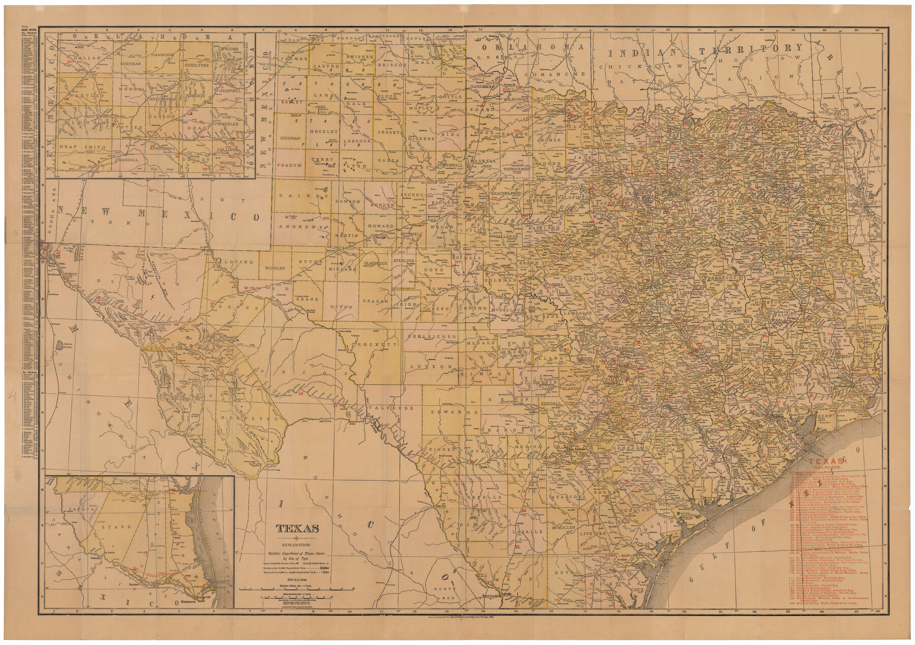
Texas
[Inset 1: Panhandle] / [Inset 2: Southern Portion of Texas]
-
Map/Doc
95845
-
Collection
Cobb Digital Map Collection
-
Object Dates
1905 (Creation Date)
-
People and Organizations
Rand, McNally & Co. (Publisher)
-
Subjects
Railroads State of Texas
-
Height x Width
28.4 x 40.2 inches
72.1 x 102.1 cm
-
Medium
digital image
-
Scale
1" = 20 statute miles
-
Comments
Courtesy of John & Diana Cobb.
To view full booklet in which this map was contained, click "Download PDF" link above.
Part of: Cobb Digital Map Collection
Missouri, Kansas, & Texas Ry.

Print $20.00
- Digital $50.00
Missouri, Kansas, & Texas Ry.
Size 6.7 x 5.4 inches
Map/Doc 96598
A Few Things About Rice as grown along the line of the Sunset Route in Louisiana and Texas

A Few Things About Rice as grown along the line of the Sunset Route in Louisiana and Texas
1904
Map/Doc 96724
Mileage Map of the Transcontinental Trails of the United States showing best roads, road distances, principal cities

Print $20.00
- Digital $50.00
Mileage Map of the Transcontinental Trails of the United States showing best roads, road distances, principal cities
1920
Size 10.8 x 12.8 inches
Map/Doc 95899
Due Southwest over the Cotton Belt Route

Due Southwest over the Cotton Belt Route
1891
Map/Doc 96773
Map of the Texas and Pacific Railway and connections

Print $20.00
- Digital $50.00
Map of the Texas and Pacific Railway and connections
1925
Size 8.2 x 9.3 inches
Map/Doc 95772

Geographically Correct Map of United States showing the Union Pacific System - Union Pacific R.R. Co., Oregon Short Line R.R. Co., Oregon-Washington R.R. & Nav. Co., Los Angeles & Salt Lake R.R. Co., St. Joseph & Grand Island Ry. Co. and connections

Print $20.00
- Digital $50.00
Geographically Correct Map of United States showing the Union Pacific System - Union Pacific R.R. Co., Oregon Short Line R.R. Co., Oregon-Washington R.R. & Nav. Co., Los Angeles & Salt Lake R.R. Co., St. Joseph & Grand Island Ry. Co. and connections
1922
Size 18.2 x 32.2 inches
Map/Doc 95771
Texas: Her Resources and Capabilities: being a description of the State of Texas and the inducements She offers to those seeking homes in a new country

Texas: Her Resources and Capabilities: being a description of the State of Texas and the inducements She offers to those seeking homes in a new country
1881
Size 9.3 x 6.1 inches
Map/Doc 96615
Tourists' Handbook Descriptive of Colorado, New Mexico and Utah

Tourists' Handbook Descriptive of Colorado, New Mexico and Utah
1898
Size 9.4 x 6.4 inches
Map/Doc 97075
Sectional map of Texas traversed by the Missouri, Kansas & Texas Railway, showing the crops adapted to each section, with the elevation and annual rainfall

Print $20.00
- Digital $50.00
Sectional map of Texas traversed by the Missouri, Kansas & Texas Railway, showing the crops adapted to each section, with the elevation and annual rainfall
1904
Size 21.9 x 23.0 inches
Map/Doc 95815
Corpus Christi, Where Texas Meets the Sea

Corpus Christi, Where Texas Meets the Sea
1927
Size 9.6 x 4.3 inches
Map/Doc 97064

You may also like
Il Disegno del discoperto della nova Franza, il quale se havuto ultimamente dalla novissima navigatione dè Francesi in quel luogo

Print $20.00
- Digital $50.00
Il Disegno del discoperto della nova Franza, il quale se havuto ultimamente dalla novissima navigatione dè Francesi in quel luogo
1566
Size 12.6 x 18.6 inches
Map/Doc 93804
Trinity County Sketch File 5b

Print $4.00
- Digital $50.00
Trinity County Sketch File 5b
1855
Size 12.6 x 8.0 inches
Map/Doc 38506
Cooke County Sketch File 20

Print $22.00
- Digital $50.00
Cooke County Sketch File 20
1862
Size 9.1 x 6.9 inches
Map/Doc 19264
[Surveys in Austin's Colony along the Brazos River and Oyster Creek]
![206, [Surveys in Austin's Colony along the Brazos River and Oyster Creek], General Map Collection](https://historictexasmaps.com/wmedia_w700/maps/206.tif.jpg)
Print $20.00
- Digital $50.00
[Surveys in Austin's Colony along the Brazos River and Oyster Creek]
1824
Size 23.1 x 17.2 inches
Map/Doc 206
Wood County Sketch File 5a

Print $4.00
- Digital $50.00
Wood County Sketch File 5a
1857
Size 10.1 x 8.0 inches
Map/Doc 40639
Gillespie County Sketch File 14

Print $6.00
- Digital $50.00
Gillespie County Sketch File 14
1880
Size 10.1 x 11.4 inches
Map/Doc 24155
Texas City Channel, Texas, Channel and Turning Basin Dredging - Sheet 3

Print $20.00
- Digital $50.00
Texas City Channel, Texas, Channel and Turning Basin Dredging - Sheet 3
1958
Size 28.4 x 40.6 inches
Map/Doc 61833
[Right of Way & Track Map, The Texas & Pacific Ry. Co. Main Line]
![64670, [Right of Way & Track Map, The Texas & Pacific Ry. Co. Main Line], General Map Collection](https://historictexasmaps.com/wmedia_w700/maps/64670.tif.jpg)
Print $20.00
- Digital $50.00
[Right of Way & Track Map, The Texas & Pacific Ry. Co. Main Line]
Size 11.0 x 18.5 inches
Map/Doc 64670
Hood County Sketch File 24

Print $8.00
- Digital $50.00
Hood County Sketch File 24
1942
Size 11.0 x 9.0 inches
Map/Doc 26619
Brazoria County Working Sketch 49b

Print $20.00
- Digital $50.00
Brazoria County Working Sketch 49b
2003
Size 34.9 x 35.3 inches
Map/Doc 78348
Scarborough's Topographic Map of Massachusetts showing railroads, electric railways, steamboat lines, highways, post offices, villages, etc. completely indexed

Print $40.00
- Digital $50.00
Scarborough's Topographic Map of Massachusetts showing railroads, electric railways, steamboat lines, highways, post offices, villages, etc. completely indexed
1903
Size 39.8 x 59.4 inches
Map/Doc 97107
Flight Mission No. BRE-1P, Frame 10, Nueces County

Print $20.00
- Digital $50.00
Flight Mission No. BRE-1P, Frame 10, Nueces County
1956
Size 18.4 x 22.5 inches
Map/Doc 86618