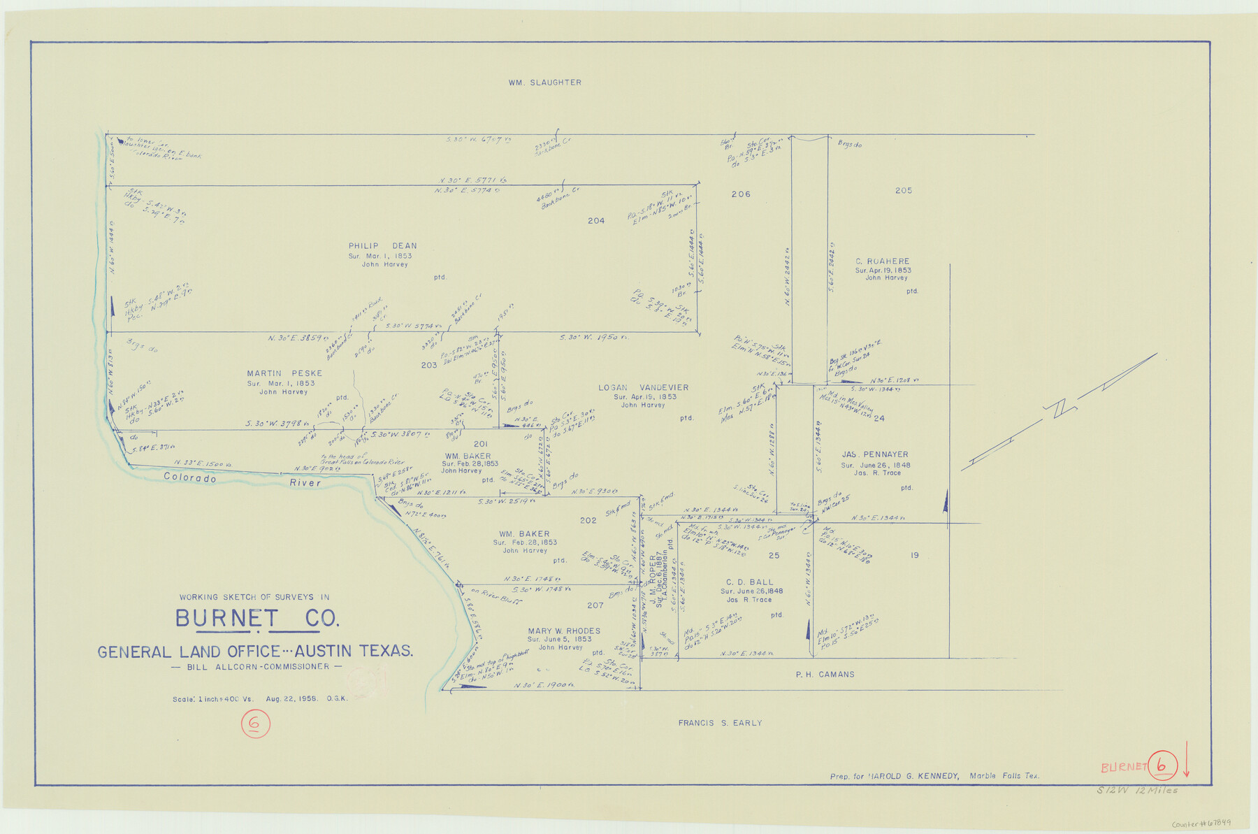
Burnet County Working Sketch 6
-
Map/Doc
67849
-
Collection
General Map Collection
-
Object Dates
8/22/1958 (Creation Date)
-
People and Organizations
Otto G. Kurio (Draftsman)
-
Counties
Burnet
-
Subjects
Surveying Working Sketch
-
Height x Width
20.5 x 31.0 inches
52.1 x 78.7 cm
-
Scale
1" = 400 varas
Part of: General Map Collection
Flight Mission No. CGI-3N, Frame 69, Cameron County

Print $20.00
- Digital $50.00
Flight Mission No. CGI-3N, Frame 69, Cameron County
1954
Size 18.4 x 22.1 inches
Map/Doc 84563
Shelby County Sketch File 4

Print $4.00
- Digital $50.00
Shelby County Sketch File 4
1852
Size 13.1 x 8.2 inches
Map/Doc 36597
Nacogdoches County Sketch File 20

Print $26.00
- Digital $50.00
Nacogdoches County Sketch File 20
Size 12.6 x 7.9 inches
Map/Doc 32275
Flight Mission No. BRE-3P, Frame 96, Nueces County

Print $20.00
- Digital $50.00
Flight Mission No. BRE-3P, Frame 96, Nueces County
1956
Size 18.3 x 22.2 inches
Map/Doc 86827
United States Bathymetric and Fishing Maps including Topographic/Bathymetric Maps

Print $40.00
- Digital $50.00
United States Bathymetric and Fishing Maps including Topographic/Bathymetric Maps
1989
Size 20.4 x 54.4 inches
Map/Doc 73557
Johnson County

Print $20.00
- Digital $50.00
Johnson County
1943
Size 42.4 x 39.0 inches
Map/Doc 1868
Palo Pinto County Rolled Sketch 5

Print $40.00
- Digital $50.00
Palo Pinto County Rolled Sketch 5
Size 54.4 x 36.0 inches
Map/Doc 76021
Flight Mission No. BRA-7M, Frame 21, Jefferson County

Print $20.00
- Digital $50.00
Flight Mission No. BRA-7M, Frame 21, Jefferson County
1953
Size 18.4 x 22.2 inches
Map/Doc 85472
Map of Granbury

Print $20.00
- Digital $50.00
Map of Granbury
1960
Size 23.5 x 26.7 inches
Map/Doc 3041
Edwards County Working Sketch 1

Print $20.00
- Digital $50.00
Edwards County Working Sketch 1
Size 12.2 x 16.4 inches
Map/Doc 68877
Jackson County Sketch File 29

Print $10.00
- Digital $50.00
Jackson County Sketch File 29
Size 13.4 x 8.7 inches
Map/Doc 27725
Texas-Oklahoma Clara Quadrangle

Print $20.00
- Digital $50.00
Texas-Oklahoma Clara Quadrangle
1937
Size 20.3 x 16.9 inches
Map/Doc 75105
You may also like
Burnet County Working Sketch 2

Print $20.00
- Digital $50.00
Burnet County Working Sketch 2
1953
Size 18.3 x 29.1 inches
Map/Doc 67845
La Salle County Rolled Sketch 32

Print $20.00
- Digital $50.00
La Salle County Rolled Sketch 32
2012
Size 24.0 x 36.0 inches
Map/Doc 93286
San Patricio County Rolled Sketch 4

Print $20.00
- Digital $50.00
San Patricio County Rolled Sketch 4
1875
Size 18.4 x 28.8 inches
Map/Doc 7572
Hardin County Rolled Sketch 12

Print $20.00
- Digital $50.00
Hardin County Rolled Sketch 12
1949
Size 36.3 x 47.3 inches
Map/Doc 10200
Medina County Rolled Sketch 19

Print $40.00
- Digital $50.00
Medina County Rolled Sketch 19
1987
Size 45.1 x 57.8 inches
Map/Doc 9508
Galveston County Rolled Sketch RB

Print $20.00
- Digital $50.00
Galveston County Rolled Sketch RB
Size 36.0 x 22.2 inches
Map/Doc 5990
[Sketch showing Blocks C-11, C-13, C-14, C-16, C-10]
![93123, [Sketch showing Blocks C-11, C-13, C-14, C-16, C-10], Twichell Survey Records](https://historictexasmaps.com/wmedia_w700/maps/93123-1.tif.jpg)
Print $40.00
- Digital $50.00
[Sketch showing Blocks C-11, C-13, C-14, C-16, C-10]
Size 69.9 x 22.5 inches
Map/Doc 93123
Map of The Surveyed Part of Peters Colony Texas

Print $40.00
- Digital $50.00
Map of The Surveyed Part of Peters Colony Texas
1852
Size 54.0 x 28.8 inches
Map/Doc 3155
Fisher County

Print $40.00
- Digital $50.00
Fisher County
1944
Size 50.2 x 44.2 inches
Map/Doc 95497
Jeff Davis County Working Sketch Graphic Index - east part

Print $20.00
- Digital $50.00
Jeff Davis County Working Sketch Graphic Index - east part
1977
Size 46.6 x 36.8 inches
Map/Doc 76592
Calhoun County Rolled Sketch 30

Print $20.00
- Digital $50.00
Calhoun County Rolled Sketch 30
1974
Size 18.6 x 27.6 inches
Map/Doc 5495
McCulloch County Working Sketch 1

Print $20.00
- Digital $50.00
McCulloch County Working Sketch 1
1944
Size 29.8 x 29.9 inches
Map/Doc 70676