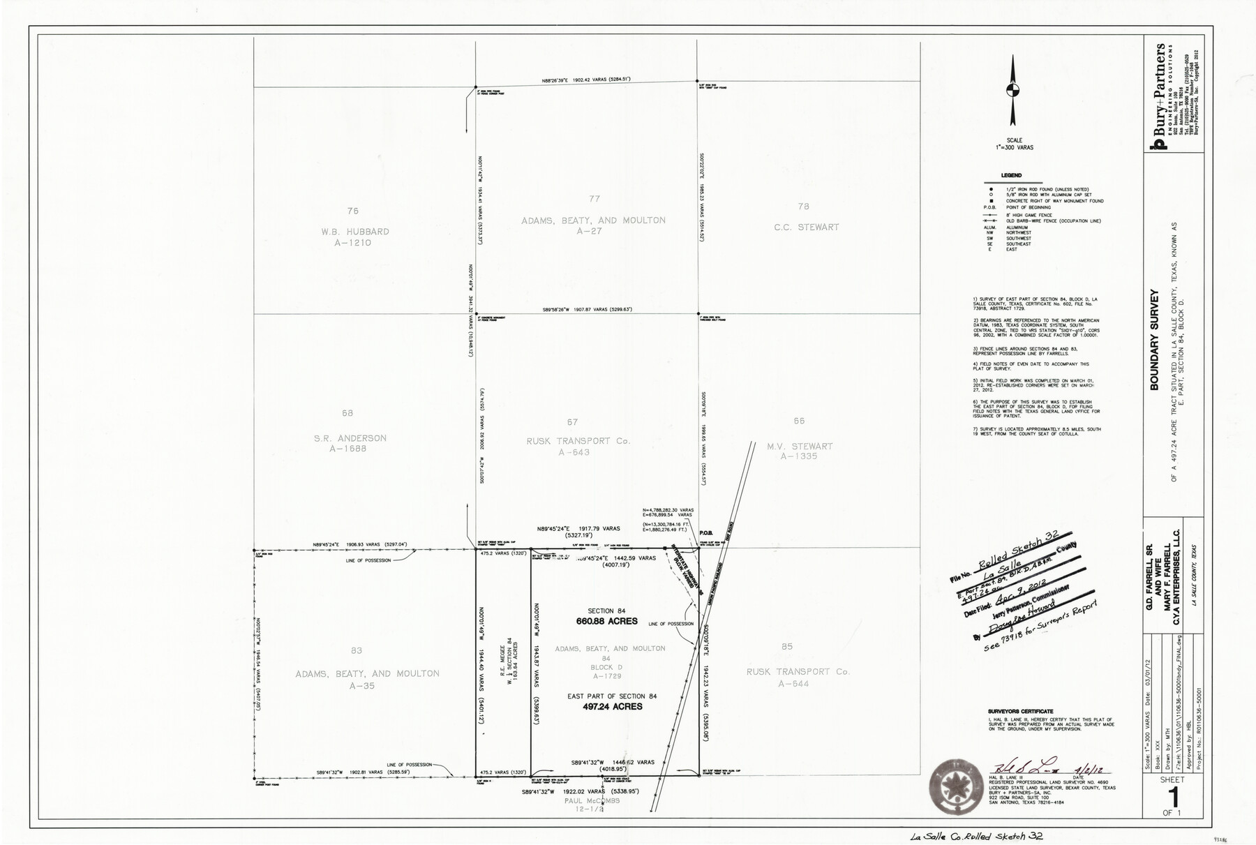
La Salle County Rolled Sketch 32
Boundary survey of a 497.24 acre tract situated in La Salle County Texas known as E. part, section 84, Block D
-
Map/Doc
93286
-
Collection
General Map Collection
-
Object Dates
4/2/2012 (Creation Date)
4/9/2012 (File Date)
-
People and Organizations
Hal B. Lane, III (Surveyor/Engineer)
-
Counties
La Salle
-
Subjects
Surveying Rolled Sketch
-
Height x Width
24.0 x 36.0 inches
61.0 x 91.4 cm
-
Medium
mylar, print
-
Scale
1" = 300 varas
-
Comments
See School File 73918 for report.
Part of: General Map Collection
Crane County Rolled Sketch 23

Print $20.00
- Digital $50.00
Crane County Rolled Sketch 23
2002
Size 23.9 x 34.3 inches
Map/Doc 76426
Brewster County Rolled Sketch 22B

Print $20.00
- Digital $50.00
Brewster County Rolled Sketch 22B
1910
Size 24.5 x 19.5 inches
Map/Doc 5203
El Paso County State Real Property Sketch 1

Print $20.00
- Digital $50.00
El Paso County State Real Property Sketch 1
2007
Size 24.1 x 36.2 inches
Map/Doc 88670
Controlled Mosaic by Jack Amman Photogrammetric Engineers, Inc - Sheet 37

Print $20.00
- Digital $50.00
Controlled Mosaic by Jack Amman Photogrammetric Engineers, Inc - Sheet 37
1954
Size 20.0 x 24.0 inches
Map/Doc 83492
Montgomery County Sketch File 6b

Print $40.00
- Digital $50.00
Montgomery County Sketch File 6b
Size 12.8 x 16.2 inches
Map/Doc 31783
Brazoria County NRC Article 33.136 Sketch 15

Print $44.00
- Digital $50.00
Brazoria County NRC Article 33.136 Sketch 15
2014
Size 39.8 x 30.0 inches
Map/Doc 94698
Terrell County Sketch File 17

Print $13.00
- Digital $50.00
Terrell County Sketch File 17
Size 10.1 x 8.1 inches
Map/Doc 37935
Map of a part of Laguna Madre showing subdivision for mineral development

Print $20.00
- Digital $50.00
Map of a part of Laguna Madre showing subdivision for mineral development
1948
Size 42.9 x 31.0 inches
Map/Doc 2913
Kerr County Sketch File 23

Print $8.00
- Digital $50.00
Kerr County Sketch File 23
1959
Size 14.2 x 8.8 inches
Map/Doc 28901
Houston Ship Channel

Print $20.00
- Digital $50.00
Houston Ship Channel
1926
Size 32.9 x 38.3 inches
Map/Doc 69893
Trinity County Sketch File 35a

Print $6.00
- Digital $50.00
Trinity County Sketch File 35a
1921
Size 16.8 x 8.8 inches
Map/Doc 38587
Flight Mission No. CRC-4R, Frame 150, Chambers County

Print $20.00
- Digital $50.00
Flight Mission No. CRC-4R, Frame 150, Chambers County
1956
Size 18.6 x 22.4 inches
Map/Doc 84913
You may also like
[Surveys in Polk and Chambers Counties]
![355, [Surveys in Polk and Chambers Counties], General Map Collection](https://historictexasmaps.com/wmedia_w700/maps/355.tif.jpg)
Print $3.00
- Digital $50.00
[Surveys in Polk and Chambers Counties]
Size 11.7 x 14.4 inches
Map/Doc 355
Taylor County Rolled Sketch 29

Print $20.00
- Digital $50.00
Taylor County Rolled Sketch 29
Size 20.2 x 24.2 inches
Map/Doc 7922
[G. & M. Block 5]
![91782, [G. & M. Block 5], Twichell Survey Records](https://historictexasmaps.com/wmedia_w700/maps/91782-1.tif.jpg)
Print $20.00
- Digital $50.00
[G. & M. Block 5]
Size 31.8 x 26.6 inches
Map/Doc 91782
Montgomery County Rolled Sketch 31

Print $20.00
- Digital $50.00
Montgomery County Rolled Sketch 31
1949
Size 43.6 x 42.2 inches
Map/Doc 9539
Jefferson County Rolled Sketch 25

Print $20.00
- Digital $50.00
Jefferson County Rolled Sketch 25
1939
Size 43.4 x 36.0 inches
Map/Doc 9290
Reagan County Working Sketch 25

Print $20.00
- Digital $50.00
Reagan County Working Sketch 25
1958
Size 45.8 x 42.8 inches
Map/Doc 71867
[Sketch showing Runnels County School Land survey and surrounding surveys]
![93112, [Sketch showing Runnels County School Land survey and surrounding surveys], Twichell Survey Records](https://historictexasmaps.com/wmedia_w700/maps/93112-1.tif.jpg)
Print $20.00
- Digital $50.00
[Sketch showing Runnels County School Land survey and surrounding surveys]
Size 21.4 x 14.3 inches
Map/Doc 93112
Tom Green County

Print $20.00
- Digital $50.00
Tom Green County
1942
Size 43.5 x 24.8 inches
Map/Doc 77437
Terry County Rolled Sketch 11

Print $20.00
- Digital $50.00
Terry County Rolled Sketch 11
2022
Size 37.1 x 25.1 inches
Map/Doc 97101
West Part of Edwards County

Print $20.00
- Digital $50.00
West Part of Edwards County
1975
Size 35.5 x 23.2 inches
Map/Doc 77271
Oldham County Working Sketch Graphic Index

Print $40.00
- Digital $50.00
Oldham County Working Sketch Graphic Index
1925
Size 42.2 x 51.7 inches
Map/Doc 76657
Medina County Working Sketch 11

Print $20.00
- Digital $50.00
Medina County Working Sketch 11
1963
Size 21.8 x 26.5 inches
Map/Doc 70926