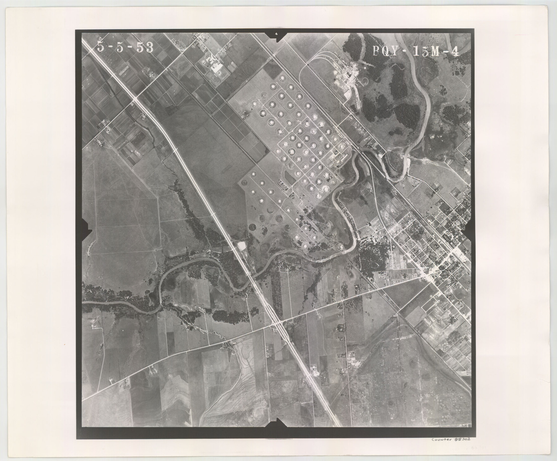
Flight Mission No. BQY-15M, Frame 4, Harris County
BQY-15M-4
-
Map/Doc
85302
-
Collection
General Map Collection
-
Object Dates
1953/5/5 (Creation Date)
-
People and Organizations
U. S. Department of Agriculture (Publisher)
-
Counties
Harris
-
Subjects
Aerial Photograph
-
Height x Width
18.6 x 22.4 inches
47.2 x 56.9 cm
-
Comments
Flown by Jack Ammann Photogrammetric Engineers of San Antonio, Texas.
Part of: General Map Collection
Goliad County Rolled Sketch 5

Print $20.00
- Digital $50.00
Goliad County Rolled Sketch 5
1956
Size 26.5 x 29.5 inches
Map/Doc 6025
Upton County Working Sketch 39

Print $20.00
- Digital $50.00
Upton County Working Sketch 39
1958
Size 25.4 x 30.1 inches
Map/Doc 69535
Cass County Working Sketch 36

Print $20.00
- Digital $50.00
Cass County Working Sketch 36
1982
Size 37.9 x 39.4 inches
Map/Doc 67939
Lamar County Sketch File 4

Print $50.00
- Digital $50.00
Lamar County Sketch File 4
Size 9.8 x 8.1 inches
Map/Doc 29278
Plat of a survey on Padre Island in Willacy and Kenedy Counties surveyed for South Padre Development Corporation by Claunch and Associates

Print $20.00
- Digital $50.00
Plat of a survey on Padre Island in Willacy and Kenedy Counties surveyed for South Padre Development Corporation by Claunch and Associates
1973
Size 46.5 x 41.6 inches
Map/Doc 61424
San Saba County Sketch File 19

Print $8.00
- Digital $50.00
San Saba County Sketch File 19
1873
Size 12.8 x 8.1 inches
Map/Doc 36466
Crockett County Working Sketch 57

Print $20.00
- Digital $50.00
Crockett County Working Sketch 57
1954
Size 35.9 x 38.8 inches
Map/Doc 68390
Brazoria County Working Sketch 9

Print $20.00
- Digital $50.00
Brazoria County Working Sketch 9
1934
Size 36.6 x 35.9 inches
Map/Doc 67494
Wise County Working Sketch 9

Print $20.00
- Digital $50.00
Wise County Working Sketch 9
1957
Size 23.6 x 29.0 inches
Map/Doc 72623
Kinney County Sketch File 23

Print $40.00
- Digital $50.00
Kinney County Sketch File 23
1901
Size 17.6 x 15.3 inches
Map/Doc 29162
Castro County Rolled Sketch 8

Print $20.00
- Digital $50.00
Castro County Rolled Sketch 8
Size 34.1 x 28.8 inches
Map/Doc 5418
Midland County Working Sketch 27

Print $20.00
- Digital $50.00
Midland County Working Sketch 27
1963
Size 41.6 x 38.9 inches
Map/Doc 71008
You may also like
Crosby County Sketch File 36

Print $4.00
- Digital $50.00
Crosby County Sketch File 36
1935
Size 7.5 x 9.2 inches
Map/Doc 20108
Pecos County Working Sketch 19

Print $20.00
- Digital $50.00
Pecos County Working Sketch 19
1917
Size 21.0 x 14.6 inches
Map/Doc 71489
Shelby County Working Sketch 7

Print $20.00
- Digital $50.00
Shelby County Working Sketch 7
1942
Size 40.2 x 44.2 inches
Map/Doc 63860
Map of Encinal County, Texas

Print $20.00
- Digital $50.00
Map of Encinal County, Texas
1879
Size 22.7 x 28.4 inches
Map/Doc 715
Borden County Rolled Sketch 7

Print $20.00
- Digital $50.00
Borden County Rolled Sketch 7
Size 16.9 x 18.5 inches
Map/Doc 5157
Brewster County Sketch File D-1

Print $12.00
- Digital $50.00
Brewster County Sketch File D-1
1909
Size 14.4 x 8.8 inches
Map/Doc 15740
Runnels County Sketch File 27

Print $6.00
Runnels County Sketch File 27
1949
Size 11.5 x 8.9 inches
Map/Doc 35490
Llano County Sketch File 6

Print $8.00
- Digital $50.00
Llano County Sketch File 6
1877
Size 9.4 x 7.9 inches
Map/Doc 30358
Live Oak County Working Sketch 14

Print $20.00
- Digital $50.00
Live Oak County Working Sketch 14
1949
Size 27.9 x 42.1 inches
Map/Doc 70599
Map of Cherokee County

Print $40.00
- Digital $50.00
Map of Cherokee County
1933
Size 59.9 x 41.5 inches
Map/Doc 1799
Ector County Working Sketch 3

Print $20.00
- Digital $50.00
Ector County Working Sketch 3
1940
Size 26.4 x 31.2 inches
Map/Doc 68846
Wood County Working Sketch 9

Print $20.00
- Digital $50.00
Wood County Working Sketch 9
1943
Size 36.0 x 28.5 inches
Map/Doc 62009