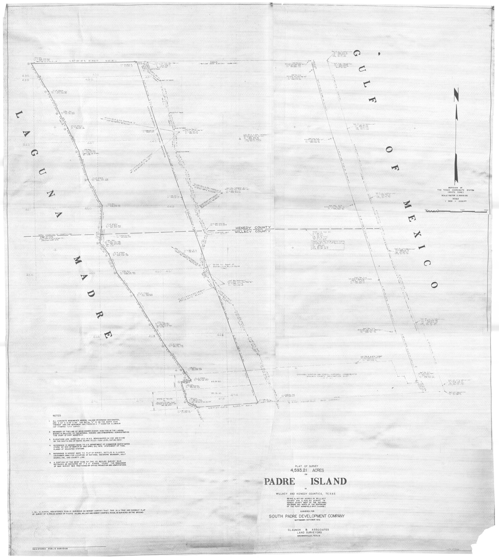
Plat of a survey on Padre Island in Willacy and Kenedy Counties surveyed for South Padre Development Corporation by Claunch and Associates
-
Map/Doc
61424
-
Collection
General Map Collection
-
Object Dates
1973 (Creation Date)
-
Counties
Willacy Kenedy
-
Height x Width
46.5 x 41.6 inches
118.1 x 105.7 cm
Part of: General Map Collection
Map of the Rio Grande & Eagle Pass Ry. from Sections 21-25 9/10 Inclusive, Webb County

Print $40.00
- Digital $50.00
Map of the Rio Grande & Eagle Pass Ry. from Sections 21-25 9/10 Inclusive, Webb County
1909
Size 25.8 x 55.4 inches
Map/Doc 64658
Close-up: USA - Arizona, New Mexico, Utah, Colorado

Close-up: USA - Arizona, New Mexico, Utah, Colorado
Size 35.0 x 22.9 inches
Map/Doc 96843
Palo Pinto County

Print $40.00
- Digital $50.00
Palo Pinto County
1941
Size 48.3 x 39.4 inches
Map/Doc 66966
Flight Mission No. DAH-9M, Frame 200, Orange County

Print $20.00
- Digital $50.00
Flight Mission No. DAH-9M, Frame 200, Orange County
1953
Size 18.6 x 22.4 inches
Map/Doc 86868
Big Lake Oil Field

Print $20.00
- Digital $50.00
Big Lake Oil Field
1924
Size 27.3 x 19.1 inches
Map/Doc 2420
Real County Working Sketch 48

Print $20.00
- Digital $50.00
Real County Working Sketch 48
1956
Size 29.4 x 18.5 inches
Map/Doc 71940
Jasper County Working Sketch 18

Print $20.00
- Digital $50.00
Jasper County Working Sketch 18
1934
Size 22.4 x 30.5 inches
Map/Doc 66480
Real County Working Sketch 34

Print $20.00
- Digital $50.00
Real County Working Sketch 34
1948
Size 25.6 x 29.0 inches
Map/Doc 71926
Coryell County Sketch File 25

Print $4.00
- Digital $50.00
Coryell County Sketch File 25
1873
Size 12.8 x 8.3 inches
Map/Doc 19391
Jackson County Sketch File 31

Print $18.00
- Digital $50.00
Jackson County Sketch File 31
1940
Size 14.4 x 8.4 inches
Map/Doc 27756
Pecos County Rolled Sketch 82

Print $20.00
- Digital $50.00
Pecos County Rolled Sketch 82
1930
Size 29.0 x 26.4 inches
Map/Doc 10192
Flight Mission No. DQO-8K, Frame 76, Galveston County

Print $20.00
- Digital $50.00
Flight Mission No. DQO-8K, Frame 76, Galveston County
1952
Size 18.6 x 22.5 inches
Map/Doc 85180
You may also like
Presidio County Working Sketch 110

Print $20.00
- Digital $50.00
Presidio County Working Sketch 110
1981
Size 38.7 x 32.2 inches
Map/Doc 71787
Lavaca County Rolled Sketch 4

Print $20.00
- Digital $50.00
Lavaca County Rolled Sketch 4
1961
Size 43.6 x 37.1 inches
Map/Doc 9420
Kimble County Working Sketch 9

Print $20.00
- Digital $50.00
Kimble County Working Sketch 9
1920
Size 14.3 x 17.3 inches
Map/Doc 70077
Part of South Half of Section 4, Block O

Print $20.00
- Digital $50.00
Part of South Half of Section 4, Block O
1953
Size 21.1 x 17.2 inches
Map/Doc 92780
Presidio County Rolled Sketch A-2

Print $20.00
- Digital $50.00
Presidio County Rolled Sketch A-2
1889
Size 36.9 x 43.9 inches
Map/Doc 9770
Map of Nacogdoches County

Print $20.00
- Digital $50.00
Map of Nacogdoches County
1857
Size 22.9 x 24.3 inches
Map/Doc 3907
Lavaca County Sketch File 8

Print $6.00
- Digital $50.00
Lavaca County Sketch File 8
1882
Size 10.7 x 10.3 inches
Map/Doc 29644
Map of the River Sabine from its mouth on the Gulf of Mexico in the sea to Logan's Ferry in latitude 31° 58' 24" north

Print $20.00
- Digital $50.00
Map of the River Sabine from its mouth on the Gulf of Mexico in the sea to Logan's Ferry in latitude 31° 58' 24" north
1842
Size 18.5 x 9.0 inches
Map/Doc 65384
Brewster County Working Sketch 87

Print $40.00
- Digital $50.00
Brewster County Working Sketch 87
1973
Size 37.4 x 56.6 inches
Map/Doc 67687
Map of the Interior of Louisiana with a part of New Mexico

Print $20.00
Map of the Interior of Louisiana with a part of New Mexico
1811
Size 11.1 x 14.2 inches
Map/Doc 94269
Kenedy County Working Sketch 2a

Print $20.00
- Digital $50.00
Kenedy County Working Sketch 2a
1907
Size 22.2 x 20.9 inches
Map/Doc 70003
General Highway Map, Lynn County, Texas

Print $20.00
General Highway Map, Lynn County, Texas
1961
Size 18.1 x 24.6 inches
Map/Doc 79580