Brewster County Sketch File D-1
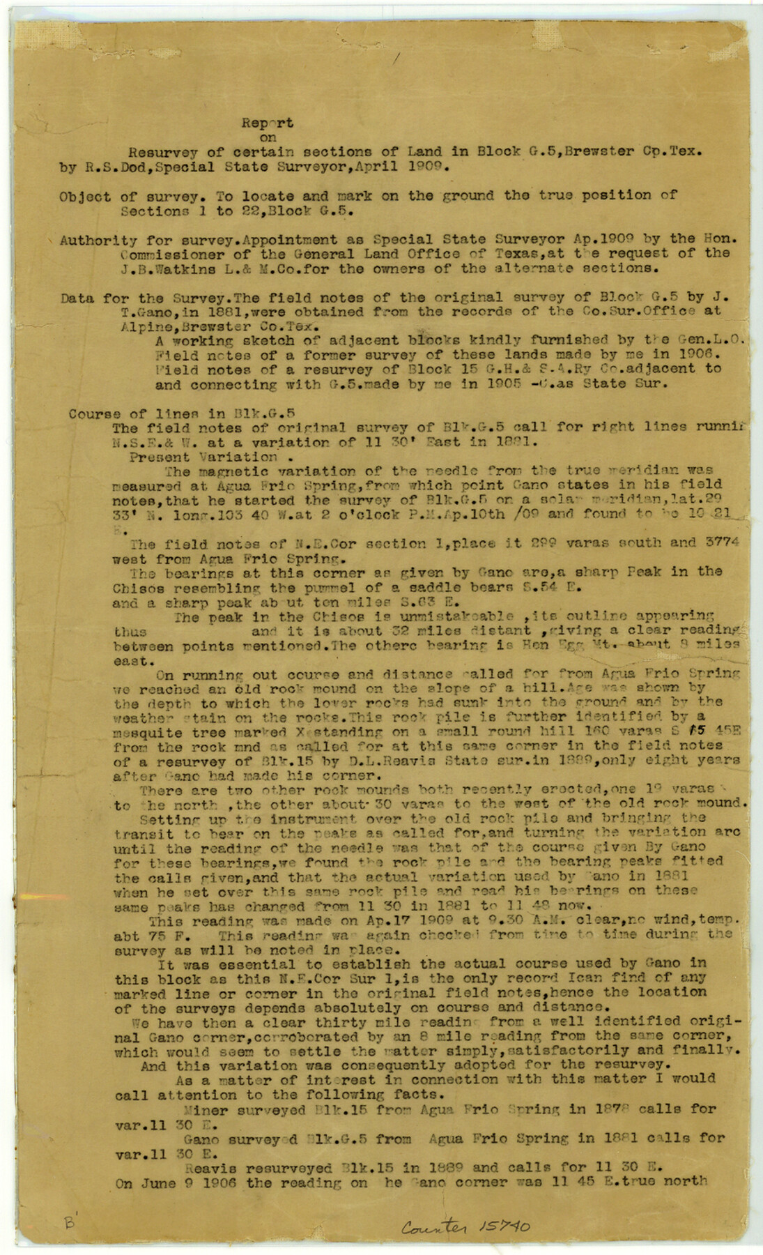
Report on resurvey of certain sections of land in Block G5, Brewster Co., Tex.
-
Map/Doc
15740
-
Collection
General Map Collection
-
Object Dates
1909 (Creation Date)
1938/5/9 (File Date)
-
People and Organizations
R.S. Dod (Surveyor/Engineer)
-
Counties
Brewster
-
Subjects
Surveying Sketch File
-
Height x Width
14.4 x 8.8 inches
36.6 x 22.4 cm
-
Medium
paper, print
-
Comments
See Brewster County Sketch File D (15738) for sketch.
-
Features
Red Peak
Christmas Mountain
Sawmill Mountain
Tablecloth Mountain
Burro Tinaja Mountain
Agua Frio Mountain
Almaden Mountain
Chisos Mountain
Mariposa Mountain
Porphyry Peak
Mount Emery
Corazon Peak
Hen Egg Mountain
Big Bend Mines
Painted Mountain
Joe Black Springs
Cigar Springs
Terlingua Creek
Chisos Mountains
Agua Frio Spring
Related maps
Brewster County Sketch File D

Print $4.00
- Digital $50.00
Brewster County Sketch File D
1938
Size 14.5 x 8.8 inches
Map/Doc 15738
Part of: General Map Collection
Burnet County Working Sketch 11

Print $20.00
- Digital $50.00
Burnet County Working Sketch 11
1975
Size 26.5 x 28.9 inches
Map/Doc 67854
Flight Mission No. DCL-4C, Frame 122, Kenedy County

Print $20.00
- Digital $50.00
Flight Mission No. DCL-4C, Frame 122, Kenedy County
1943
Size 18.6 x 22.3 inches
Map/Doc 85821
Flight Mission No. CGI-3N, Frame 134, Cameron County

Print $20.00
- Digital $50.00
Flight Mission No. CGI-3N, Frame 134, Cameron County
1954
Size 18.4 x 22.2 inches
Map/Doc 84607
Nueces County Rolled Sketch 81

Print $278.00
- Digital $50.00
Nueces County Rolled Sketch 81
1982
Size 24.3 x 36.2 inches
Map/Doc 6960
Menard County Sketch File 29

Print $20.00
- Digital $50.00
Menard County Sketch File 29
1962
Size 21.0 x 41.1 inches
Map/Doc 10543
Coke County Working Sketch 22

Print $20.00
- Digital $50.00
Coke County Working Sketch 22
1949
Size 21.7 x 27.7 inches
Map/Doc 68059
El Paso County Rolled Sketch 54

Print $20.00
- Digital $50.00
El Paso County Rolled Sketch 54
1980
Size 30.4 x 42.8 inches
Map/Doc 44539
Navigation Maps of Gulf Intracoastal Waterway, Port Arthur to Brownsville, Texas

Print $4.00
- Digital $50.00
Navigation Maps of Gulf Intracoastal Waterway, Port Arthur to Brownsville, Texas
1951
Size 16.7 x 21.4 inches
Map/Doc 65423
Denton County Sketch File 9

Print $6.00
- Digital $50.00
Denton County Sketch File 9
1856
Size 8.6 x 13.3 inches
Map/Doc 20705
South Part Crockett County

Print $40.00
- Digital $50.00
South Part Crockett County
1977
Size 39.1 x 51.2 inches
Map/Doc 95471
Mills County Working Sketch 13

Print $20.00
- Digital $50.00
Mills County Working Sketch 13
1943
Size 27.4 x 28.7 inches
Map/Doc 71043
Harrison County Working Sketch 19

Print $20.00
- Digital $50.00
Harrison County Working Sketch 19
1978
Size 31.8 x 33.1 inches
Map/Doc 66039
You may also like
Red River County Working Sketch 13

Print $20.00
- Digital $50.00
Red River County Working Sketch 13
1947
Size 37.1 x 39.9 inches
Map/Doc 71996
United States - Gulf Coast Texas - Southern part of Laguna Madre

Print $20.00
- Digital $50.00
United States - Gulf Coast Texas - Southern part of Laguna Madre
1933
Size 27.1 x 18.3 inches
Map/Doc 72950
Matagorda County Sketch File 26

Print $24.00
- Digital $50.00
Matagorda County Sketch File 26
1903
Size 14.4 x 8.7 inches
Map/Doc 30791
Bastrop County Boundary File 3

Print $48.00
- Digital $50.00
Bastrop County Boundary File 3
1925
Size 11.3 x 8.7 inches
Map/Doc 50320
Subdivision Map of Fisher County School Land situated in Bailey and Cochran Counties, Texas

Print $20.00
- Digital $50.00
Subdivision Map of Fisher County School Land situated in Bailey and Cochran Counties, Texas
1924
Size 20.0 x 29.6 inches
Map/Doc 90243
Flight Mission No. DQO-8K, Frame79, Galveston County

Print $20.00
- Digital $50.00
Flight Mission No. DQO-8K, Frame79, Galveston County
1952
Size 18.7 x 22.5 inches
Map/Doc 85183
Hutchinson County Rolled Sketch 22

Print $20.00
- Digital $50.00
Hutchinson County Rolled Sketch 22
1914
Size 29.3 x 38.0 inches
Map/Doc 6287
Palo Pinto County

Print $20.00
- Digital $50.00
Palo Pinto County
1941
Size 44.9 x 35.9 inches
Map/Doc 77389
Railroad Track Map, T&PRRCo., Culberson County, Texas

Print $4.00
- Digital $50.00
Railroad Track Map, T&PRRCo., Culberson County, Texas
1910
Size 11.7 x 18.6 inches
Map/Doc 62830
The Inca, Machu Picchu Salutes the Sun

The Inca, Machu Picchu Salutes the Sun
Size 20.4 x 31.3 inches
Map/Doc 95935
Shackelford County Rolled Sketch 4A

Print $40.00
- Digital $50.00
Shackelford County Rolled Sketch 4A
1984
Size 35.2 x 48.7 inches
Map/Doc 9917
Kinney County Working Sketch 38

Print $20.00
- Digital $50.00
Kinney County Working Sketch 38
1971
Size 28.9 x 30.6 inches
Map/Doc 70220