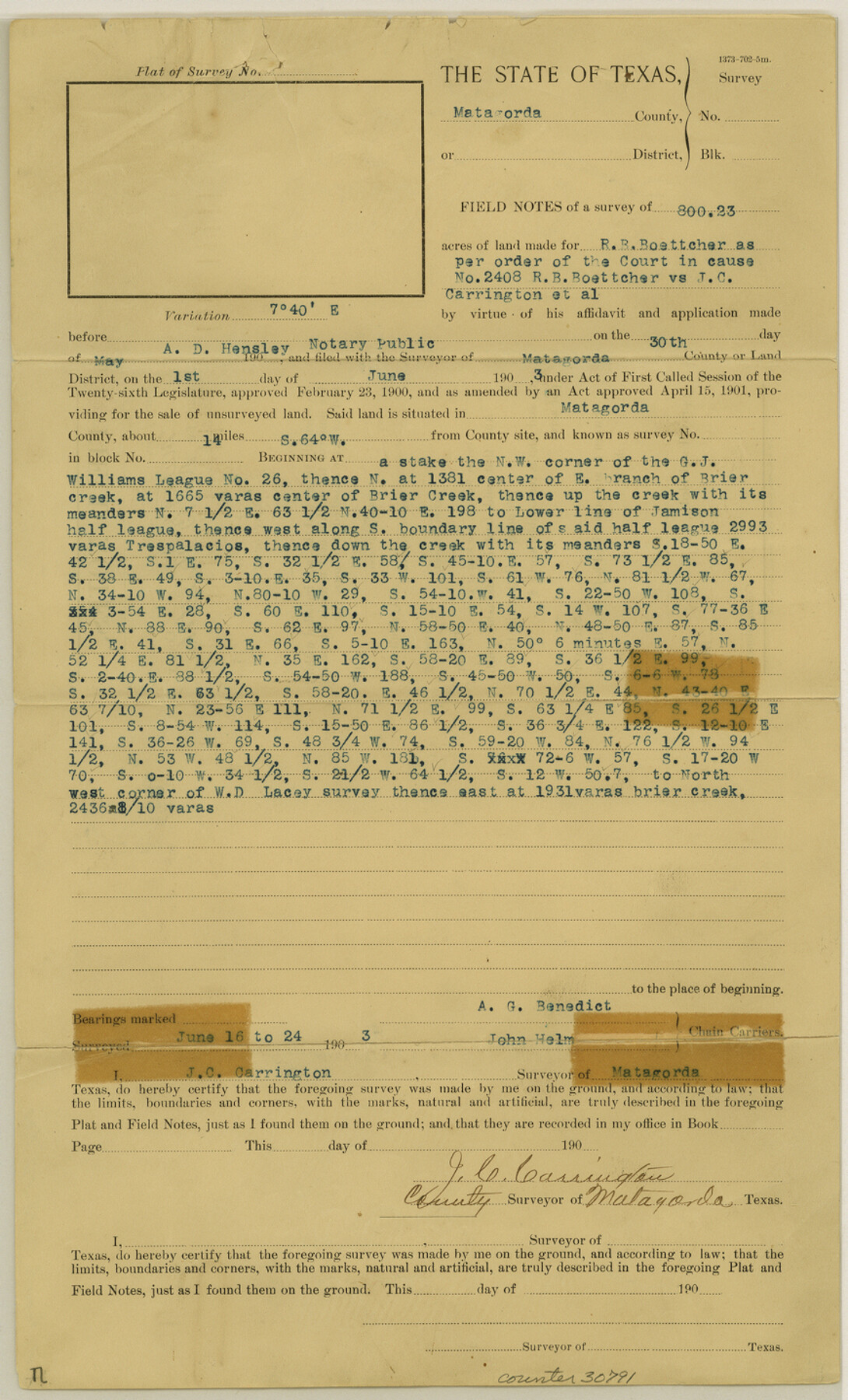
Matagorda County Sketch File 26
[Decree and Order - R. B. Boettcher vs. J. C. Carrington, et al]
-
Map/Doc
30791
-
Collection
General Map Collection
-
Object Dates
8/11/1903 (Creation Date)
8/14/1903 (File Date)
-
People and Organizations
G. Austin (Surveyor/Engineer)
-
Counties
Matagorda
-
Subjects
Surveying Sketch File
-
Height x Width
14.4 x 8.7 inches
36.6 x 22.1 cm
-
Medium
paper, print with manuscript additions
-
Features
Brier Creek
Trespalacios [sic] [Creek]
Church at Hawley
Hawley
Trespalacios [sic] Bayou
Bay City
West Fork of Brier Creek
Part of: General Map Collection

[Surveys along the Cibolo, Balcones and Leon Creeks]
![37, [Surveys along the Cibolo, Balcones and Leon Creeks], General Map Collection](https://historictexasmaps.com/wmedia_w700/maps/37.tif.jpg)
Print $2.00
- Digital $50.00
[Surveys along the Cibolo, Balcones and Leon Creeks]
1841
Size 13.3 x 7.8 inches
Map/Doc 37
Live Oak County Sketch File 26

Print $6.00
- Digital $50.00
Live Oak County Sketch File 26
1922
Size 7.1 x 8.6 inches
Map/Doc 30309
Guadalupe County Sketch File 26

Print $4.00
- Digital $50.00
Guadalupe County Sketch File 26
1873
Size 10.2 x 8.2 inches
Map/Doc 24719
El Paso County Working Sketch 32

Print $20.00
- Digital $50.00
El Paso County Working Sketch 32
1971
Size 40.2 x 38.3 inches
Map/Doc 69054
Montague County Working Sketch 4

Print $20.00
- Digital $50.00
Montague County Working Sketch 4
1920
Size 25.3 x 22.0 inches
Map/Doc 71070
Presidio County Sketch File 84

Print $20.00
- Digital $50.00
Presidio County Sketch File 84
1949
Size 15.2 x 37.2 inches
Map/Doc 11723
Hudspeth County Rolled Sketch 73

Print $40.00
- Digital $50.00
Hudspeth County Rolled Sketch 73
1992
Size 38.9 x 49.3 inches
Map/Doc 9236
Brazos County Sketch File 5

Print $34.00
- Digital $50.00
Brazos County Sketch File 5
1935
Size 8.2 x 7.1 inches
Map/Doc 15559
Williamson County Sketch File 32

Print $6.00
- Digital $50.00
Williamson County Sketch File 32
1986
Size 11.3 x 8.5 inches
Map/Doc 40393
Liberty County Working Sketch 44

Print $20.00
- Digital $50.00
Liberty County Working Sketch 44
1953
Size 21.3 x 30.2 inches
Map/Doc 70503
Crosby County Sketch File 26

Print $28.00
- Digital $50.00
Crosby County Sketch File 26
1888
Size 14.1 x 8.6 inches
Map/Doc 20098
You may also like
Hudspeth County Working Sketch 23

Print $40.00
- Digital $50.00
Hudspeth County Working Sketch 23
1967
Size 52.6 x 39.2 inches
Map/Doc 66305
Orange County Working Sketch 45

Print $20.00
- Digital $50.00
Orange County Working Sketch 45
1982
Size 25.6 x 24.2 inches
Map/Doc 71377
Flight Mission No. CRC-2R, Frame 188, Chambers County

Print $20.00
- Digital $50.00
Flight Mission No. CRC-2R, Frame 188, Chambers County
1956
Size 18.5 x 22.3 inches
Map/Doc 84766
[Sketch & Field Note Calls of Pecos, Terrell & Val Verde Counties, Texas]
![1720, [Sketch & Field Note Calls of Pecos, Terrell & Val Verde Counties, Texas], General Map Collection](https://historictexasmaps.com/wmedia_w700/pdf_converted_jpg/qi_pdf_thumbnail_734.jpg)
Print $20.00
- Digital $50.00
[Sketch & Field Note Calls of Pecos, Terrell & Val Verde Counties, Texas]
1915
Size 19.4 x 24.2 inches
Map/Doc 1720
Bexar County Sketch File 56

Print $40.00
- Digital $50.00
Bexar County Sketch File 56
1966
Size 19.7 x 23.8 inches
Map/Doc 10927
Duval County Working Sketch 42

Print $20.00
- Digital $50.00
Duval County Working Sketch 42
1976
Size 24.9 x 31.1 inches
Map/Doc 68766
Nueces County NRC Article 33.136 Sketch 2

Print $20.00
- Digital $50.00
Nueces County NRC Article 33.136 Sketch 2
2002
Size 29.3 x 44.4 inches
Map/Doc 61622
Presidio County Working Sketch 16

Print $20.00
- Digital $50.00
Presidio County Working Sketch 16
1942
Size 22.0 x 41.4 inches
Map/Doc 71692
Real County Working Sketch 71

Print $20.00
- Digital $50.00
Real County Working Sketch 71
1976
Size 31.8 x 29.1 inches
Map/Doc 71963
Flight Mission No. BRE-1P, Frame 105, Nueces County

Print $20.00
- Digital $50.00
Flight Mission No. BRE-1P, Frame 105, Nueces County
1956
Size 18.4 x 22.2 inches
Map/Doc 86676
Brazoria County Rolled Sketch 22

Print $20.00
- Digital $50.00
Brazoria County Rolled Sketch 22
1929
Size 28.1 x 40.8 inches
Map/Doc 10715
Flight Mission No. DQO-8K, Frame 41, Galveston County

Print $20.00
- Digital $50.00
Flight Mission No. DQO-8K, Frame 41, Galveston County
1952
Size 18.7 x 22.3 inches
Map/Doc 85148