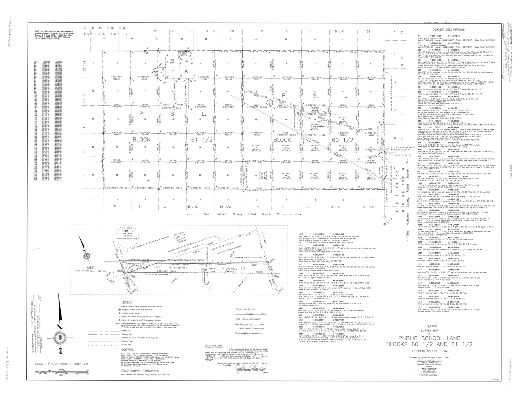
Hudspeth County Rolled Sketch 73
Survey map of Public School Land Blocks 60 1/2 and 61 1/2
-
Map/Doc
9236
-
Collection
General Map Collection
-
Object Dates
1992/4/1 (Creation Date)
1992/8/31 (File Date)
-
People and Organizations
Wm. C. Wilson, Jr. (Surveyor/Engineer)
Bart Johnson (Chainman/Field Personnel)
Lee Dressler (Chainman/Field Personnel)
Larry McGuire (Chainman/Field Personnel)
Kerry Flint (Chainman/Field Personnel)
-
Counties
Hudspeth
-
Subjects
Surveying Rolled Sketch
-
Height x Width
38.9 x 49.3 inches
98.8 x 125.2 cm
-
Medium
mylar, print
-
Scale
1" = 720 varas
Part of: General Map Collection
Map from Corpus Christi to Matagorda Bays, Texas [Inset: Survey of the channel of Copono Bay]
![72973, Map from Corpus Christi to Matagorda Bays, Texas [Inset: Survey of the channel of Copono Bay], General Map Collection](https://historictexasmaps.com/wmedia_w700/maps/72973.tif.jpg)
Print $20.00
- Digital $50.00
Map from Corpus Christi to Matagorda Bays, Texas [Inset: Survey of the channel of Copono Bay]
1846
Size 18.2 x 27.5 inches
Map/Doc 72973
Brewster County Sketch File N-8

Print $12.00
- Digital $50.00
Brewster County Sketch File N-8
1914
Size 10.8 x 8.6 inches
Map/Doc 15610
Harbor Pass and Bar at Brazos Santiago, Texas

Print $20.00
- Digital $50.00
Harbor Pass and Bar at Brazos Santiago, Texas
1871
Size 18.1 x 27.4 inches
Map/Doc 73038
El Paso County Working Sketch 7

Print $20.00
- Digital $50.00
El Paso County Working Sketch 7
1928
Size 25.7 x 16.9 inches
Map/Doc 69029
Starr County Sketch File 25

Print $42.00
- Digital $50.00
Starr County Sketch File 25
1921
Size 9.1 x 8.6 inches
Map/Doc 36927
Township 2 North Range 12 West, North Western District, Louisiana

Print $20.00
- Digital $50.00
Township 2 North Range 12 West, North Western District, Louisiana
1884
Size 19.6 x 24.7 inches
Map/Doc 65875
Public Land on Mustang Island, Nueces County

Print $20.00
- Digital $50.00
Public Land on Mustang Island, Nueces County
1910
Size 17.0 x 17.5 inches
Map/Doc 1997
Cameron County Rolled Sketch 25

Print $20.00
- Digital $50.00
Cameron County Rolled Sketch 25
1977
Size 24.6 x 36.7 inches
Map/Doc 5796
San Jacinto County Rolled Sketch 14

Print $20.00
- Digital $50.00
San Jacinto County Rolled Sketch 14
1998
Size 26.5 x 37.3 inches
Map/Doc 7568
Andrews County Rolled Sketch 20

Print $20.00
- Digital $50.00
Andrews County Rolled Sketch 20
Size 31.6 x 40.0 inches
Map/Doc 8395
El Paso County Boundary File 10

Print $14.00
- Digital $50.00
El Paso County Boundary File 10
Size 12.7 x 8.2 inches
Map/Doc 53118
El Paso County Working Sketch Graphic Index - north part

Print $20.00
- Digital $50.00
El Paso County Working Sketch Graphic Index - north part
1977
Size 33.4 x 45.0 inches
Map/Doc 76536
You may also like
Flight Mission No. DQO-11K, Frame 17, Galveston County

Print $20.00
- Digital $50.00
Flight Mission No. DQO-11K, Frame 17, Galveston County
1952
Size 18.7 x 22.4 inches
Map/Doc 85210
[Texas Gulf Coast from Rio Grande to Sabine Lake]
![72686, [Texas Gulf Coast from Rio Grande to Sabine Lake], General Map Collection](https://historictexasmaps.com/wmedia_w700/maps/72686.tif.jpg)
Print $20.00
- Digital $50.00
[Texas Gulf Coast from Rio Grande to Sabine Lake]
Size 28.0 x 18.3 inches
Map/Doc 72686
[Sketch for Mineral Application 14125 - Neches River, R. B. Moore]
![65668, [Sketch for Mineral Application 14125 - Neches River, R. B. Moore], General Map Collection](https://historictexasmaps.com/wmedia_w700/maps/65668.tif.jpg)
Print $40.00
- Digital $50.00
[Sketch for Mineral Application 14125 - Neches River, R. B. Moore]
1928
Size 50.1 x 26.6 inches
Map/Doc 65668
University Land, Lamar County

Print $20.00
- Digital $50.00
University Land, Lamar County
1906
Size 23.8 x 29.9 inches
Map/Doc 2431
Coleman County Sketch File 46

Print $20.00
- Digital $50.00
Coleman County Sketch File 46
1894
Size 24.0 x 21.8 inches
Map/Doc 11125
Frio County Working Sketch 13

Print $20.00
- Digital $50.00
Frio County Working Sketch 13
1954
Size 23.3 x 35.5 inches
Map/Doc 69287
Erath County Sketch File 3b

Print $4.00
- Digital $50.00
Erath County Sketch File 3b
Size 10.3 x 8.3 inches
Map/Doc 22257
Reeves County Working Sketch 46

Print $40.00
- Digital $50.00
Reeves County Working Sketch 46
1974
Size 52.4 x 37.2 inches
Map/Doc 63489
Upton County Rolled Sketch 55

Print $40.00
- Digital $50.00
Upton County Rolled Sketch 55
Size 192.5 x 25.4 inches
Map/Doc 10060
Map of Comanche County

Print $20.00
Map of Comanche County
1876
Size 28.0 x 24.1 inches
Map/Doc 88919
Recharge zone of the Edwards Aquifer hydrologically associated with Barton Springs in the Austin Area, Texas

Print $20.00
- Digital $50.00
Recharge zone of the Edwards Aquifer hydrologically associated with Barton Springs in the Austin Area, Texas
1986
Size 41.5 x 29.3 inches
Map/Doc 60400
Flight Mission No. BRA-16M, Frame 62, Jefferson County

Print $20.00
- Digital $50.00
Flight Mission No. BRA-16M, Frame 62, Jefferson County
1953
Size 18.7 x 22.4 inches
Map/Doc 85679