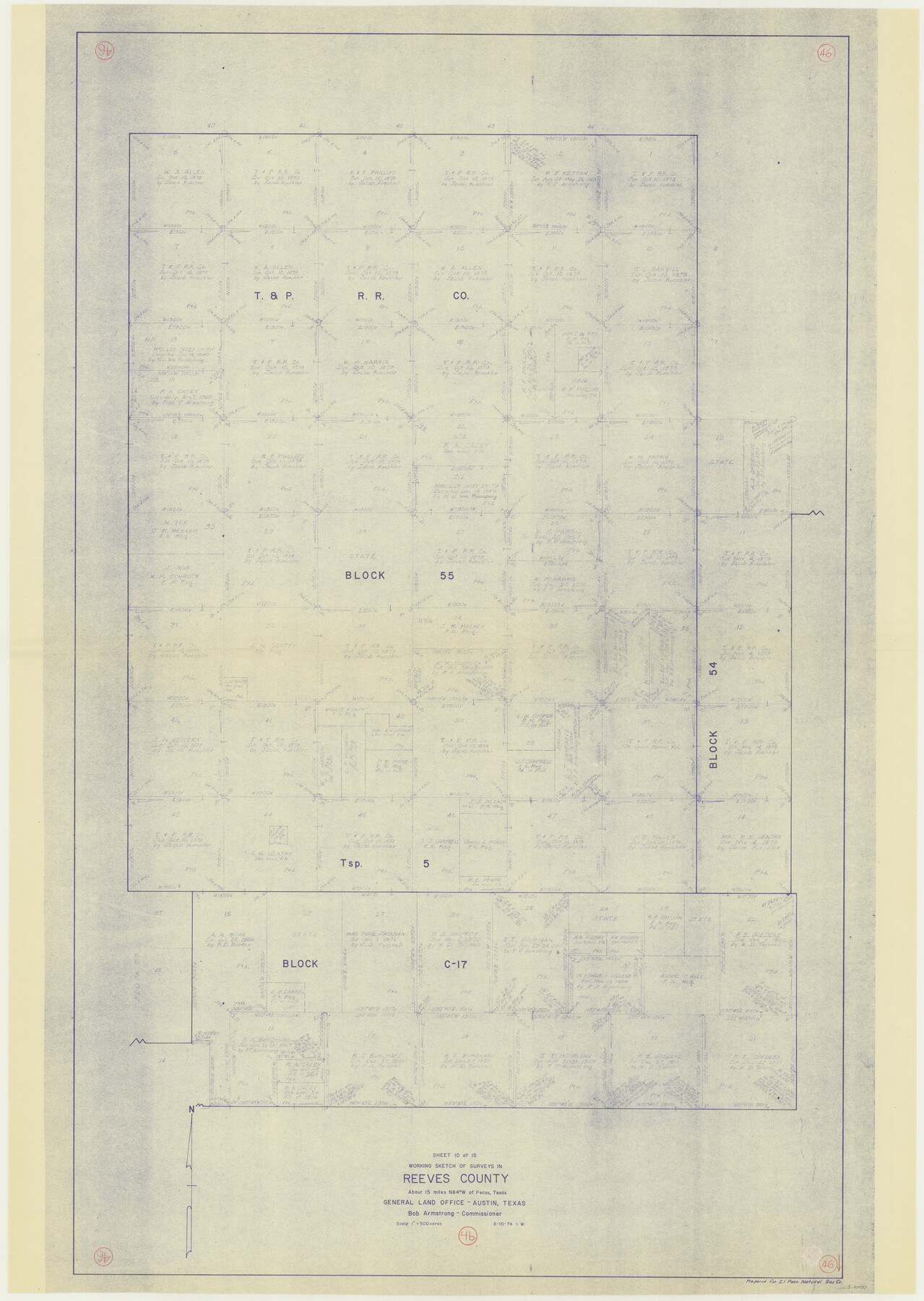
Reeves County Working Sketch 46
-
Map/Doc
63489
-
Collection
General Map Collection
-
Object Dates
6/10/1974 (Creation Date)
-
Counties
Reeves
-
Subjects
Surveying Working Sketch
-
Height x Width
52.4 x 37.2 inches
133.1 x 94.5 cm
-
Scale
1" = 500 varas
Part of: General Map Collection
Trinity County Sketch File 5

Print $64.00
- Digital $50.00
Trinity County Sketch File 5
1909
Size 17.9 x 28.8 inches
Map/Doc 12482
Hidalgo County

Print $20.00
- Digital $50.00
Hidalgo County
1911
Size 42.1 x 29.6 inches
Map/Doc 66863
Marion County Working Sketch 22

Print $20.00
- Digital $50.00
Marion County Working Sketch 22
1960
Size 34.3 x 27.5 inches
Map/Doc 70798
Fannin County Sketch File 20b

Print $4.00
- Digital $50.00
Fannin County Sketch File 20b
1890
Size 14.2 x 8.9 inches
Map/Doc 22485
Polk County Working Sketch 14

Print $20.00
- Digital $50.00
Polk County Working Sketch 14
1945
Size 32.3 x 37.7 inches
Map/Doc 71629
Travis County Working Sketch 67

Print $20.00
- Digital $50.00
Travis County Working Sketch 67
2017
Size 24.6 x 36.6 inches
Map/Doc 94123
Rusk County Sketch File 44

Print $12.00
Rusk County Sketch File 44
1951
Size 11.3 x 8.9 inches
Map/Doc 35585
Flight Mission No. CRE-1R, Frame 66, Jackson County

Print $20.00
- Digital $50.00
Flight Mission No. CRE-1R, Frame 66, Jackson County
1956
Size 16.2 x 16.1 inches
Map/Doc 85329
Map of Harris County

Print $20.00
- Digital $50.00
Map of Harris County
1893
Size 23.9 x 32.2 inches
Map/Doc 3633
Val Verde County Working Sketch 121

Print $40.00
- Digital $50.00
Val Verde County Working Sketch 121
2005
Size 34.0 x 54.2 inches
Map/Doc 83590
Brazoria County Rolled Sketch 49

Print $20.00
- Digital $50.00
Brazoria County Rolled Sketch 49
1948
Size 23.8 x 36.2 inches
Map/Doc 5184
Stephens County

Print $20.00
- Digital $50.00
Stephens County
1940
Size 42.4 x 40.7 inches
Map/Doc 95644
You may also like
Montgomery County Sketch File 32

Print $10.00
- Digital $50.00
Montgomery County Sketch File 32
1933
Size 10.8 x 7.8 inches
Map/Doc 31888
General Highway Map, Blanco County, Texas

Print $20.00
General Highway Map, Blanco County, Texas
1940
Size 25.0 x 18.5 inches
Map/Doc 79020
Coke County Rolled Sketch 23

Print $20.00
- Digital $50.00
Coke County Rolled Sketch 23
1944
Size 13.7 x 14.7 inches
Map/Doc 5524
Lampasas County Boundary File 13

Print $8.00
- Digital $50.00
Lampasas County Boundary File 13
Size 14.1 x 8.6 inches
Map/Doc 56194

Right-of-Way and Track Map, Texas State Railroad operated by the T. and N. O. R.R. Co.

Print $40.00
- Digital $50.00
Right-of-Way and Track Map, Texas State Railroad operated by the T. and N. O. R.R. Co.
1917
Size 24.3 x 55.7 inches
Map/Doc 64176
Eastland County Sketch File 6

Print $4.00
- Digital $50.00
Eastland County Sketch File 6
1871
Size 8.3 x 12.8 inches
Map/Doc 21572
Henderson County Working Sketch 41

Print $20.00
- Digital $50.00
Henderson County Working Sketch 41
1985
Size 28.8 x 17.0 inches
Map/Doc 66174
Brazoria County Sketch File 32

Print $60.00
- Digital $50.00
Brazoria County Sketch File 32
1896
Size 14.1 x 16.2 inches
Map/Doc 10955
[Blocks 3, 5 & Q]
![91275, [Blocks 3, 5 & Q], Twichell Survey Records](https://historictexasmaps.com/wmedia_w700/maps/91275-1.tif.jpg)
Print $20.00
- Digital $50.00
[Blocks 3, 5 & Q]
Size 19.4 x 9.2 inches
Map/Doc 91275
Railroad Track Map, H&TCRRCo., Falls County, Texas

Print $4.00
- Digital $50.00
Railroad Track Map, H&TCRRCo., Falls County, Texas
1918
Size 11.6 x 18.6 inches
Map/Doc 62848
Jeff Davis County Sketch File 23

Print $4.00
- Digital $50.00
Jeff Davis County Sketch File 23
1927
Size 13.3 x 8.8 inches
Map/Doc 27990