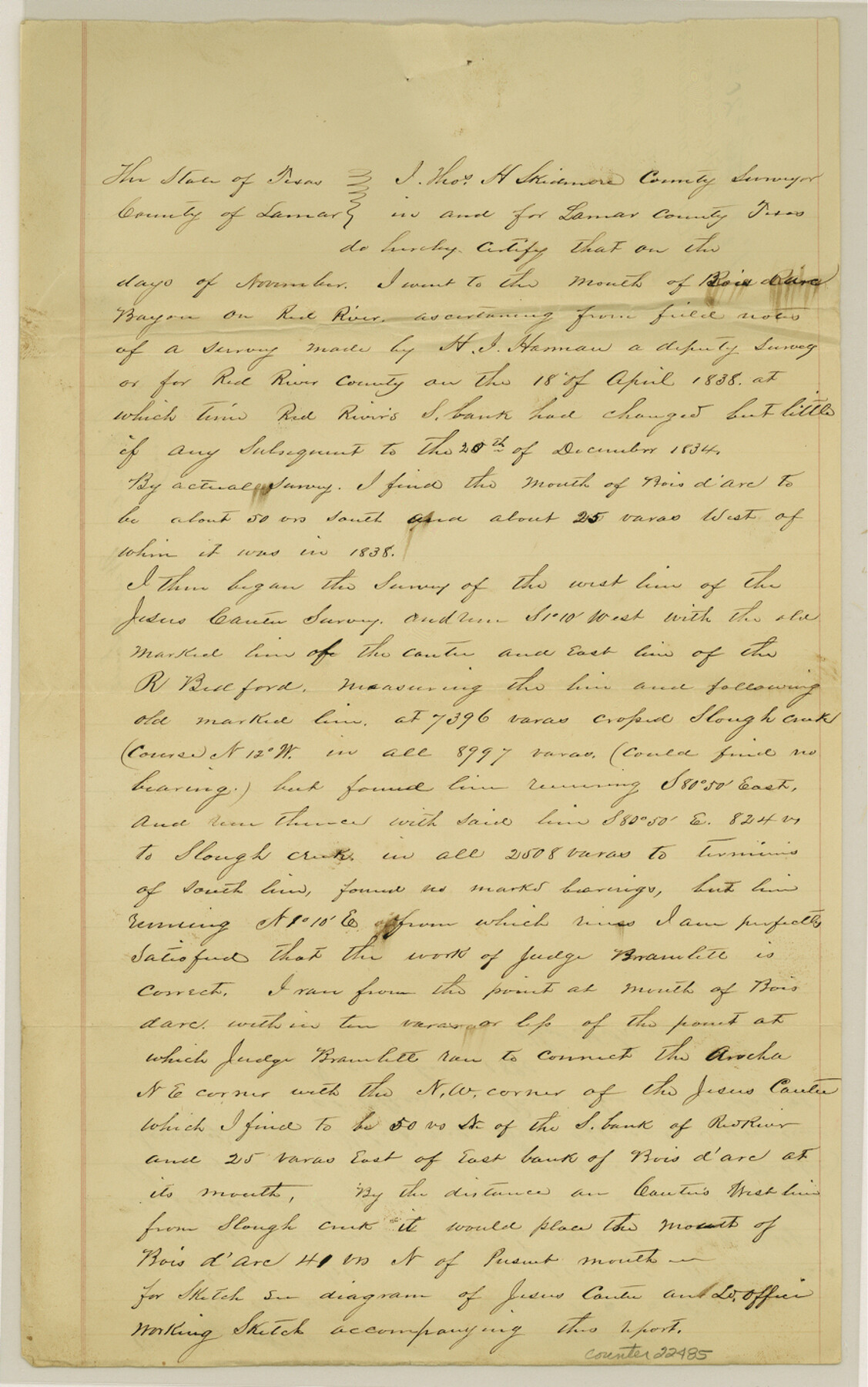
Fannin County Sketch File 20b
[Letter of correction of variation]
-
Map/Doc
22485
-
Collection
General Map Collection
-
Object Dates
1890/12/4 (Creation Date)
1891/1/17 (File Date)
1838/4/18 (Survey Date)
-
People and Organizations
Thomas H. Skidmore (Surveyor/Engineer)
[William] Bramlett (Surveyor/Engineer)
-
Counties
Fannin Red River
-
Subjects
Surveying Sketch File
-
Height x Width
14.2 x 8.9 inches
36.1 x 22.6 cm
-
Medium
paper, manuscript
-
Features
Bois d'Arc Bayou
Red River
Slough Creek
Part of: General Map Collection
Hudspeth County Working Sketch 36

Print $40.00
- Digital $50.00
Hudspeth County Working Sketch 36
1977
Size 63.1 x 37.2 inches
Map/Doc 66321
Zavala County Working Sketch 18

Print $20.00
- Digital $50.00
Zavala County Working Sketch 18
1977
Size 43.8 x 42.1 inches
Map/Doc 62093

Harris County Working Sketch 83

Print $20.00
- Digital $50.00
Harris County Working Sketch 83
1970
Size 26.0 x 30.1 inches
Map/Doc 65975
United States Great Lakes and adjacent waterways

Print $20.00
- Digital $50.00
United States Great Lakes and adjacent waterways
Size 20.8 x 42.2 inches
Map/Doc 76121
Terrell County Rolled Sketch JAS

Print $40.00
- Digital $50.00
Terrell County Rolled Sketch JAS
1936
Size 48.5 x 40.0 inches
Map/Doc 9988
Nacogdoches County Sketch File 14

Print $42.00
- Digital $50.00
Nacogdoches County Sketch File 14
1926
Size 8.8 x 11.3 inches
Map/Doc 32259
Midland County Sketch File 1

Print $20.00
- Digital $50.00
Midland County Sketch File 1
1886
Size 25.7 x 16.1 inches
Map/Doc 12079
Flight Mission No. BQR-9K, Frame 53, Brazoria County

Print $20.00
- Digital $50.00
Flight Mission No. BQR-9K, Frame 53, Brazoria County
1952
Size 18.7 x 22.3 inches
Map/Doc 84057
Navarro County Sketch File 20

Print $14.00
- Digital $50.00
Navarro County Sketch File 20
1967
Size 14.3 x 8.8 inches
Map/Doc 32343
Montague County Sketch File 19

Print $6.00
- Digital $50.00
Montague County Sketch File 19
1924
Size 11.2 x 8.5 inches
Map/Doc 31748
Map of Texas and Adjacent Regions in the Eighteenth Century

Print $20.00
- Digital $50.00
Map of Texas and Adjacent Regions in the Eighteenth Century
1915
Size 16.7 x 20.0 inches
Map/Doc 94007
You may also like
Matagorda County Working Sketch 33

Print $20.00
- Digital $50.00
Matagorda County Working Sketch 33
1998
Size 32.0 x 42.5 inches
Map/Doc 70891
Henderson County

Print $40.00
- Digital $50.00
Henderson County
1988
Size 30.8 x 63.0 inches
Map/Doc 77310
2017 Official Travel Map, Texas

2017 Official Travel Map, Texas
2017
Size 33.6 x 36.4 inches
Map/Doc 94415
[Sketch showing Panhandle and Santa Fe Railroad, Compress Spur and Seed House structures]
![92880, [Sketch showing Panhandle and Santa Fe Railroad, Compress Spur and Seed House structures], Twichell Survey Records](https://historictexasmaps.com/wmedia_w700/maps/92880-1.tif.jpg)
Print $20.00
- Digital $50.00
[Sketch showing Panhandle and Santa Fe Railroad, Compress Spur and Seed House structures]
Size 20.8 x 22.8 inches
Map/Doc 92880
Galveston County Rolled Sketch 39

Print $20.00
- Digital $50.00
Galveston County Rolled Sketch 39
Size 18.1 x 21.5 inches
Map/Doc 45207
[Texas Central Railway through Callahan County]
![64240, [Texas Central Railway through Callahan County], General Map Collection](https://historictexasmaps.com/wmedia_w700/maps/64240-1.tif.jpg)
Print $40.00
- Digital $50.00
[Texas Central Railway through Callahan County]
Size 24.6 x 86.3 inches
Map/Doc 64240

Red River County Sketch File 17b

Print $4.00
- Digital $50.00
Red River County Sketch File 17b
1875
Size 12.9 x 8.1 inches
Map/Doc 35147

Smith County Rolled Sketch 8

Print $20.00
- Digital $50.00
Smith County Rolled Sketch 8
2006
Size 24.7 x 37.0 inches
Map/Doc 95411
Tyler County Working Sketch 15

Print $20.00
- Digital $50.00
Tyler County Working Sketch 15
1960
Size 23.8 x 18.1 inches
Map/Doc 69485
Flight Mission No. BRA-6M, Frame 84, Jefferson County

Print $20.00
- Digital $50.00
Flight Mission No. BRA-6M, Frame 84, Jefferson County
1953
Size 18.6 x 22.4 inches
Map/Doc 85428