Galveston County Rolled Sketch 39
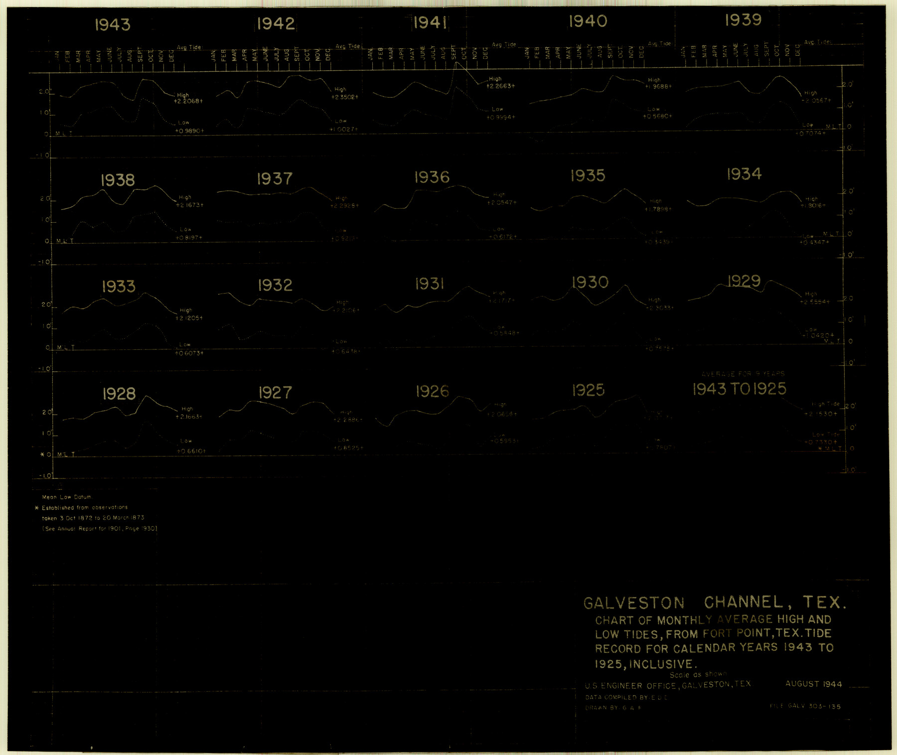
Galveston Channel, Chart of Monthly Average High and Low Tides, From Fort Point, Texas Tide Record for Calendar Years 1943 to 1925, Inclusive, Galveston County, Texas
-
Map/Doc
45207
-
Collection
General Map Collection
-
Counties
Galveston
-
Subjects
Surveying Rolled Sketch
-
Height x Width
18.1 x 21.5 inches
46.0 x 54.6 cm
Part of: General Map Collection
Concho County Sketch File 40

Print $26.00
- Digital $50.00
Concho County Sketch File 40
1949
Size 11.3 x 8.7 inches
Map/Doc 19194
Nautical Chart 887-SC Intracoastal Waterway - Galveston Bay to Cedar Lakes including the Brazos and San Bernard Rivers, Texas

Print $40.00
- Digital $50.00
Nautical Chart 887-SC Intracoastal Waterway - Galveston Bay to Cedar Lakes including the Brazos and San Bernard Rivers, Texas
1971
Size 15.7 x 59.5 inches
Map/Doc 69938
Tyler County Working Sketch 6

Print $20.00
- Digital $50.00
Tyler County Working Sketch 6
1934
Size 24.3 x 36.5 inches
Map/Doc 69476
Hidalgo County Rolled Sketch 18

Print $20.00
- Digital $50.00
Hidalgo County Rolled Sketch 18
Size 34.0 x 18.3 inches
Map/Doc 6213
Portion of States Submerged Area in Matagorda Bay

Print $20.00
- Digital $50.00
Portion of States Submerged Area in Matagorda Bay
1921
Size 15.7 x 15.1 inches
Map/Doc 2950
Galveston County Rolled Sketch 22

Print $20.00
- Digital $50.00
Galveston County Rolled Sketch 22
1953
Size 29.6 x 40.8 inches
Map/Doc 9083
Ector County Working Sketch 27

Print $20.00
- Digital $50.00
Ector County Working Sketch 27
Size 28.0 x 32.7 inches
Map/Doc 68870
Nueces County Sketch File 34

Print $6.00
- Digital $50.00
Nueces County Sketch File 34
1908
Size 11.6 x 12.9 inches
Map/Doc 32611
Archer County Working Sketch 18

Print $20.00
- Digital $50.00
Archer County Working Sketch 18
1957
Size 20.2 x 22.9 inches
Map/Doc 67159
Austin County Sketch File 14

Print $40.00
- Digital $50.00
Austin County Sketch File 14
Size 18.8 x 8.8 inches
Map/Doc 13880
Ector County Working Sketch 30

Print $40.00
- Digital $50.00
Ector County Working Sketch 30
1971
Size 43.2 x 64.1 inches
Map/Doc 68873

You may also like
A Geographically Correct County Map of States Traversed by the St. Louis, Iron Mountain & Southern Railway and its Connections

Print $20.00
- Digital $50.00
A Geographically Correct County Map of States Traversed by the St. Louis, Iron Mountain & Southern Railway and its Connections
1876
Size 18.6 x 15.9 inches
Map/Doc 95781
McMullen County Rolled Sketch 18

Print $20.00
- Digital $50.00
McMullen County Rolled Sketch 18
Size 18.8 x 27.5 inches
Map/Doc 6734
Presidio County Working Sketch 74

Print $20.00
- Digital $50.00
Presidio County Working Sketch 74
1962
Size 45.9 x 35.2 inches
Map/Doc 71751
Mills County Sketch File 1

Print $8.00
- Digital $50.00
Mills County Sketch File 1
1853
Size 11.6 x 12.7 inches
Map/Doc 31641
Harris County Working Sketch 100

Print $20.00
- Digital $50.00
Harris County Working Sketch 100
1979
Size 29.9 x 31.3 inches
Map/Doc 65992
Dickens County Sketch File H4

Print $4.00
- Digital $50.00
Dickens County Sketch File H4
Size 9.1 x 14.8 inches
Map/Doc 20881
La Salle County Boundary File 57a

Print $6.00
- Digital $50.00
La Salle County Boundary File 57a
Size 14.3 x 8.8 inches
Map/Doc 56255

Stonewall County Rolled Sketch 21

Print $40.00
- Digital $50.00
Stonewall County Rolled Sketch 21
1953
Size 50.8 x 47.9 inches
Map/Doc 9960
Garza County Rolled Sketch 11

Print $20.00
- Digital $50.00
Garza County Rolled Sketch 11
1915
Size 31.6 x 20.8 inches
Map/Doc 6000
[Sketch of Col. Cooke's Military Road expedition from Red River to Austin]
![82146, [Sketch of Col. Cooke's Military Road expedition from Red River to Austin], General Map Collection](https://historictexasmaps.com/wmedia_w700/maps/82146-1.tif.jpg)
Print $20.00
- Digital $50.00
[Sketch of Col. Cooke's Military Road expedition from Red River to Austin]
Size 33.4 x 23.4 inches
Map/Doc 82146
A Map of Part of Panola County [Judicial District]
![328, A Map of Part of Panola County [Judicial District], General Map Collection](https://historictexasmaps.com/wmedia_w700/maps/328.tif.jpg)
Print $20.00
- Digital $50.00
A Map of Part of Panola County [Judicial District]
1841
Size 18.3 x 15.4 inches
Map/Doc 328