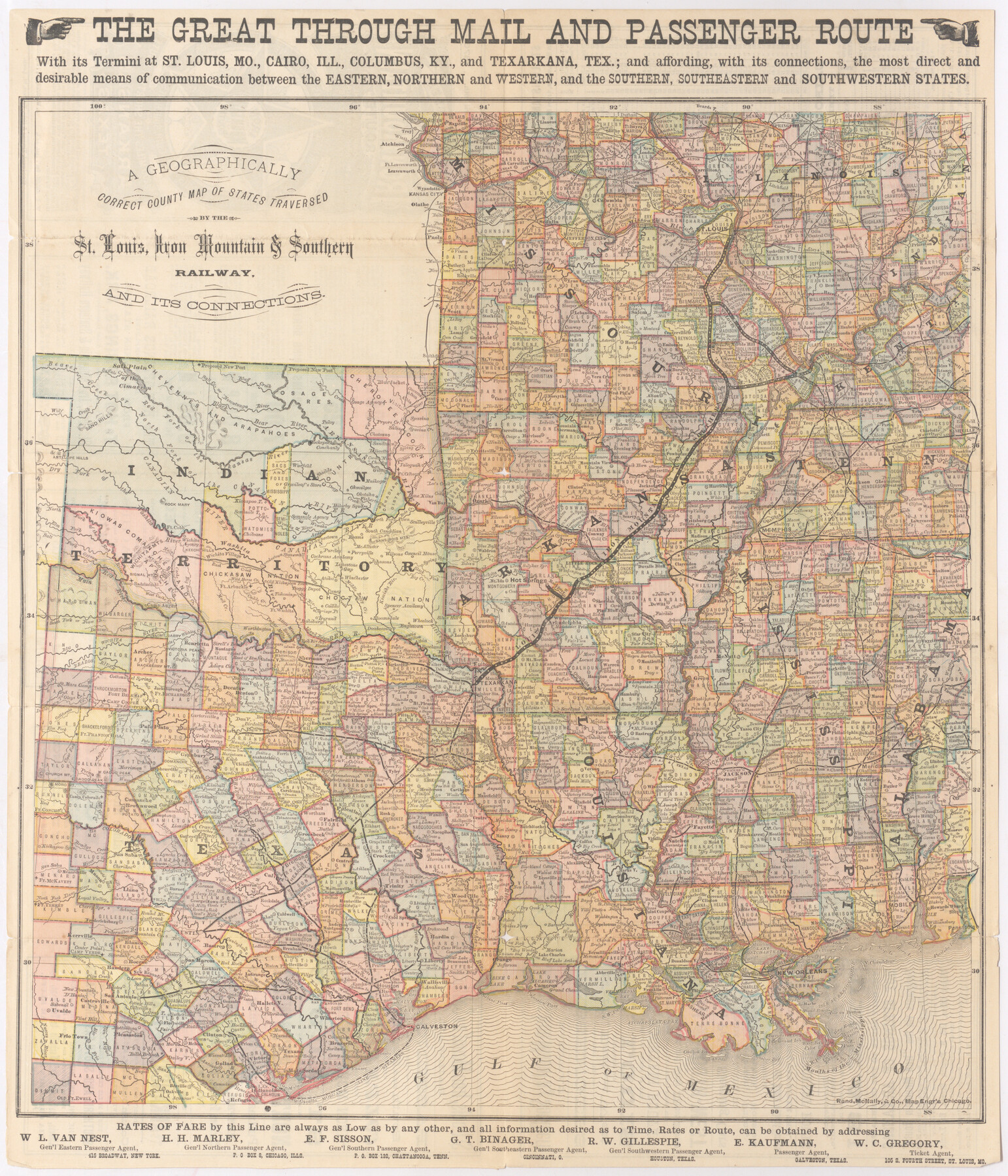
A Geographically Correct County Map of States Traversed by the St. Louis, Iron Mountain & Southern Railway and its Connections
The Iron Mountain Route
-
Map/Doc
95781
-
Collection
Cobb Digital Map Collection
-
Object Dates
1876 (Creation Date)
-
People and Organizations
Rand, McNally, & Co. (Printer)
-
Subjects
Railroads
-
Height x Width
18.6 x 15.9 inches
47.2 x 40.4 cm
-
Medium
digital image
-
Comments
Courtesy of John & Diana Cobb.
To view time tables and other information on reverse, click "Download PDF" link above.
Part of: Cobb Digital Map Collection
A New and Correct County Map of the State of Texas

Print $20.00
- Digital $50.00
A New and Correct County Map of the State of Texas
1891
Size 22.4 x 27.3 inches
Map/Doc 95760
Map of the N. Orleans, Mobile and Texas Railroad and Connections

Print $20.00
- Digital $50.00
Map of the N. Orleans, Mobile and Texas Railroad and Connections
1871
Size 8.9 x 11.1 inches
Map/Doc 96611

Panhandle of Texas

Print $20.00
- Digital $50.00
Panhandle of Texas
1907
Size 11.4 x 14.4 inches
Map/Doc 95889
Missouri, Kansas, & Texas Ry.

Print $20.00
- Digital $50.00
Missouri, Kansas, & Texas Ry.
Size 6.7 x 5.4 inches
Map/Doc 96598
I. & G. N. - International and Great Northern R.R. - International Route - Galveston, Ft. Worth, Waco, Houston, Austin, Laredo, San Antonio

Print $20.00
- Digital $50.00
I. & G. N. - International and Great Northern R.R. - International Route - Galveston, Ft. Worth, Waco, Houston, Austin, Laredo, San Antonio
1910
Size 24.0 x 16.2 inches
Map/Doc 95779
San Benito, Texas on the Frisco in the Lower Rio Grande Valley

San Benito, Texas on the Frisco in the Lower Rio Grande Valley
1911
Map/Doc 96727

Capitol Land and Investment Company's List of Texas Lands

Capitol Land and Investment Company's List of Texas Lands
1907
Size 7.9 x 5.2 inches
Map/Doc 97052

![[San Benito Promotional Booklet]](https://historictexasmaps.com/wmedia_w700/pdf_converted_jpg/qi_pdf_thumbnail_64211.jpg)
Phelps's National Map of the United States, a Travellers Guide. Embracing the principal railroads, canals, steamboat & stage routes, throughout the Union

Print $20.00
- Digital $50.00
Phelps's National Map of the United States, a Travellers Guide. Embracing the principal railroads, canals, steamboat & stage routes, throughout the Union
1849
Size 20.9 x 26.3 inches
Map/Doc 95901
You may also like
Culberson County Working Sketch 35

Print $20.00
- Digital $50.00
Culberson County Working Sketch 35
1963
Size 23.6 x 24.0 inches
Map/Doc 68488
Nueces River, Corpus Christi Sheet No. 4

Print $20.00
- Digital $50.00
Nueces River, Corpus Christi Sheet No. 4
1938
Size 32.3 x 42.8 inches
Map/Doc 65092
Marion County Rolled Sketch 9A

Print $20.00
- Digital $50.00
Marion County Rolled Sketch 9A
2001
Size 22.9 x 22.9 inches
Map/Doc 76419
Rains County Sketch File 9

Print $20.00
- Digital $50.00
Rains County Sketch File 9
Size 14.2 x 16.3 inches
Map/Doc 34960

Edwards County Working Sketch 28

Print $20.00
- Digital $50.00
Edwards County Working Sketch 28
1946
Size 30.0 x 33.5 inches
Map/Doc 68904
Flight Mission No. DCL-4C, Frame 6, Kenedy County

Print $20.00
- Digital $50.00
Flight Mission No. DCL-4C, Frame 6, Kenedy County
1943
Size 18.6 x 22.2 inches
Map/Doc 85807
Newton County Sketch File 9

Print $4.00
- Digital $50.00
Newton County Sketch File 9
Size 9.8 x 8.3 inches
Map/Doc 32378
Dawson County Rolled Sketch 7
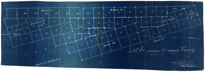
Print $20.00
- Digital $50.00
Dawson County Rolled Sketch 7
Size 14.1 x 38.1 inches
Map/Doc 5693
Coleman County Working Sketch 7

Print $20.00
- Digital $50.00
Coleman County Working Sketch 7
1942
Size 38.0 x 47.8 inches
Map/Doc 68073
Contracted Boundaries and Timeline of Mexican Empresario Colonies in Texas

Contracted Boundaries and Timeline of Mexican Empresario Colonies in Texas
2025
Size 17.0 x 11.0 inches
Map/Doc 97439
Glasscock County Working Sketch 11

Print $40.00
- Digital $50.00
Glasscock County Working Sketch 11
1957
Size 87.4 x 36.2 inches
Map/Doc 63184