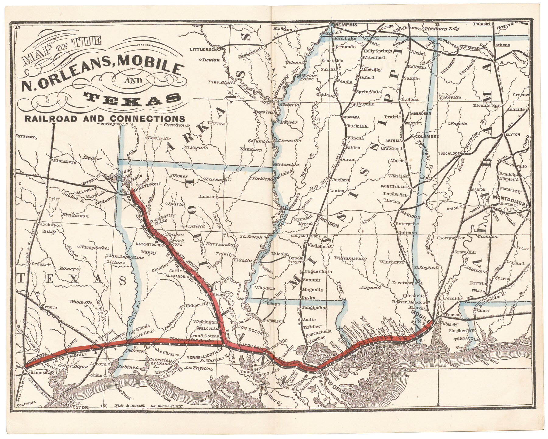
Map of the N. Orleans, Mobile and Texas Railroad and Connections
-
Map/Doc
96611
-
Collection
Cobb Digital Map Collection
-
Object Dates
1871 (Creation Date)
-
Subjects
Railroads
-
Height x Width
8.9 x 11.1 inches
22.6 x 28.2 cm
-
Medium
digital image
-
Comments
Courtesy of John & Diana Cobb.
To view the booklet, "The New Orleans, Mobile and Texas Railroad Company", in which this map was contained, click the "Download PDF" link above.
Part of: Cobb Digital Map Collection
Map of the Iron Mountain Route - St. Louis, Iron Mountain and Southern Railway and connections, the great fast mail line to St. Louis, Arkansas and Texas

Print $20.00
- Digital $50.00
Map of the Iron Mountain Route - St. Louis, Iron Mountain and Southern Railway and connections, the great fast mail line to St. Louis, Arkansas and Texas
1882
Size 14.9 x 24.1 inches
Map/Doc 95787
Rand, McNally & Co.'s Texas

Print $20.00
- Digital $50.00
Rand, McNally & Co.'s Texas
1902
Size 21.3 x 28.4 inches
Map/Doc 95886
Revised map of the State of Texas

Print $20.00
- Digital $50.00
Revised map of the State of Texas
1876
Size 19.6 x 19.7 inches
Map/Doc 95755


The Industrial Evolution of the agricultural wonderland of the southwest

Print $20.00
- Digital $50.00
The Industrial Evolution of the agricultural wonderland of the southwest
1927
Size 13.7 x 16.7 inches
Map/Doc 96760
The MKT - Texas Empire of the South

Print $20.00
- Digital $50.00
The MKT - Texas Empire of the South
1905
Size 18.6 x 40.6 inches
Map/Doc 97034

Rand, McNally & Co.'s Texas

Print $20.00
- Digital $50.00
Rand, McNally & Co.'s Texas
1900
Size 21.6 x 28.5 inches
Map/Doc 95843
What to See - Where to Go in El Paso, Texas

What to See - Where to Go in El Paso, Texas
1929
Size 9.4 x 8.4 inches
Map/Doc 97048
Plat showing Gulf Coast Irrigation Company's lands at Raymondville, Lyford and Sebastian, Texas.

Print $20.00
- Digital $50.00
Plat showing Gulf Coast Irrigation Company's lands at Raymondville, Lyford and Sebastian, Texas.
1910
Size 13.9 x 16.9 inches
Map/Doc 95797
Oklahoma and Indian Territory Along the Frisco

Oklahoma and Indian Territory Along the Frisco
1905
Map/Doc 96771
You may also like
Sketch showing the Connnecting Lines run by Olliver Hedgcoxe for the Texan Emigration and Land Company connecting their Surveys made by them in Peters' Colony, Texas

Print $40.00
- Digital $50.00
Sketch showing the Connnecting Lines run by Olliver Hedgcoxe for the Texan Emigration and Land Company connecting their Surveys made by them in Peters' Colony, Texas
1854
Size 45.8 x 61.9 inches
Map/Doc 1969
Lake Buchanan, Burnet and Llano Counties, Texas

Print $20.00
- Digital $50.00
Lake Buchanan, Burnet and Llano Counties, Texas
1935
Size 20.7 x 14.4 inches
Map/Doc 3136
Uvalde County Rolled Sketch 8

Print $20.00
- Digital $50.00
Uvalde County Rolled Sketch 8
Size 21.3 x 37.5 inches
Map/Doc 8093
State Prison System, Cherokee County

Print $20.00
- Digital $50.00
State Prison System, Cherokee County
Size 17.9 x 13.8 inches
Map/Doc 73561
Hemphill County Sketch file 6b

Print $20.00
- Digital $50.00
Hemphill County Sketch file 6b
1903
Size 13.7 x 24.3 inches
Map/Doc 11752
Crockett County Rolled Sketch 65

Print $20.00
- Digital $50.00
Crockett County Rolled Sketch 65
1948
Size 13.4 x 27.5 inches
Map/Doc 5608
Freestone County Sketch File 6

Print $4.00
- Digital $50.00
Freestone County Sketch File 6
1858
Size 10.3 x 8.8 inches
Map/Doc 23050
Upton County Working Sketch 8

Print $20.00
- Digital $50.00
Upton County Working Sketch 8
1916
Size 21.9 x 16.8 inches
Map/Doc 69504
[E. L. & R. R. Block E, Showing Mound Lake]
![91335, [E. L. & R. R. Block E, Showing Mound Lake], Twichell Survey Records](https://historictexasmaps.com/wmedia_w700/maps/91335-1.tif.jpg)
Print $2.00
- Digital $50.00
[E. L. & R. R. Block E, Showing Mound Lake]
Size 14.8 x 6.3 inches
Map/Doc 91335
Gaines County Sketch File 15

Print $5.00
- Digital $50.00
Gaines County Sketch File 15
1956
Size 11.6 x 8.8 inches
Map/Doc 23202
Map of the City of Austin Texas

Map of the City of Austin Texas
1933
Size 22.5 x 17.6 inches
Map/Doc 76050
Bastrop County Sketch File 9A

Print $40.00
- Digital $50.00
Bastrop County Sketch File 9A
Map/Doc 88484