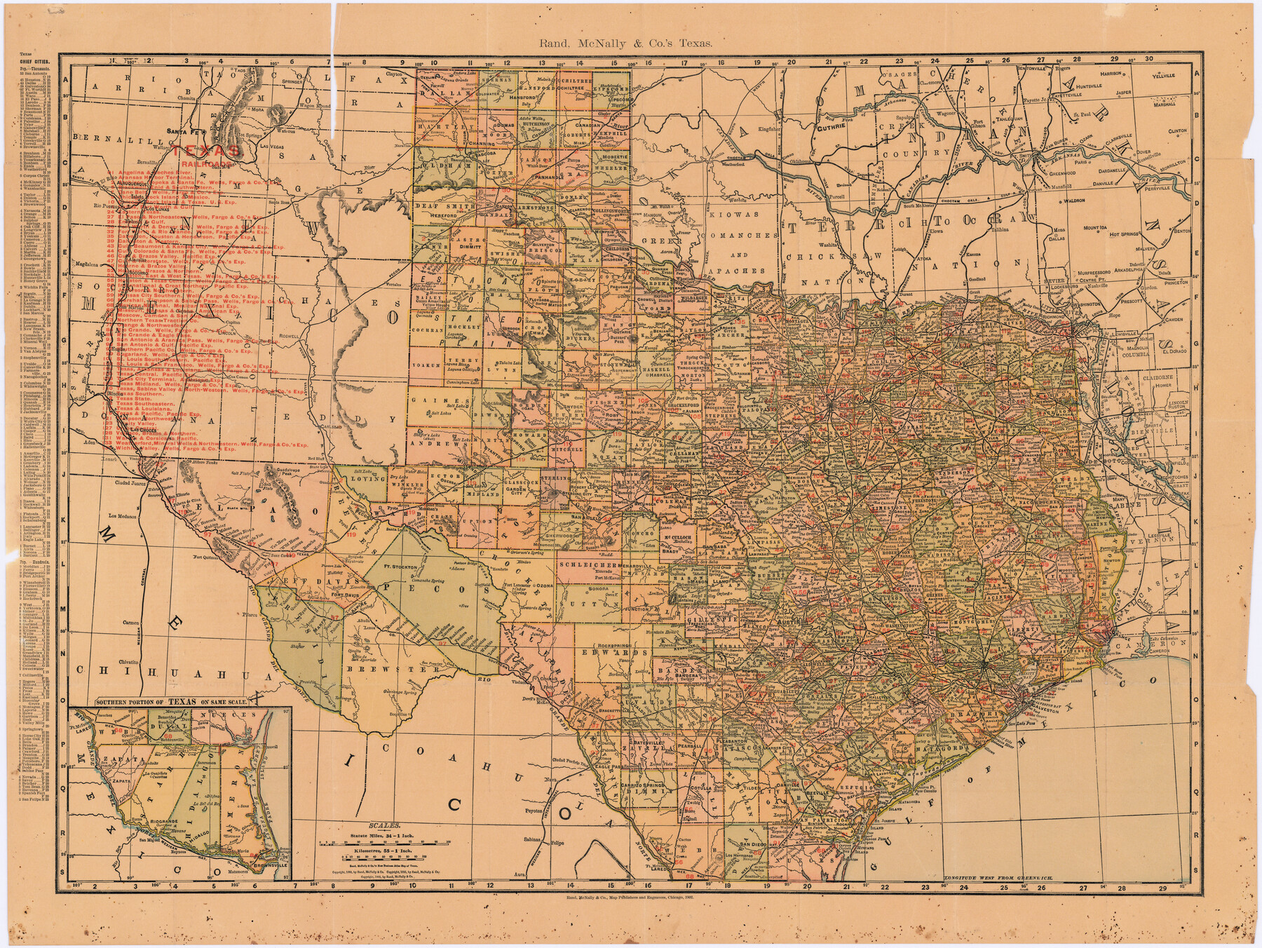
Rand, McNally & Co.'s Texas
[Inset:] Southern Portion of Texas
-
Map/Doc
95886
-
Collection
Cobb Digital Map Collection
-
Object Dates
1902 (Creation Date)
-
People and Organizations
Rand McNally & Co. (Publisher)
Rand McNally & Co. (Printer)
-
Subjects
Railroads State of Texas
-
Height x Width
21.3 x 28.4 inches
54.1 x 72.1 cm
-
Medium
digital image
-
Scale
1" = 34 statute miles
-
Comments
Courtesy of John & Diana Cobb.
To view timetables and information on verso, click "Download PDF" link above.
Part of: Cobb Digital Map Collection
What to See - Where to Go in El Paso, Texas

What to See - Where to Go in El Paso, Texas
1929
Size 9.4 x 8.4 inches
Map/Doc 97048
Map of Texas with population and location of principal towns and cities according to latest reliable statistics

Print $20.00
- Digital $50.00
Map of Texas with population and location of principal towns and cities according to latest reliable statistics
1906
Size 18.6 x 20.5 inches
Map/Doc 95871

The Newest Land Of Promise - The Pecos Valley in Texas

Print $20.00
- Digital $50.00
The Newest Land Of Promise - The Pecos Valley in Texas
1900
Size 17.8 x 22.8 inches
Map/Doc 97037
The Principal Transportation Lines west of Chicago, St. Louis, & New Orleans, to accompany the report on the Internal Commerce of the United States for 1880

Print $20.00
- Digital $50.00
The Principal Transportation Lines west of Chicago, St. Louis, & New Orleans, to accompany the report on the Internal Commerce of the United States for 1880
1880
Size 26.7 x 22.7 inches
Map/Doc 95906
The MKT - Texas Empire of the South

Print $20.00
- Digital $50.00
The MKT - Texas Empire of the South
1905
Size 18.6 x 40.6 inches
Map/Doc 97034

Rand, McNally & Co.'s Texas

Print $20.00
- Digital $50.00
Rand, McNally & Co.'s Texas
1902
Size 21.3 x 28.4 inches
Map/Doc 95886
Map of the Cincinnati, New Orleans and Texas Pacific Ry and connections

Print $20.00
- Digital $50.00
Map of the Cincinnati, New Orleans and Texas Pacific Ry and connections
1889
Size 7.7 x 12.2 inches
Map/Doc 95758
Under Sapphire Skies San Antonio

Under Sapphire Skies San Antonio
1928
Size 9.4 x 6.4 inches
Map/Doc 97043
Corpus Christi, Where Texas Meets the Sea

Corpus Christi, Where Texas Meets the Sea
1928
Size 9.7 x 6.9 inches
Map/Doc 97065
[Map of Florida]
![96622, [Map of Florida], Cobb Digital Map Collection](https://historictexasmaps.com/wmedia_w700/maps/96622.tif.jpg)
Print $20.00
- Digital $50.00
[Map of Florida]
1869
Size 9.0 x 9.6 inches
Map/Doc 96622
You may also like
Map of Potter County

Print $20.00
- Digital $50.00
Map of Potter County
1895
Size 23.6 x 18.4 inches
Map/Doc 4617
Brooks County Rolled Sketch 26

Print $20.00
- Digital $50.00
Brooks County Rolled Sketch 26
1945
Size 33.7 x 43.3 inches
Map/Doc 8539
Refugio County Sketch File 21

Print $20.00
- Digital $50.00
Refugio County Sketch File 21
1933
Size 17.8 x 22.1 inches
Map/Doc 12248
Presidio County Working Sketch 67

Print $20.00
- Digital $50.00
Presidio County Working Sketch 67
1960
Size 36.2 x 36.5 inches
Map/Doc 71744

[Surveys in the Bexar District along the Cibolo Creek]
![3168, [Surveys in the Bexar District along the Cibolo Creek], General Map Collection](https://historictexasmaps.com/wmedia_w700/maps/3168.tif.jpg)
Print $2.00
- Digital $50.00
[Surveys in the Bexar District along the Cibolo Creek]
1846
Size 5.1 x 6.7 inches
Map/Doc 3168
Dallam County

Print $20.00
- Digital $50.00
Dallam County
1901
Size 42.3 x 52.4 inches
Map/Doc 16953
The Dawn of Humans Peopling of the Americas

The Dawn of Humans Peopling of the Americas
2000
Size 31.3 x 20.5 inches
Map/Doc 96841
U.S. Coast and Geodetic First Order Triangulation Stations Geographic Positions Plotted by W.D. Twichell

Digital $50.00
U.S. Coast and Geodetic First Order Triangulation Stations Geographic Positions Plotted by W.D. Twichell
Size 18.0 x 22.7 inches
Map/Doc 92044
Portion of States Submerged Area in Matagorda Bay

Print $20.00
- Digital $50.00
Portion of States Submerged Area in Matagorda Bay
1922
Size 14.0 x 12.5 inches
Map/Doc 2955
Real County Working Sketch 34

Print $20.00
- Digital $50.00
Real County Working Sketch 34
1948
Size 25.6 x 29.0 inches
Map/Doc 71926
Kenedy County Rolled Sketch 9

Print $20.00
- Digital $50.00
Kenedy County Rolled Sketch 9
Size 27.1 x 41.7 inches
Map/Doc 6469